


Summary
Holmes Rock is rising to 45 m (49 yd) north of Greenwich Island and west of Aitcho group in the South Shetland Islands, Antarctica. The area was visited by early 19th century sealers.
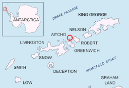 Location of Aitcho Islands in the South Shetland Islands. | |
 Holmes Rock Location of Holmes Rock  Holmes Rock Holmes Rock (Antarctica) | |
| Geography | |
|---|---|
| Location | Antarctica |
| Coordinates | 62°22′58.8″S 59°50′06″W / 62.383000°S 59.83500°W |
| Archipelago | South Shetland Islands |
| Administration | |
| Administered under the Antarctic Treaty System | |
| Demographics | |
| Population | Uninhabited |
The feature is named after Captain Jeremiah Holmes, Master of the American sealing vessel Emeline that visited the South Shetlands in 1820-21 and operated from nearby Clothier Harbour.
Location edit
The rock is located 2.3 km (1.43 mi) west of Riksa Islands, 2.1 km (1.30 mi) west-northwest of Emeline Island, 1.53 km (0.95 mi) north-northeast of Stoker Island, 4.4 km (2.73 mi) east-southeast of Romeo Island, 4.15 km (2.58 mi) south by west of Table Island and 2.55 km (1.58 mi) southwest of Morris Rock. It is separated from neighbouring Nikudin Rock to the west-southwest by a 150 m wide passage (British mapping in 1968, Chilean in 1971, Argentine in 1980, and Bulgarian in 2005 and 2009).
See also edit
Maps edit
- L.L. Ivanov et al. Antarctica: Livingston Island and Greenwich Island, South Shetland Islands. Scale 1:100000 topographic map. Sofia: Antarctic Place-names Commission of Bulgaria, 2005.
- L.L. Ivanov. Antarctica: Livingston Island and Greenwich, Robert, Snow and Smith Islands. Scale 1:120000 topographic map. Troyan: Manfred Wörner Foundation, 2009. ISBN 978-954-92032-6-4
References edit
External links edit
- SCAR Composite Antarctic Gazetteer.
