


Summary
Holuhraun ([ˈhɔːlʏˌr̥œyːn] ⓘ) is a lava field just north of the Vatnajökull ice cap, in the Icelandic Highlands, in Suður-Þingeyjarsýsla, Northeastern Region, Iceland. The lava field was created by fissure eruptions.[1] After a research expedition in 1880, the lava field was initially called Kvislarhraun [ˈkʰvɪstlar̥ˌr̥œyːn]. Four years later, it received its current name from geologist and geographer Þorvaldur Thoroddsen.[1] Holuhraun was the site of a volcanic eruption which began on 29 August 2014 and produced a lava field of more than 85 km2 (33 sq mi)[2] and 1.4 km3 (0.34 cu mi) – the largest in Iceland since 1783.[3]
Holuhraun | |
|---|---|
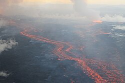 The Holuhraun lava field, on 4 September 2014, during the 2014 eruption | |
 Holuhraun Map of Iceland showing the location of Holuhraun. | |
| Coordinates: 64°51′N 16°50′W / 64.85°N 16.83°W | |
| Location | Suður-Þingeyjarsýsla, Northeastern Region, Iceland |
| Topo map |  Geological features near Holuhraun with the source of the lava being the Bárðarbunga central volcano outlined in red. The 2014 Holuhraun lava flow is a deep shade of purple, the 1797 Holuhraun lava flow is shaded slightly lighter, while other older Bárðarbunga associated lava flows are light purple. Shading also shows: calderas, other central volcanoes, fissure swarms, subglacial terrain above 1,100 m (3,600 ft) and seismically active areas between 1995 to 2007. Clicking on the image enables full window and mouse-over with more detail. |
Geography edit
Holuhraun is situated at the southern end of Ódáðahraun [ˈouːˌtauːðaˌr̥œyːn], which is one of the largest lava fields in the country. The main volume of the Jökulsá á Fjöllum river flows from the eastern side of Holuhraun, in the Kverkfjöll area.[1] Hrímalda [ˈr̥iːmˌalta], Urðarháls [ˈʏrðarˌhauls] and Kistufell [ˈcʰɪstʏˌfɛtl̥] are to the west of Holuhraun, with Dyngjuháls [ˈtiɲcʏˌhauls] and Trölladyngja beyond.[4] The Dyngjujökull glacier, which is part of Vatnajökull, is to the immediate south.[1][4] Holuhraun is about 15 km (9.3 mi) south of the Askja caldera,[5] and the Bárðarbunga volcano is 41.39 km (25.7 mi) to the south-west[6] of Holuhraun. Holuhraun is traversed by an unnumbered road, which connects to the Route F910 gravel road at both the east and the west ends.[7][8]
Volcanism edit
Located at the northern and southern extensions of the Bárðarbunga and Askja fissure systems, respectively, the soil is mainly composed of lavas derived from these volcanoes, either in the form of flows or alluvial deposits of volcanic origin. The geological configuration, along with the presence of nearby subglacial volcanoes such as Bárðarbunga and Grímsvötn, is responsible for the risk of jökulhlaups, which have affected Holuhraun repeatedly.


Until 2014, the surface of the lava field was of an older lava flow, which was assumed to have erupted from a vent associated with Askja in 1797, but this is no longer accepted.[a] In the early hours of 29 August 2014, a small fissure eruption occurred in Holuhraun at the northern end of a magma intrusion which had moved progressively north, since 16 August, from the Bárðarbunga volcano.[3] The progression of the magma intrusion was accompanied by an earthquake swarm.[13] The eruption began just after midnight and stopped at 04:00 GMT.[14] The active fissure was about 600 m (660 yd) in length.[15]
Another fissure eruption started in Holuhraun at around 05:05 GMT on the morning of 31 August 2014, in the same rift as the eruption which had occurred two days earlier.[16] The eruptive fissure was estimated to be 1.5 km (0.93 mi) long.[15] By 4 September, the total area of the lava flow was estimated at 10.8 km2 (4.2 sq mi).[15] Two new eruptive fissures formed south of the main eruption site, on 5 September.[15] The new fissures were substantially smaller than the older fissure.[15] By 7 September, the lava flow had extended 11 km (6.8 mi) to the north, and had reached the main western branch of the Jökulsá á Fjöllum river.[15] The eruption showed no visible activity in the southern fissure, on the evening of 7 September.[15] The lava flow is considered to be the largest in recent decades in Iceland and covered 44 km2 (17 sq mi) on 29 September.[17] The volcanic eruption in Holuhraun continued with similar intensity as the previous few weeks. The lava field covered 63 km2 (24 sq mi) in late October. On 11 November, it was reported that the lava field extended to 70 km2 (27 sq mi) and more than 1 km3 (0.24 cu mi) in volume - the largest in Iceland since the Laki eruption of 1783.[3][18]
The eruption ended on 27 February 2015. The Holuhraun lava field measures more than 85 km2 (33 sq mi) and the volume is around 1.6 km3 (0.38 cu mi).
Several names were proposed for the new lava field in the Holuhraun area, among them Flæðahraun, Nornahraun, and Urðarbruni. Finally, the decision was to keep the existing name Holuhraun,[19] which is also consistent with current geological thought.[a]
See also edit
Notes edit
- ^ a b There is now known to be overlap in compositional studies and work is ongoing to understand this overlap region where vents may be some distance from the magna reservoir, fissure swarms may overlap and the Bárðarbunga volcanic system appears to have been much more productive than once assummed. The 1797 composition is very similar to that of 2014,[9] and the 1797 flow was reassigned to the Bárðarbunga system on this basis.[10] All sources on this issue prior to 2015 assigning the 1797 flow to Askja on the assumption of geographical proximity appear to be inconsistent with the compositional analysis data in the peer reviewed literature available to date,[11][12] and the distance of lateral dyke intrusions possible from Bárðarbunga.
References edit
- ^ a b c d "Holuhraun". Nordic Adventure Travel. Retrieved 29 August 2014.
- ^ Geiger, Harri; Mattsson, Tobias; Deegan, Frances M.; Troll, Valentin R.; Burchardt, Steffi; Gudmundsson, Ólafur; Tryggvason, Ari; Krumbholz, Michael; Harris, Chris (2016). "Magma plumbing for the 2014–2015 Holuhraun eruption, Iceland". Geochemistry, Geophysics, Geosystems. 17 (8): 2953–2968. Bibcode:2016GGG....17.2953G. doi:10.1002/2016GC006317. ISSN 1525-2027. S2CID 132951014.
- ^ a b c "Over 1 km3 of lava erupted at Holuhraun". Archived from the original on 13 November 2014. Retrieved 13 November 2014.
- ^ a b "Holuhraun Map - Iceland". mapcarta.com. Retrieved 4 September 2014.
- ^ "Fissure eruption in Holuhraun lava field". Ríkisútvarpið. 29 August 2014. Retrieved 29 August 2014.
- ^ "Coordinate Distance Calculator". boulter.com. Retrieved 3 September 2014.
- ^ "Map of Iceland". ras.is. Archived from the original on 4 September 2014. Retrieved 3 September 2014.
- ^ "Sprengisandur route". brians4x4adventures.com. Archived from the original on 28 December 2013. Retrieved 3 September 2014.
- ^ Hartley, M.E.; Bali, E.; Maclennan, J.; Neave, D.A.; Halldórsson, S.A. (2018). "Melt inclusion constraints on petrogenesis of the 2014–2015 Holuhraun eruption, Iceland". Contributions to Mineralogy and Petrology. 173: 1–23. Bibcode:2018CoMP..173...10H. doi:10.1007/s00410-017-1435-0.: 7
- ^ Sigmarsson, O.; Halldórsson, S.A. (2015). "Delimiting Bárðarbunga and Askja volcanic systems with Sr-and Nd-isotope ratios" (PDF). Jökull. 65: 17–27. Retrieved 14 April 2024.
- ^ "Askja". Smithsonian Institution. 16 September 2014. Retrieved 9 October 2014.
- ^ "New volcanic eruption in Iceland blasts lava high into the air". CBS News. 1 September 2014. Retrieved 2 September 2014.
- ^ "Bárðarbunga awakes". sciencemag.org. 24 August 2014. Retrieved 4 September 2014.
- ^ "Eruption in Bardarbunga Volcano System, but No Threat to Air Traffic". Austrian Tribune. 30 August 2014. Retrieved 2 September 2014.
- ^ a b c d e f g "Bárðarbunga - updated information". Icelandic Met Office. 31 August 2014. Retrieved 31 August 2014.
- ^ "Another eruption in Holuhraun". mbl.is. 31 August 2014. Retrieved 31 August 2014.
- ^ "Winter arrives at Holuhraun". RÚV. 29 September 2014. Retrieved 9 October 2014.
- ^ "Latest information on volcanic activity". RÚV. 24 October 2014. Retrieved 19 November 2014.
- ^ Paul Fontaine (16 December 2015). "Holuhraun to be named Holuhraun". The Reykjavík Grapevine. Retrieved 2 July 2016.
External links edit
- Icelandic Meteorological Office page with latest updates on the Holuhraun eruption
- 3d map of volcanic activity in Holuhraun updated live from IMO