


Summary
Gakog (Hongyuan) County (Tibetan: སྐ་ཆུ་རྫོང་། or སྐ་ཁོག་རྫོང་།; Chinese: 红原县) is a county in the north of Sichuan Province, China. It is under the administration of the Ngawa Tibetan and Qiang Autonomous Prefecture. There is a river called Ka Chu/Gaqu (སྐ་ཆུ།) in the area and kog means "valley" or "area"; thus it means the area of the Ga River.[2]
Hongyuan County
红原县 • སྐ་ཁོག་རྫོང་། Gakog, Gaqu, Hungyoin | |
|---|---|
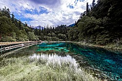 Five Flowers Lake | |
 Location of Hongyuan County (red) in Ngawa Prefecture (yellow) and Sichuan | |
 Hongyuan Location in Sichuan  Hongyuan Hongyuan (China) | |
| Coordinates: 32°52′35″N 102°32′24″E / 32.87639°N 102.54000°E | |
| Country | China |
| Province | Sichuan |
| Autonomous prefecture | Ngawa |
| County seat | Kyungqu |
| Area | |
| • Total | 8,398 km2 (3,242 sq mi) |
| Population (2020)[1] | |
| • Total | 46,644 |
| • Density | 5.6/km2 (14/sq mi) |
| Time zone | UTC+8 (China Standard) |
| Website | www |
| Hongyuan County | |||||||||||
|---|---|---|---|---|---|---|---|---|---|---|---|
| Chinese name | |||||||||||
| Simplified Chinese | 红原县 | ||||||||||
| Traditional Chinese | 紅原縣 | ||||||||||
| |||||||||||
| Tibetan name | |||||||||||
| Tibetan | རྐ་ཁོག་རྫོང་། སྐ་ཆུ་རྫོང་། ཧུང་ཡོན་རྫོང་། | ||||||||||
| |||||||||||

This is the only county under the Prefecture with entirely yak herding pastoralists. The average altitude above the sea level is 3,600 m (11,800 ft). About 8,398 square meter and about 40,000 people reside (2004) mostly Amdo Tibetan. The language is spoken is one of the most conservative dialect among the Amdo Tibetan varieties. The county seat is Kyungqu (a.k.a. Khyungchu).
Southwest University for Nationalities maintains the Qinghai-Tibetan Plateau Ecological Environmental Protection and Advanced Technology for Animal Husbandry in Hongyuan County.[3]
The country is served by Aba Hongyuan Airport.
Climate edit
| Climate data for Hongyuan, elevation 3,492 m (11,457 ft), (1991−2020 normals, extremes 1981−2010) | |||||||||||||
|---|---|---|---|---|---|---|---|---|---|---|---|---|---|
| Month | Jan | Feb | Mar | Apr | May | Jun | Jul | Aug | Sep | Oct | Nov | Dec | Year |
| Record high °C (°F) | 15.4 (59.7) |
16.6 (61.9) |
19.6 (67.3) |
23.0 (73.4) |
24.6 (76.3) |
26.0 (78.8) |
25.7 (78.3) |
25.6 (78.1) |
24.9 (76.8) |
23.1 (73.6) |
15.4 (59.7) |
14.4 (57.9) |
26.0 (78.8) |
| Mean daily maximum °C (°F) | 2.7 (36.9) |
4.7 (40.5) |
7.2 (45.0) |
10.9 (51.6) |
13.8 (56.8) |
16.0 (60.8) |
18.4 (65.1) |
18.2 (64.8) |
15.5 (59.9) |
10.9 (51.6) |
7.0 (44.6) |
3.7 (38.7) |
10.8 (51.4) |
| Daily mean °C (°F) | −8.8 (16.2) |
−5.6 (21.9) |
−1.3 (29.7) |
2.8 (37.0) |
6.4 (43.5) |
9.7 (49.5) |
11.5 (52.7) |
10.8 (51.4) |
7.9 (46.2) |
3.0 (37.4) |
−2.7 (27.1) |
−7.6 (18.3) |
2.2 (35.9) |
| Mean daily minimum °C (°F) | −18.5 (−1.3) |
−14.3 (6.3) |
−7.7 (18.1) |
−3.5 (25.7) |
0.4 (32.7) |
4.6 (40.3) |
5.8 (42.4) |
4.8 (40.6) |
2.5 (36.5) |
−2.1 (28.2) |
−9.5 (14.9) |
−16.2 (2.8) |
−4.5 (23.9) |
| Record low °C (°F) | −36.0 (−32.8) |
−30.2 (−22.4) |
−26.3 (−15.3) |
−14.9 (5.2) |
−14.8 (5.4) |
−4.4 (24.1) |
−2.6 (27.3) |
−4.9 (23.2) |
−6.7 (19.9) |
−15.3 (4.5) |
−26.6 (−15.9) |
−30.7 (−23.3) |
−36.0 (−32.8) |
| Average precipitation mm (inches) | 7.3 (0.29) |
11.0 (0.43) |
26.5 (1.04) |
50.3 (1.98) |
107.6 (4.24) |
131.0 (5.16) |
122.1 (4.81) |
109.3 (4.30) |
111.6 (4.39) |
70.8 (2.79) |
11.7 (0.46) |
3.9 (0.15) |
763.1 (30.04) |
| Average precipitation days (≥ 0.1 mm) | 5.9 | 8.0 | 12.6 | 15.9 | 21.2 | 21.3 | 18.8 | 17.2 | 19.5 | 17.9 | 6.8 | 4.1 | 169.2 |
| Average snowy days | 8.1 | 10.6 | 16.8 | 16.0 | 8.6 | 1.6 | 0.2 | 0.4 | 2.3 | 13.9 | 9.0 | 5.7 | 93.2 |
| Average relative humidity (%) | 58 | 59 | 65 | 68 | 72 | 75 | 76 | 77 | 79 | 77 | 66 | 59 | 69 |
| Mean monthly sunshine hours | 215.4 | 186.6 | 199.0 | 203.1 | 196.1 | 165.5 | 201.5 | 206.6 | 168.9 | 171.4 | 210.9 | 225.7 | 2,350.7 |
| Percent possible sunshine | 68 | 60 | 53 | 52 | 46 | 39 | 47 | 51 | 46 | 49 | 68 | 73 | 54 |
| Source: China Meteorological Administration[4][5] | |||||||||||||
Administrative divisions edit
Hongyuan County has 6 townships and 4 townships:
| Name | Simplified Chinese | Hanyu Pinyin | Tibetan | Wylie | Administrative division code | |
|---|---|---|---|---|---|---|
| Towns | ||||||
| Kyungqu Town (Khyungchu, Qiongxi) |
邛溪镇 | Qióngxī Zhèn | ཁྱུང་མཆུ་གྲོང་རྡལ། | khyung mchu grong rdal | 513233100 | |
| Da'gyailing Town (Sajinse, Shuajingsi) |
刷经寺镇 | Shuājīngsì Zhèn | ལྟ་རྒྱལ་གླིང་གྲོང་རྡལ། | lta rgyal gling grong rdal | 513233101 | |
| Waqên Town (Waqie) |
瓦切镇 | Wǎqiē Zhèn | སྦྲ་ཆེན་གྲོང་རྡལ། | sbra chen grong rdal | 513233102 | |
| Amqog Town (Anqog, Anqu) |
安曲镇 | Ānqǔ Zhèn | ཨ་མཆོག་གྲོང་རྡལ། | a mchog grong rdal | 513233103 | |
| Sêrdêu Town (Sêrdiu, Sedi) |
色地镇 | Sèdì Zhèn | གསེར་རྡེའུ་གྲོང་རྡལ། | gser rde'u grong rdal | 513233104 | |
| Lungsi Town (Longriba, Longri) |
龙日镇 | Lòngrì Zhèn | ལུང་ཟི་གྲོང་རྡལ། | lung zi grong rdal | 513233105 | |
| Townships | ||||||
| Gyarong Township (Jiangrong) |
江茸乡 | Jiāngróng Xiāng | སྐྱ་རོང་ཡུལ་ཚོ། | skya rong yul tsho | 513233202 | |
| Carima Township (Cha'erma) |
查尔玛乡 | Chá'ěrmǎ Xiāng | ཚ་རི་མ་ཡུལ་ཚོ། | tsha ri ma yul tsho | 513233203 | |
| Amoi Township (Amu) |
阿木乡 | Āmù Xiāng | ཨ་མོའི་ཡུལ་ཚོ། | a mo'i yul tsho | 513233205 | |
| Mêwa Township (Maiwa) |
麦洼乡 | Màiwā Xiāng | རྨེ་བ་ཡུལ་ཚོ། | rme ba yul tsho | 513233207 | |
References edit
- ^ "阿坝州第七次全国人口普查公报第二号——县(市)人口情况" (in Chinese). Government of Ngawa Prefecture. 2021-06-11.
- ^ "Kakhok | Shanti Knowledge Maps". mandala.shanti.virginia.edu. Retrieved 2017-11-18.
- ^ "About Us Archived 2016-03-04 at the Wayback Machine." Southwest University for Nationalities. Retrieved on November 16, 2015.
- ^ 1991-2020 normals "Climate averages from 1991 to 2020". China Meteorological Administration. 2023-04-20. Archived from the original on 2023-04-17.
- ^ 1981-2010 extremes 中国气象数据网 – WeatherBk Data (in Simplified Chinese). China Meteorological Administration. Retrieved 14 April 2023.