


Summary
Hoogersmilde is a village in the Dutch province of Drenthe. It is a part of the municipality of Midden-Drenthe, and lies about 16 km southwest of Assen.
Hoogersmilde | |
|---|---|
Village | |
 Hoogersmilde, artwork at the entrance to the sand-lime brick factory | |
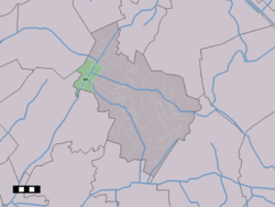 The town centre (dark green) and the statistical district (light green) of Hoogersmilde in the municipality of Midden-Drenthe. | |
 Hoogersmilde Location in the Netherlands  Hoogersmilde Hoogersmilde (Netherlands) | |
| Coordinates: 52°54′N 6°24′E / 52.900°N 6.400°E | |
| Country | Netherlands |
| Province | Drenthe |
| Municipality | Midden-Drenthe |
| Area | |
| • Total | 20.29 km2 (7.83 sq mi) |
| Elevation | 13 m (43 ft) |
| Population (2021)[1] | |
| • Total | 1,665 |
| • Density | 82/km2 (210/sq mi) |
| Time zone | UTC+1 (CET) |
| • Summer (DST) | UTC+2 (CEST) |
| Postal code | 9422 & 9423[1] |
| Dialing code | 0591 |
History edit
The village was first mentioned in 1634 as Hooge Smilde, and means "high Smilde".[3] In 1614, a large region of raised bog was bought by a group of Amsterdam merchant lead to Adriaan Pauw to excavate the peat.[4] In 1634, Adriaan Pauw was made Heer of the Heerlijkheid Smilde in 1633. Hoogersmilde is the oldest settlement and was often referred to as Oude-Smilde.[3] The excavation stagnated around 1730, however it restarted after the Drentsche Hoofdvaart was dug between 1767 and 1780.[4]
The Heerlijkheid was dissolved in 1795, and the municipality of Smilde was created with neighbouring Smilde as a capital.[5] The Dutch Reformed church was built in 1845.[4] Hoogersmilde was home to 660 people in 1840.[5]
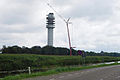
The Zendstation Smilde is located in Hoogersmilde, it partially collapsed after a fire on 15 July 2011.[6] The Blauwe Meer, an excavation lake, is situated south of Hoogersmilde.[7]
Education edit
There are two primary schools, De Vaart and Pieter van Thuyl.[8]
Gallery edit
-
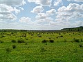 Landscape around Hoogersmilde
 -
 The collapsed tower (2011)
 -
 Repaired tower (2012)


References edit
- ^ a b c "Kerncijfers wijken en buurten 2021". Central Bureau of Statistics. Retrieved 11 April 2022.
- ^ "Postcodetool for 9423NA". Actueel Hoogtebestand Nederland (in Dutch). Het Waterschapshuis. Retrieved 11 April 2022.
- ^ a b "Hoogersmilde - (geografische naam)". Etymologiebank (in Dutch). Retrieved 11 April 2022.
- ^ a b c Ronald Stenvert (2001). Hoogersmilde (in Dutch). Zwolle: Waanders. p. 61. ISBN 90 400 9454 3. Retrieved 11 April 2022.
- ^ a b "Hoogersmilde". Plaatsengids (in Dutch). Retrieved 11 April 2022.
- ^ Mast TV-transmitter Smilde collapsed Archived July 15, 2011, at the Wayback Machine, 15 July 2011
- ^ "Recreatieplas Het Blauwe Meer". www.drenthe.nl (in Dutch). Retrieved 2022-08-03.
- ^ "Scholen" (in Dutch). Midden-Drenthe. Retrieved 2023-04-15.