
KNOWPIA
WELCOME TO KNOWPIA

Houppeville 
Summary
Houppeville (French pronunciation: [upvil]) is a commune in the Seine-Maritime department in the Normandy region in northern France.
Houppeville | |
|---|---|
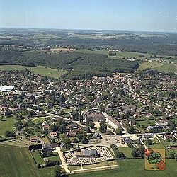 An aerial view of Houppeville | |
 Coat of arms | |
Location of Houppeville .mw-parser-output .locmap .od{position:absolute}.mw-parser-output .locmap .id{position:absolute;line-height:0}.mw-parser-output .locmap .l0{font-size:0;position:absolute}.mw-parser-output .locmap .pv{line-height:110%;position:absolute;text-align:center}.mw-parser-output .locmap .pl{line-height:110%;position:absolute;top:-0.75em;text-align:right}.mw-parser-output .locmap .pr{line-height:110%;position:absolute;top:-0.75em;text-align:left}.mw-parser-output .locmap .pv>div{display:inline;padding:1px}.mw-parser-output .locmap .pl>div{display:inline;padding:1px;float:right}.mw-parser-output .locmap .pr>div{display:inline;padding:1px;float:left}html.skin-theme-clientpref-night .mw-parser-output .od,html.skin-theme-clientpref-night .mw-parser-output .od .pv>div,html.skin-theme-clientpref-night .mw-parser-output .od .pl>div,html.skin-theme-clientpref-night .mw-parser-output .od .pr>div{background:#000;color:#fff}html.skin-theme-clientpref-night .mw-parser-output .locmap{filter:grayscale(0.6)}@media(prefers-color-scheme:dark){html.skin-theme-clientpref-os .mw-parser-output .locmap{filter:grayscale(0.6)}html.skin-theme-clientpref-os .mw-parser-output .od,html.skin-theme-clientpref-os .mw-parser-output .od .pv>div,html.skin-theme-clientpref-os .mw-parser-output .od .pl>div,html.skin-theme-clientpref-os .mw-parser-output .od .pr>div{background:#000;color:#fff}}  Houppeville  Houppeville | |
| Coordinates: 49°30′48″N 1°04′49″E / 49.5133°N 1.0803°E | |
| Country | France |
| Region | Normandy |
| Department | Seine-Maritime |
| Arrondissement | Rouen |
| Canton | Notre-Dame-de-Bondeville |
| Intercommunality | Métropole Rouen Normandie |
| Government | |
| • Mayor (2020–2026) | Monique Bourget[1] |
| Area 1 | 20.8 km2 (8.0 sq mi) |
| Population (2021)[2] | 2,884 |
| • Density | 140/km2 (360/sq mi) |
| Time zone | UTC+01:00 (CET) |
| • Summer (DST) | UTC+02:00 (CEST) |
| INSEE/Postal code | 76367 /76770 |
| Elevation | 39–169 m (128–554 ft) (avg. 154 m or 505 ft) |
| 1 French Land Register data, which excludes lakes, ponds, glaciers > 1 km2 (0.386 sq mi or 247 acres) and river estuaries. | |
Geography edit
A large village of forestry and farming, surrounded by woodland and situated just 4 miles (6.4 km) north of the centre of Rouen, at the junction of the D90, D121 and the D321 roads.
Heraldry edit
 |
The arms of Houppeville are blazoned : Or, on a bend gules a leopard and a fleur-de-lys of the field, overall a tree eradicated vert.
|
Population edit
| Year | Pop. | ±% p.a. |
|---|---|---|
| 1968 | 1,112 | — |
| 1975 | 1,346 | +2.77% |
| 1982 | 1,901 | +5.06% |
| 1990 | 2,378 | +2.84% |
| 1999 | 2,405 | +0.13% |
| 2007 | 2,396 | −0.05% |
| 2012 | 2,567 | +1.39% |
| 2017 | 2,784 | +1.64% |
| Source: INSEE[3] | ||
Places of interest edit
- The church of Notre-Dame, dating from the eleventh century.
- The Arboretum de Forêt Verte
See also edit
References edit
- ^ "Répertoire national des élus: les maires". data.gouv.fr, Plateforme ouverte des données publiques françaises (in French). 2 December 2020.
- ^ "Populations légales 2021". The National Institute of Statistics and Economic Studies. 28 December 2023.
- ^ Population en historique depuis 1968, INSEE
External links edit
Wikimedia Commons has media related to Houppeville.
- Unofficial website of the commune (in French)