


Summary
Howe is a village and civil parish in South Norfolk, England. It is situated between Poringland, Brooke and Shotesham. It covers an area of 3.20 km2 (1.24 sq mi) and had a population of 54 in 21 households at the 2001 census.[1]
| Howe | |
|---|---|
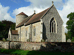 Howe St Mary | |
 Howe Location within Norfolk | |
| Area | 3.20 km2 (1.24 sq mi) |
| Population | 54 |
| • Density | 17/km2 (44/sq mi) |
| OS grid reference | TG275000 |
| Civil parish |
|
| District | |
| Shire county | |
| Region | |
| Country | England |
| Sovereign state | United Kingdom |
| Post town | NORWICH |
| Postcode district | NR15 |
| Police | Norfolk |
| Fire | Norfolk |
| Ambulance | East of England |
Howe, from the Old Norse word haugr, is a Middle English topographic name for someone who lived by a small hill or a man-made mound or barrow. St Mary's church is one of 124 existing round-tower churches in Norfolk, showing many signs of construction in the Anglo-Saxon period, such as tall proportions, splayed porthole windows, and flint quoins. The ample-sized tower dates from the pre-Conquest period, being one of a series of Saxon round towers in Norfolk that demonstrate that the round tower design is at least 1000 years old. Several other features are of interest to the student of local church architecture. The church can be reached from Poringland, approx. 2 km away, along a lane through an open arable field, where another, later, round tower can be seen. There is a regular bus service from Norwich.
Notes edit
- ^ "Howe parish information". South Norfolk Council. 4 January 2006. Archived from the original on 15 October 2008. Retrieved 20 June 2009.
External links edit
![]() Media related to Howe, Norfolk at Wikimedia Commons
Media related to Howe, Norfolk at Wikimedia Commons
- St Mary's on the European Round Tower Churches Website