
KNOWPIA
WELCOME TO KNOWPIA

Humbert, Pas-de-Calais 
Summary
Humbert (French pronunciation: [œ̃bɛʁ]; West Flemish: Humberg) is a commune in the Pas-de-Calais department in the Hauts-de-France region of France.[3]
Humbert
Humberg | |
|---|---|
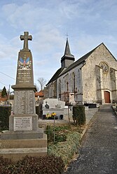 The monument to the dead and church of Humbert | |
 Coat of arms | |
Location of Humbert .mw-parser-output .locmap .od{position:absolute}.mw-parser-output .locmap .id{position:absolute;line-height:0}.mw-parser-output .locmap .l0{font-size:0;position:absolute}.mw-parser-output .locmap .pv{line-height:110%;position:absolute;text-align:center}.mw-parser-output .locmap .pl{line-height:110%;position:absolute;top:-0.75em;text-align:right}.mw-parser-output .locmap .pr{line-height:110%;position:absolute;top:-0.75em;text-align:left}.mw-parser-output .locmap .pv>div{display:inline;padding:1px}.mw-parser-output .locmap .pl>div{display:inline;padding:1px;float:right}.mw-parser-output .locmap .pr>div{display:inline;padding:1px;float:left}html.skin-theme-clientpref-night .mw-parser-output .od,html.skin-theme-clientpref-night .mw-parser-output .od .pv>div,html.skin-theme-clientpref-night .mw-parser-output .od .pl>div,html.skin-theme-clientpref-night .mw-parser-output .od .pr>div{background:#000;color:#fff}html.skin-theme-clientpref-night .mw-parser-output .locmap{filter:grayscale(0.6)}@media(prefers-color-scheme:dark){html.skin-theme-clientpref-os .mw-parser-output .locmap{filter:grayscale(0.6)}html.skin-theme-clientpref-os .mw-parser-output .od,html.skin-theme-clientpref-os .mw-parser-output .od .pv>div,html.skin-theme-clientpref-os .mw-parser-output .od .pl>div,html.skin-theme-clientpref-os .mw-parser-output .od .pr>div{background:#000;color:#fff}}  Humbert  Humbert | |
| Coordinates: 50°30′19″N 1°54′28″E / 50.5053°N 1.9078°E | |
| Country | France |
| Region | Hauts-de-France |
| Department | Pas-de-Calais |
| Arrondissement | Montreuil |
| Canton | Lumbres |
| Intercommunality | CC Haut Pays du Montreuillois |
| Government | |
| • Mayor (2020–2026) | Jean-Claude Avisse[1] |
| Area 1 | 7.85 km2 (3.03 sq mi) |
| Population (2021)[2] | 245 |
| • Density | 31/km2 (81/sq mi) |
| Time zone | UTC+01:00 (CET) |
| • Summer (DST) | UTC+02:00 (CEST) |
| INSEE/Postal code | 62466 /62650 |
| Elevation | 47–147 m (154–482 ft) (avg. 57 m or 187 ft) |
| 1 French Land Register data, which excludes lakes, ponds, glaciers > 1 km2 (0.386 sq mi or 247 acres) and river estuaries. | |
Geography edit
Situated some 8 miles (12 km) northeast of Montreuil-sur-Mer on the D129 road.
Population edit
| Year | Pop. | ±% p.a. |
|---|---|---|
| 1968 | 238 | — |
| 1975 | 225 | −0.80% |
| 1982 | 196 | −1.95% |
| 1990 | 248 | +2.99% |
| 1999 | 254 | +0.27% |
| 2007 | 251 | −0.15% |
| 2012 | 232 | −1.56% |
| 2017 | 232 | +0.00% |
| Source: INSEE[4] | ||
Places of interest edit
- The church of St.Peter, dating from the sixteenth century.
See also edit
References edit
- ^ "Répertoire national des élus: les maires". data.gouv.fr, Plateforme ouverte des données publiques françaises (in French). 2 December 2020.
- ^ "Populations légales 2021". The National Institute of Statistics and Economic Studies. 28 December 2023.
- ^ INSEE commune file
- ^ Population en historique depuis 1968, INSEE
Wikimedia Commons has media related to Humbert (Pas-de-Calais).