


Summary
Humboldt Peak is a high mountain summit of the Crestones in the Sangre de Cristo Range of the Rocky Mountains of North America. The 14,070-foot (4,289 m) fourteener is located in the Sangre de Cristo Wilderness of San Isabel National Forest, 11.9 miles (19.2 km) south-southwest (bearing 204°) of the Town of Westcliffe in Custer County, Colorado, United States.[1][2][3]
| Humboldt Peak | |
|---|---|
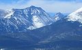
 Humboldt Peak, south aspect | |
| Highest point | |
| Elevation | 14,070 ft (4,289 m)[1][2] |
| Prominence | 1,204 ft (367 m)[2] |
| Isolation | 1.41 mi (2.27 km)[2] |
| Listing | Colorado Fourteener 37th |
| Coordinates | 37°58′34″N 105°33′19″W / 37.9761111°N 105.5552855°W[3] |
| Geography | |
 Humboldt Peak | |
| Location | Custer County, Colorado, U.S.[3] |
| Parent range | Sangre de Cristo Range, Crestones[2] |
| Topo map | USGS 7.5' topographic map Crestone Peak, Colorado[3] |
| Climbing | |
| Easiest route | West Ridge: Hike, class 2[4] |
The Crestones are a cluster of high summits in the Sangre de Cristo Range, comprising Crestone Peak, Crestone Needle, Kit Carson Peak, Challenger Point, Humboldt Peak, and Columbia Point.
The mountain was named in honor of German naturalist and explorer Alexander von Humboldt.[5]
Climbing edit
The standard route on the peak is a hike along a trail, with rock scrambling (Class 2) near the summit. The trail climbs the peak from the South Colony Lakes basin, accessed from the east side of the range. This basin is a popular site that is also the base for most climbs of Crestone Peak and Crestone Needle.
Climate edit
According to the Köppen climate classification system, Humboldt is located in an alpine subarctic climate zone with cold, snowy winters, and cool to warm summers.[6] Due to its altitude, it receives precipitation all year, as snow in winter, and as thunderstorms in summer, with a dry period in late spring.
Gallery edit
-
 Humboldt Peak (left) and Colony Baldy (right)
 -
 In Winter from the northeast


See also edit
References edit
- ^ a b The elevation of Humboldt Peak includes an adjustment of +1.790 m (+5.87 ft) from NGVD 29 to NAVD 88.
- ^ a b c d e "Humboldt Peak, Colorado". Peakbagger.com. Retrieved October 20, 2014.
- ^ a b c d "Humboldt Peak". Geographic Names Information System. United States Geological Survey, United States Department of the Interior. Retrieved October 20, 2014.
- ^ "Humboldt Peak Routes". 14ers.com.
- ^ Eichler, George R. (1977). Colorado Place Names. Boulder, Colorado: Johnson Publishing Company. LCCN 77-089726.
- ^ Peel, M. C.; Finlayson, B. L.; McMahon, T. A. (2007). "Updated world map of the Köppen−Geiger climate classification". Hydrol. Earth Syst. Sci. 11. ISSN 1027-5606.
External links edit
 Definitions from Wiktionary
 Media from Commons
 News from Wikinews
 Quotations from Wikiquote
 Texts from Wikisource
 Textbooks from Wikibooks
 Resources from Wikiversity
- "Humboldt Peak". 14ers.com.