


Summary
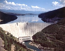
Hungry Horse Dam is an arch dam in the Western United States, on the South Fork Flathead River in the Rocky Mountains of northwest Montana. It is located in Flathead National Forest in Flathead County, about fifteen miles (24 km) south of the west entrance to Glacier National Park, nine miles (14 km) southeast of Columbia Falls, and twenty miles (32 km) northeast of Kalispell. The Hungry Horse project, dam, and powerplant are operated by the U.S. Bureau of Reclamation. The entrance road leading to the dam is located in Hungry Horse.
| Hungry Horse Dam | |
|---|---|
 | |
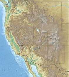 Location in western United States  Location in Montana | |
| Location | Flathead County, near Hungry Horse, Montana, U.S. |
| Coordinates | 48°20′28″N 114°00′50″W / 48.341°N 114.014°W |
| Construction began | April 21, 1948[1] |
| Opening date | July 18, 1953[2] |
| Operator(s) | U.S. Bureau of Reclamation |
| Dam and spillways | |
| Type of dam | Concrete thick arch dam |
| Impounds | South Fork Flathead River |
| Height | 564 ft (172 m)[3] |
| Length | 2,115 ft (645 m)[3] |
| Width (crest) | 34 feet (10.4 m)[3] |
| Width (base) | 320 feet (98 m)[3] |
| Dam volume | 2,934,500 cu yd (2,243,600 m3)[3] |
| Spillway type | Gated Morning Glory[3] |
| Spillway capacity | 50,000 cu ft/s (1,400 m3/s)[3] |
| Reservoir | |
| Creates | Hungry Horse Reservoir[3] |
| Total capacity | 3,467,179 acre-feet (4.28 km3)[3] |
| Catchment area | 1,640 square miles (4,200 km2)[3] |
| Normal elevation | 3,560 feet (1,085 m) above sea level |
| Power Station | |
| Type | Conventional |
| Hydraulic head | 520 ft (160 m)[3] |
| Turbines | 4 x 10⁷ MW Francis turbines[4] |
| Installed capacity | 428 MW[4] |
| Annual generation | 1,086,250,400 KWh (2012)[4] |
The purposes of the Hungry Horse Project authorized by law are irrigation, flood control, navigation, streamflow regulation, hydroelectric generation, and other beneficial uses such as recreation.[2] However, no irrigation facilities were built and the project has no irrigation obligations. Hydroelectric power generation and flood control are the primary purposes of the dam. The dam, reservoir, and surrounding area are used for recreation.
Description edit

At 564 feet (172 m) in height, the dam was the third largest and second highest concrete dam in the world at the time of its completion in 1953,[2] with a volume of 3,100,000 cubic yards (2,400,000 m3).[3] The dam's spillway is the highest morning glory structure in the world.[3] The spillway is controlled by a 64-by-12-foot (19.5 by 3.7 m) ring gate.[1] The surface elevation of the reservoir is 3,560 feet (1,085 m) above sea level.
The dam is managed to provide beneficial flow conditions and to provide safe passage for migrating juvenile fish to reach the Columbia River Estuary and the Pacific Ocean.[5]
History edit

Construction was authorized by the Act of June 5, 1944 (58 Stat. 270, Public Law 78-329). In April 1948, Reclamation awarded the $43.4 million dam construction contract to Morrison-Knudsen, General Construction Company, and Shea Company. The Guy F. Atkinson Company won the contract to divert the river during dam construction. Two timber companies, Wixson and Crowe and J. H. Trisdale, cleared seven thousand acres (2,800 ha) to make way for the reservoir. Construction officially began with a weekend of ceremonies in June 1948. In September 1949, workers poured the first concrete. The project eventually used 3 million cubic yards of concrete. Engineers adopted air-entrained concrete to reduce the effect of freeze-thaw cycles and to make the material more stable and workable. They also incorporated fly ash into the concrete mix. Hungry Horse was the first dam built with these innovations.[6] The construction claimed the lives of 23 men.[7]
Construction was completed on July 18, 1953.[2] At a ceremony on October 1, 1952, President Harry S. Truman threw a switch to start power generation.[8] The road across the dam opened to the public on November 2, 1953.
Hydroelectric power generation edit
The project contributes to hydroelectric power generation not only at Hungry Horse Dam, but by storing and releasing water for use by downriver hydroelectric dams on the Flathead, Clark Fork, Pend Oreille, and Columbia rivers. About a billion kilowatt–hours are generated annually at Hungry Horse Dam, while in an average year the release water will generate about 4.6 billion kilowatt–hours of power as it passes through the series of downstream powerplants.[2]
Power generating facilities at Hungry Horse Dam are housed in a building constructed across the river channel at the downstream toe of the dam. The original design included four 71,250-kilowatt generators—a total of 285 megawatts installed capacity. The generator capacity was uprated in the 1990s to 107,000 kilowatts each for a total capacity of 428 megawatts.[2]
Nearby and downstream, an aluminum production plant was constructed in the mid-1950s, northeast of Columbia Falls.[9]
Tributaries edit
The Hungry Horse Reservoir is fed by a number of smaller creeks and streams, including:
| West side: | East side: |
|---|---|
|
|
See also edit
References edit
- ^ a b Stene, Eric A. "Hungry Horse Project History" (PDF). U.S. Bureau of Reclamation. Retrieved November 1, 2010.
- ^ a b c d e f "Hungry Horse Project". U.S. Bureau of Reclamation. Archived from the original on June 13, 2011. Retrieved November 1, 2010.
- ^ a b c d e f g h i j k l m "Hungry Horse Dam". U.S. Bureau of Reclamation. Archived from the original on June 13, 2011. Retrieved November 1, 2010.
- ^ a b c "Hungry Horse Powerplant". U.S. Bureau of Reclamation. Archived from the original on November 29, 2014. Retrieved November 1, 2010.
- ^ "Federal Columbia River Power System Water Management". NOAA Fisheries. May 10, 2022. Retrieved July 19, 2023.
- ^ Roise, Charlene (Summer 2018). "A Mid-Century Monolith in Northwestern Montana: The Hungry Horse Dam Project". Montana The Magazine of Western History.
- ^ "TRAGEDIES". npshistory.com/. Retrieved July 4, 2019.
- ^ Peters, Gerhard; Woolley, John T. "Address in Montana at the Dedication of the Hungry Horse Dam". The American Presidency Project. UC Santa Barbara. Retrieved November 1, 2021.
- ^ Ruder, Mel (November 14, 1954). "Anaconda aluminum plant past halfway mark". Spokesman-Review. (Spokane, Washington). (photo). p. 27.
External links edit
- U.S. Geological Survey Geographic Names Information System: Hungry Horse Dam
- Historic American Engineering Record (HAER) documentation, filed under South Fork Flathead River, Hungry Horse, Flathead County, MT:
- HAER No. MT-120, "Hungry Horse Dam and Power Plant", 214 photos, 93 data pages, 27 photo caption pages
- HAER No. MT-120-A, "Hungry Horse Dam and Power Plant, Spillway", 12 photos, 8 data pages, 2 photo caption pages
- HAER No. MT-120-B, "Hungry Horse Dam and Power Plant, Outlet Works", 7 photos, 6 data pages, 1 photo caption page
- HAER No. MT-120-C, "Hungry Horse Dam and Power Plant, Warehouse", 10 photos, 3 data pages, 1 photo caption page
- HAER No. MT-120-D, "Hungry Horse Dam and Power Plant, Switchyard", 5 photos, 7 data pages, 1 photo caption page
- HAER No. MT-120-E, "Hungry Horse Dam and Power Plant, Water Tank", 2 photos, 4 data pages, 1 photo caption page
- HAER No. MT-120-F, "Hungry Horse Dam and Power Plant, Retaining Walls", 4 photos, 8 data pages, 1 photo caption page
- HAER No. MT-120-G, "Hungry Horse Dam and Power Plant, Stream Gaging Station", 3 photos, 5 data pages, 1 photo caption page
- HAER No. MT-120-H, "Hungry Horse Dam and Power Plant, Seismic Gaging Station", 4 photos, 8 data pages, 1 photo caption page