


Summary
Hunter Street is a Lower City collector road in Hamilton, Ontario, Canada. It is a one-way street (Westbound) that starts West of Locke Street at Hill Street Park and ends two blocks East of Victoria Avenue at Emerald Street. Hunter Street is a two-way street between Victoria and Emerald Streets.
History edit


Hunter Street is named after Peter Hunter Hamilton (1800–1857), landowner and businessman and half brother of city founder George Hamilton.[1] Originally, sections of Hunter Street were called William Street after King William IV and Peel Street after the British PM, Sir Robert Peel.[2]
Central Public School building on Hunter Street West was built in 1853. This school was built to accommodate 1,000 students, was the largest graded school in Upper Canada, and became the only public school in Hamilton, at the time of its opening in 1853. The building's original final proportioned classical design, by the firm Cumberland & Ridout, was extensively remodelled in 1890 by the Hamilton architect, James Balfour. His alterations, including a steeply pitched roof, certain round arched windows and a heightened central tower, created an edifice in conformity with the late Victorian tastes. The building is designated under the Ontario Heritage Act.
Landmarks edit
Note: Listing of landmarks from West to East.
- Hill Street Park
- Players' Guild of Hamilton, Inc. (theatre)
- Central Public School Building, w/ clock tower
- James Street South Shopping district
- Hamilton GO Transit station, Original site of the Toronto, Hamilton and Buffalo Railway (1892–1987)
- The Fontainebleu (18-storey apartment building)
- Access Community Church of God 7th Day
- Central Memorial Recreation Centre
Communities edit
Note: Listing of neighbourhoods from West to East. [3]
- Kirkendall
- Durand
- Corktown
- Stinson
Roads that are parallel with Hunter Street edit
Lower City roads:
- Burlington Street, West–East
- Barton Street, West/East
- Cannon Street, West/East
- Wilson Street
- King William Street
- King Street, West/East
- Main Street, West/East; - Queenston Road
- Jackson Street, West/East
- Hunter Street, West/East
- Augusta Street
- Charlton Avenue, West/East
- Aberdeen Avenue
Niagara Escarpment (Mountain) Roads:
- Concession Street
- Queensdale Avenue West/ East
- Scenic Drive - Fennell Avenue, West/East
- Sanatorium Road
- Mohawk Road, West/East
- Limeridge Road West/East
- Lincoln M. Alexander Parkway - Mud Street, (Hamilton City Road 11)
- Stone Church Road, West/East
 ; Rymal Road, West/East
- Twenty Road
Roads that cross Hunter Street edit


Note: Listing of streets from West to East.
- Locke Street, South
- Queen Street, South
- Hess Street, South
- Caroline Street, South
- Bay Street, South
- MacNab Street, South
- James Street, South
- Hughson Street, South
- John Street, South
- Catharine Street, South
- Ferguson Avenue, South
- Wellington Street, South
- Victoria Avenue, South
Images edit
-
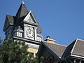 Central Public School building, Hunter Street West
 -
 Central Public School building, Front Entrance, Hunter Street West
 -
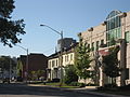 Hunter Street East
 -
 Hunter Street East, looking West
 -
 Corner of Hunter and James Streets
 -
 Corner of Hunter and James Streets
 -
 Back of City Hall, View from Hunter Street West
 -
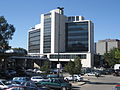
 Downtown Hamilton, View from Hunter Street West


References edit
- ^ Bailey, Thomas Melville (1981). Dictionary of Hamilton Biography (Vol I, 1791-1875). W.L. Griffin Ltd.
- ^ Manson, Bill (2003). Footsteps In Time: Exploring Hamilton's heritage neighbourhoods. North Shore Publishing Inc. ISBN 1-896899-22-6.
- ^ "Hamilton Neighbourhood Boundaries, (map.hamilton.ca)" (PDF). Archived from the original (PDF) on 2007-09-27. Retrieved 2007-05-11.
- MapArt Golden Horseshoe Atlas - page 647 - Grids H10, H11, H12, H13
External links edit
- Downtown Hamilton
- Durand Neighbourhood
- Kirkendall Neighbourhood
- Locke Street.com
- Locke Street South Shopping District
- Google Maps: Hunter Street (Hybrid)