


Summary
Hutchesontown is an inner-city area in Glasgow, Scotland. Mostly residential, it is situated directly south of the River Clyde and forms part of the wider historic Gorbals district, which is covered by the Southside Central ward under Glasgow City Council.
Hutchesontown
| |
|---|---|
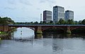
 Aerial photo of Hutchesontown on the south bank of the River Clyde (with Calton and Glasgow Green on the north bank) | |
 Hutchesontown Location within Glasgow | |
| OS grid reference | NS594636 |
| Council area | |
| Lieutenancy area |
|
| Country | Scotland |
| Sovereign state | United Kingdom |
| Post town | GLASGOW |
| Postcode district | G5 0 |
| Dialling code | 0141 |
| Police | Scotland |
| Fire | Scottish |
| Ambulance | Scottish |
| UK Parliament | |
| Scottish Parliament | |
The area is linked to Glasgow Green public park on the north side of the river by St. Andrew's Suspension Bridge and King's Bridge. At its north-western edge, Albert Bridge is the closest crossing point towards Glasgow city centre. In McNeill Street, Hutchesontown has one of Glasgow's original Carnegie libraries, deftly designed by the Inverness-born architect James Robert Rhind. James Stokes, recipient of the Victoria Cross, was from the area.
Comprehensive Development Area edit
Following the Second World War, Hutchesontown was declared a Comprehensive Development Area (CDA) in 1957, in the aftermath of the Bruce Report.[1][2] This called for the mass gentrification of the area which took the form of slum clearance and the replacement of overcrowded, insanitary tenement housing with new homes in high rise tower blocks.[3] The area became almost unrecognisable from its previous appearance, with blocks of tenements swept away along with several Victorian and Edwardian-era churches and civic buildings which in later times would have been considered to be of architectural merit.[4]
Hutchesontown was, in effect, used as a testing ground for similar schemes around the city. It was decided to divide the area into five "zones" which were given to different architects to implement a mixture of different schemes.
- Area A – on the northern side of the CDA was devoted to conventional maisonette style housing - today close to the Gorbals Health Centre and Gorbals Sports Centre.[4]
- Area B – nowadays known as the Riverside estate, was assigned to architect Robert Matthew (RMJM). The four 18-storey blocks[5][6] – built in 1964 to the distinctive "scissor section" configuration – on the banks of the River Clyde still stand, and are widely regarded as the most successful of the Gorbals high-rises and have received numerous refurbishments in their lifetime.[4][3] The Strathclyde Grain distillery lies directly to the east. After the scheduled demolition of the two remaining Area D towers (see below), these will be the only remaining high rise blocks in the Gorbals.
- Area C – was the responsibility of Basil Spence, and became the most infamous of the five schemes.[7][6] The Queen Elizabeth Square blocks encountered numerous structural and social problems, and were demolished in 1993.[4][8][9]
- Area D – in the south of the CDA was developed by the newly created Scottish Special Housing Association[10] and consisted of four 24 storey blocks at Caledonia Road (the main bus route through the area between Glasgow and Rutherglen) and an estate of smaller maisonettes and 8-storey "mini-multis".[11][6][3] Two of the towers were demolished in early 2006;[12] the remaining two were refurbished, but in 2020 it was confirmed that they too would be demolished in the near future due to issues with the cladding that was applied in the previous work and the prohibitive cost of remedying these faults.[13][14] This sector is close to the Oatlands neighbourhood, the Southern Necropolis cemetery[4] and the 'Dixon's Blazes' industrial estate.
- Area E – closest to Gorbals Cross and Laurieston, consisted of an estate of five-storey deck-access blocks and two 24-storey towers at Sandiefield Road, constructed in 1968.[15][6][3] Within a few years, however, the low-rise buildings became badly affected by dampness and condensation problems[16] and were presently declared unfit for habitation; they were finally demolished in 1987.[17] The two towers were condemned in 2010 and were demolished at 14:00 on 21 July 2013.[4][18]
Gallery edit
-
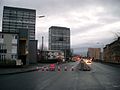
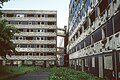
 River Clyde and Waddell Court towers ('Hutchie B'), 2009
 -
 Ballater Street, 2009
 -
 Waddell Street, 2013
 -
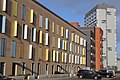
 Modern apartments on the site of Queen Elizabeth Square
 -
 19th-century St Francis Church, in 'Hutchie C' area but spared from the wrecking ball, now a community centre, 2012
 -
 Caledonia Road towers ('Hutchie D'), 2005, shortly before the demolition of two (right)
 -
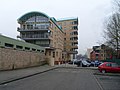
 Gorbals Training Centre, McNeill Street (formerly Hutchesontown Library), 2013
 -
 Sandiefield Road towers ('Hutchie E'), 2011
 -
 Low-rise Area "E" flats in 1987, shortly prior to demolition


See also edit
References edit
- ^ Hutchesontown Housing (Glasgow City Archives, Department of Architectural and Civic Design, 1961), The Glasgow Story
- ^ Lecture: Unbuilt Glasgow – The History & Impact of the Bruce Report, Fergus Sutherland & David Martin, Glasgow City Heritage Trust, 15 March 2017
- ^ a b c d Hutchesontown: Housing, Everyday Life & Wellbeing over the long term, University of Glasgow
- ^ a b c d e f Hutchesontown Gorbals - Architecture and History, Scotcities
- ^ "Tower Block UK: Hutchesontown-Gorbals CDA Area B". University of Edinburgh. Retrieved 13 January 2019.
- ^ a b c d "Buildings in Glasgow: Hutchesontown-Gorbals". Emporis. Archived from the original on 28 February 2019. Retrieved 27 February 2019.
- ^ "Tower Block UK: Hutchesontown-Gorbals CDA Area C". University of Edinburgh. Retrieved 13 January 2019.
- ^ "Woman dies in demolition blast". The Herald. 13 September 1993. Retrieved 17 February 2019.
- ^ Hutchesontown C: it went down with a bang and took a human life with it, Abandoned Spaces, 4 June 2018
- ^ Hutchesontown / Gorbals Area D, Dictionary of Scottish Architects
- ^ "Tower Block UK: Hutchesontown-Gorbals CDA Area D". University of Edinburgh. Retrieved 13 January 2019.
- ^ "Two tower blocks are demolished". BBC News. 26 February 2006. Retrieved 17 February 2019.
- ^ 'I won't let them split us up': Friend's promise to Gorbals neighbour as demolition looms, Glasgow Times, 26 November 2020
- ^ Glasgow high-rise tenants being moved from fire-risk flats set to get new homes, Glasgow Live, 22 November 2021
- ^ "Tower Block UK: Hutchesontown-Gorbals CDA Area E". University of Edinburgh. Retrieved 13 January 2019.
- ^ McLean, David (13 April 2022). "The notoriously dire Gorbals flats that locals dubbed 'The Dampies'". GlasgowLive. Retrieved 26 July 2023.
- ^ Wright, Valerie (December 2021). "'Housing Problems … are Political Dynamite': Housing Disputes in Glasgow c. 1971 to the Present Day". Sociological Research Online. 26 (4): 976–988. doi:10.1177/1360780418780038. hdl:1893/30642.
- ^ Double demolition for Glasgow Gorbals tower blocks, BBC News, 21 July 2013
External links edit
- Greater Gorbals, socio-economic profile at Understanding Glasgow (2012)
- Hutchesontown - Illustrated Guide