
KNOWPIA
WELCOME TO KNOWPIA

Ibarrolle 
Summary
Ibarrolle (French pronunciation: [ibaʁɔl]; Basque: Ibarrola)[3] is a commune in the Pyrénées-Atlantiques department in south-western France.
Ibarrolle
Ibarrola | |
|---|---|
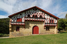 The Etxepare farmhouse | |
 Coat of arms | |
Location of Ibarrolle .mw-parser-output .locmap .od{position:absolute}.mw-parser-output .locmap .id{position:absolute;line-height:0}.mw-parser-output .locmap .l0{font-size:0;position:absolute}.mw-parser-output .locmap .pv{line-height:110%;position:absolute;text-align:center}.mw-parser-output .locmap .pl{line-height:110%;position:absolute;top:-0.75em;text-align:right}.mw-parser-output .locmap .pr{line-height:110%;position:absolute;top:-0.75em;text-align:left}.mw-parser-output .locmap .pv>div{display:inline;padding:1px}.mw-parser-output .locmap .pl>div{display:inline;padding:1px;float:right}.mw-parser-output .locmap .pr>div{display:inline;padding:1px;float:left}html.skin-theme-clientpref-night .mw-parser-output .od,html.skin-theme-clientpref-night .mw-parser-output .od .pv>div,html.skin-theme-clientpref-night .mw-parser-output .od .pl>div,html.skin-theme-clientpref-night .mw-parser-output .od .pr>div{background:#000;color:#fff}html.skin-theme-clientpref-night .mw-parser-output .locmap{filter:grayscale(0.6)}@media(prefers-color-scheme:dark){html.skin-theme-clientpref-os .mw-parser-output .locmap{filter:grayscale(0.6)}html.skin-theme-clientpref-os .mw-parser-output .od,html.skin-theme-clientpref-os .mw-parser-output .od .pv>div,html.skin-theme-clientpref-os .mw-parser-output .od .pl>div,html.skin-theme-clientpref-os .mw-parser-output .od .pr>div{background:#000;color:#fff}}  Ibarrolle  Ibarrolle | |
| Coordinates: 43°12′03″N 1°05′38″W / 43.2008°N 1.0939°W | |
| Country | France |
| Region | Nouvelle-Aquitaine |
| Department | Pyrénées-Atlantiques |
| Arrondissement | Bayonne |
| Canton | Pays de Bidache, Amikuze et Ostibarre |
| Intercommunality | Pays Basque |
| Government | |
| • Mayor (2020–2026) | Dominique Poydessus[1] |
| Area 1 | 8.87 km2 (3.42 sq mi) |
| Population (2021)[2] | 73 |
| • Density | 8.2/km2 (21/sq mi) |
| Time zone | UTC+01:00 (CET) |
| • Summer (DST) | UTC+02:00 (CEST) |
| INSEE/Postal code | 64267 /64120 |
| Elevation | 159–764 m (522–2,507 ft) (avg. 160 m or 520 ft) |
| 1 French Land Register data, which excludes lakes, ponds, glaciers > 1 km2 (0.386 sq mi or 247 acres) and river estuaries. | |
It is located in the former province of Lower Navarre.[3]
Population edit
| Year | Pop. | ±% p.a. |
|---|---|---|
| 1968 | 110 | — |
| 1975 | 101 | −1.21% |
| 1982 | 91 | −1.48% |
| 1990 | 92 | +0.14% |
| 1999 | 88 | −0.49% |
| 2007 | 97 | +1.22% |
| 2012 | 95 | −0.42% |
| 2017 | 82 | −2.90% |
| Source: INSEE[4] | ||
See also edit
References edit
- ^ "Répertoire national des élus: les maires". data.gouv.fr, Plateforme ouverte des données publiques françaises (in French). 9 August 2021.
- ^ "Populations légales 2021". The National Institute of Statistics and Economic Studies. 28 December 2023.
- ^ a b IBARROLA, Auñamendi Eusko Entziklopedia (in Spanish)
- ^ Population en historique depuis 1968, INSEE
Wikimedia Commons has media related to Ibarrolle.