
KNOWPIA
WELCOME TO KNOWPIA

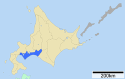
Iburi Subprefecture 
Summary
Iburi Subprefecture (胆振総合振興局, Iburi-sōgō-shinkō-kyoku) is a subprefecture of Hokkaido Prefecture, Japan.
Iburi Subprefecture
胆振総合振興局 | |
|---|---|
| Iburi-sōgō-shinkō-kyoku | |
 | |
| Prefecture | Hokkaido |
| Capital | Muroran |
| Area | |
| • Total | 3,698.00 km2 (1,427.81 sq mi) |
| Population (March 2009) | |
| • Total | 426,627 |
| • Density | 120/km2 (300/sq mi) |
| Website | iburi.pref.hokkaido.lg.jp |

Iburi Subprefecture


Geography edit
Located in south-central Hokkaido, Iburi stretches 152 kilometres (94 mi) East-West and 98 kilometres (61 mi) North-South. Iburi covers an area of 9,698 square kilometres (3,744 sq mi). Iburi borders Oshima Subprefecture to the West, Shiribeshi, Ishikari, and Sorachi Subprefectures to the North, and Hidaka Subprefecture to the East. On its South side, Iburi has 218 kilometres (135 mi) of coastline with the Pacific Ocean.[1]
Municipalities edit
| Name | Area (km2) | Population | District | Type | Map | |
|---|---|---|---|---|---|---|
| Rōmaji | Kanji | |||||
| 安平町 | 237.13 | 8,323 | Yūfutsu District | Town | 
| |
| 厚真町 | 404.56 | 4,659 | Yūfutsu District | Town | 
| |
| 伊達市 | 444.28 | 34,898 | no district | City | 
| |
| むかわ町 | 166.43 | 8,527 | Yūfutsu District | Town | 
| |
| 室蘭市 | 80.65 | 93,716 | no district | City | 
| |
| 登別市 | 212.11 | 49,523 | no district | City | 
| |
| 白老町 | 425.75 | 17,759 | Shiraoi District | Town | 
| |
| 壮瞥町 | 205.04 | 2,665 | Usu District | Town | 
| |
| 苫小牧市 | 561.49 | 174,216 | no district | City | 
| |
| 洞爺湖町 | 180.54 | 9,231 | Abuta District | Town | 
| |
| 豊浦町 | 233.54 | 4,205 | Abuta District | Town | 
| |
Mergers edit
History edit
- 1897: Muroran Subprefecture was established.
- 1922: Muroran Subprefecture was renamed Iburi Subprefecture.
References edit
- ^ 胆振の概要 (in Japanese). Hokkaido Government Iburi Subprefectural Office. 2006. Archived from the original on 2008-06-20. Retrieved 2008-06-19.
External links edit
- Official website (in Japanese)