


Summary
In glaciology, an ice sheet, also known as a continental glacier,[2] is a mass of glacial ice that covers surrounding terrain and is greater than 50,000 km2 (19,000 sq mi).[3] The only current ice sheets are the Antarctic ice sheet and the Greenland ice sheet. Ice sheets are bigger than ice shelves or alpine glaciers. Masses of ice covering less than 50,000 km2 are termed an ice cap. An ice cap will typically feed a series of glaciers around its periphery.

Although the surface is cold, the base of an ice sheet is generally warmer due to geothermal heat. In places, melting occurs and the melt-water lubricates the ice sheet so that it flows more rapidly. This process produces fast-flowing channels in the ice sheet — these are ice streams.
In previous geologic time spans (glacial periods) there were other ice sheets. During the Last Glacial Period at Last Glacial Maximum, the Laurentide Ice Sheet covered much of North America. In the same period, the Weichselian ice sheet covered Northern Europe and the Patagonian Ice Sheet covered southern South America.
Overview edit
An ice sheet is a body of ice which covers a land area of continental size - meaning that it exceeds 50,000 km2.[4] The currently existing two ice sheets in Greenland and Antarctica have a much greater area than this minimum definition, measuring at 1.7 million km2 and 14 million km2, respectively. Both ice sheets are also very thick, as they consist of a continuous ice layer with an average thickness of 2 km (1 mi).[1][5] This ice layer forms because most of the snow which falls onto the ice sheet never melts, and is instead compressed by the mass of newer snow layers.[4]
This process of ice sheet growth is still occurring nowadays, as can be clearly seen in an example that occurred in World War II. A Lockheed P-38 Lightning fighter plane crashed in Greenland in 1942. It was only recovered 50 years later. By then, it had been buried under 81 m (268 feet) of ice which had formed over that time period.[6]
Dynamics edit
Glacial flows edit
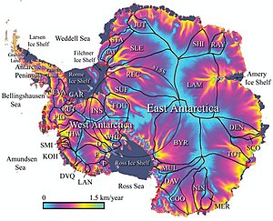
Even stable ice sheets are continually in motion as the ice gradually flows outward from the central plateau, which is the tallest point of the ice sheet, and towards the margins. The ice sheet slope is low around the plateau but increases steeply at the margins.[4] This difference in slope occurs due to an imbalance between high ice accumulation in the central plateau and lower accumulation, as well as higher ablation, at the margins. This imbalance increases the shear stress on a glacier until it begins to flow. The flow velocity and deformation will increase as the equilibrium line between these two processes is approached.[7][8] This motion is driven by gravity but is controlled by temperature and the strength of individual glacier bases. A number of processes alter these two factors, resulting in cyclic surges of activity interspersed with longer periods of inactivity, on time scales ranging from hourly (i.e. tidal flows) to the centennial (Milankovich cycles).[8]
On an hour-to-hour basis, surges of ice motion can be modulated by tidal activity. The influence of a 1 m tidal oscillation can be felt as much as 100 km from the sea.[9] During larger spring tides, an ice stream will remain almost stationary for hours at a time, before a surge of around a foot in under an hour, just after the peak high tide; a stationary period then takes hold until another surge towards the middle or end of the falling tide.[10][11] At neap tides, this interaction is less pronounced, and surges instead occur approximately every 12 hours.[10]
Increasing global air temperatures due to climate change take around 10,000 years to directly propagate through the ice before they influence bed temperatures, but may have an effect through increased surface melting, producing more supraglacial lakes. These lakes may feed warm water to glacial bases and facilitate glacial motion.[12] Lakes of a diameter greater than ~300 m are capable of creating a fluid-filled crevasse to the glacier/bed interface. When these crevasses form, the entirety of the lake's (relatively warm) contents can reach the base of the glacier in as little as 2–18 hours – lubricating the bed and causing the glacier to surge.[13] Water that reaches the bed of a glacier may freeze there, increasing the thickness of the glacier by pushing it up from below.[14]
Boundary conditions edit

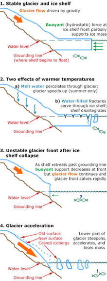
As the margins end at the marine boundary, excess ice is discharged through ice streams or outlet glaciers. Then, it either falls directly into the sea or is accumulated atop the floating ice shelves.[4]: 2234 Those ice shelves then calve icebergs at their periphery if they experience excess of ice. Ice shelves would also experience accelerated calving due to basal melting. In Antarctica, this is driven by heat fed to the shelf by the circumpolar deep water current, which is 3 °C above the ice's melting point.[15]
The presence of ice shelves has a stabilizing influence on the glacier behind them, while an absence of an ice shelf becomes destabilizing. For instance, when Larsen B ice shelf in the Antarctic Peninsula had collapsed over three weeks in February 2002, the four glaciers behind it - Crane Glacier, Green Glacier, Hektoria Glacier and Jorum Glacier - all started to flow at a much faster rate, while the two glaciers (Flask and Leppard) stabilized by the remnants of the ice shelf did not accelerate.[16] The collapse of the Larsen B shelf was preceded by thinning of just 1 metre per year, while some other Antarctic ice shelves have displayed thinning of tens of metres per year.[12] Further, increased ocean temperatures of 1 °C may lead to up to 10 metres per year of basal melting.[12] Ice shelves are always stable under mean annual temperatures of −9 °C, but never stable above −5 °C; this places regional warming of 1.5 °C, as preceded the collapse of Larsen B, in context.[12]
Marine ice sheet instability edit
In the 1970s, Johannes Weertman proposed that because seawater is denser than ice, then any ice sheets grounded below sea level inherently become less stable as they melt due to Archimedes' principle.[17] Effectively, these marine ice sheets must have enough mass to exceed the mass of the seawater displaced by the ice, which requires excess thickness. As the ice sheet melts and becomes thinner, the weight of the overlying ice decreases. At a certain point, sea water could force itself into the gaps which form at the base of the ice sheet, and marine ice sheet instability (MISI) would occur.[17][18]
Even if the ice sheet is grounded below the sea level, MISI cannot occur as long as there is a stable ice shelf in front of it.[19] The boundary between the ice sheet and the ice shelf, known as the grounding line, is particularly stable if it is constrained in an embayment.[19] In that case, the ice sheet may not be thinning at all, as the amount of ice flowing over the grounding line would be likely to match the annual accumulation of ice from snow upstream.[18] Otherwise, ocean warming at the base of an ice shelf tends to thin it through basal melting. As the ice shelf becomes thinner, it exerts less of an buttressing effect on the ice sheet, the so-called back stress increases and the grounding line is pushed backwards.[18] The ice sheet is likely to start losing more ice from the new location of the grounding line and so become lighter and less capable of displacing seawater. This eventually pushes the grounding line back even further, creating a self-reinforcing mechanism.[18][20]
Vulnerable locations edit

Because the entire West Antarctic Ice Sheet is grounded below the sea level, it would be vulnerable to geologically rapid ice loss in this scenario.[22][23] In particular, the Thwaites and Pine Island glaciers are most likely to be prone to MISI, and both glaciers have been rapidly thinning and accelerating in recent decades.[24][25][26][27] As the result, sea level rise from the ice sheet could be accelerated by tens of centimeters within the 21st century alone.[28]
The majority of the East Antarctic Ice Sheet would not be affected. Totten Glacier is the largest glacier there which is known to be subject to MISI - yet, its potential contribution to sea level rise is comparable to that of the entire West Antarctic Ice Sheet.[29] Totten Glacier has been losing mass nearly monotonically in recent decades,[30] suggesting rapid retreat is possible in the near future, although the dynamic behavior of Totten Ice Shelf is known to vary on seasonal to interannual timescales.[31][32][33] The Wilkes Basin is the only major submarine basin in Antarctica that is not thought to be sensitive to warming.[26] Ultimately, even geologically rapid sea level rise would still most likely require several millennia for the entirety of these ice masses (WAIS and the subglacial basins) to be lost.[34][35]
Marine Ice Cliff Instability edit
A related process known as Marine Ice Cliff Instability (MICI) posits that due to the physical characteristics of ice, subaerial ice cliffs exceeding ~90 meters in height are likely to collapse under their own weight, and this could lead to self-sustaining ice sheet retreat.[18] It is thought to occur when an ice sheet grounded below sea level with an inland-sloping bed has exposed ice cliffs after the removal of peripheral ice. The tall cliffs, exposed to hydrofracturing forces and without buttressing, are structurally unstable due to their mass, and their collapse is thought to then expose the ice behind it to the same instability, resulting in a cycle of cliff collapse. Surface melt can further enhance MICI through ponding and hydrofracture.[19][36] However, this theory is controversial, and has never been directly observed in the present, only in geological records.[37] Recent research has highlighted the importance of glacial geometry in causing or preventing marine ice cliff instability, suggesting that buttressing ice cliffs might be a way to prevent their collapse.[38][39]
Earth's current two ice sheets edit
Antarctic ice sheet edit
West Antarctic ice sheet edit
| West Antarctic ice sheet | |
|---|---|
 | |
| Type | Ice sheet |
| Area | <1,970,000 km2 (760,000 sq mi)[40] |
| Thickness | ~1.05 km (0.7 mi) (average),[41] ~2 km (1.2 mi) (maximum)[40] |
| Status | Receding |
The West Antarctic Ice Sheet (WAIS) is the segment of the continental ice sheet that covers West Antarctica, the portion of Antarctica on the side of the Transantarctic Mountains that lies in the Western Hemisphere. It is classified as a marine-based ice sheet, meaning that its bed lies well below sea level and its edges flow into floating ice shelves. The WAIS is bounded by the Ross Ice Shelf, the Ronne Ice Shelf, and outlet glaciers that drain into the Amundsen Sea.[42]
As a smaller part of Antarctica, WAIS is also more strongly affected by climate change. There has been warming over the ice sheet since the 1950s,[43][44] and a substantial retreat of its coastal glaciers since at least the 1990s.[45] Estimates suggest it added around 7.6 ± 3.9 mm (19⁄64 ± 5⁄32 in) to the global sea level rise between 1992 and 2017,[46] and has been losing ice in the 2010s at a rate equivalent to 0.4 millimetres (0.016 inches) of annual sea level rise.[47] While some of its losses are offset by the growth of East Antarctic ice sheet, Antarctica as a whole will most likely lose enough ice by 2100 to add 11 cm (4.3 in) to sea levels. Further, marine ice sheet instability may increase this amount by tens of centimeters, particularly under high warming.[48] Fresh meltwater from WAIS also contributes to ocean stratification and dilutes the formation of salty Antarctic bottom water, which destabilizes Southern Ocean overturning circulation.[48][49][50]
In the long term, the West Antarctic Ice Sheet is likely to disappear due to the warming which has already occurred.[51] Paleoclimate evidence suggests that this has already happened during the Eemian period, when the global temperatures were similar to the early 21st century.[52][53] It is believed that the loss of the ice sheet would take place between 2,000 and 13,000 years,[54][55] although several centuries of high emissions may shorten this to 500 years.[56] 3.3 m (10 ft 10 in) of sea level rise would occur if the ice sheet collapses but leaves ice caps on the mountains behind. Total sea level rise from West Antarctica increases to 4.3 m (14 ft 1 in) if they melt as well,[57] but this would require a higher level of warming.[58] Isostatic rebound of ice-free land may also add around 1 m (3 ft 3 in) to the global sea levels over another 1,000 years.[56]
The preservation of WAIS may require a persistent reduction of global temperatures to 1 °C (1.8 °F) below the preindustrial level, or to 2 °C (3.6 °F) below the temperature of 2020.[59] Because the collapse of the ice sheet would be preceded by the loss of Thwaites Glacier and Pine Island Glacier, some have instead proposed interventions to preserve them. In theory, adding thousands of gigatonnes of artificially created snow could stabilize them,[60] but it would be extraordinarily difficult and may not account for the ongoing acceleration of ocean warming in the area.[51] Others suggest that building obstacles to warm water flows beneath glaciers would be able to delay the disappearance of the ice sheet by many centuries, but it would still require one of the largest civil engineering interventions in history.East Antarctic ice sheet edit
| East Antarctic ice sheet | |
|---|---|
 | |
| Type | Ice sheet |
| Thickness | ~2.2 km (1.4 mi) (average),[61] ~4.9 km (3.0 mi) (maximum) [62] |
The East Antarctic Ice Sheet (EAIS) lies between 45° west and 168° east longitudinally. It was first formed around 34 million years ago,[63] and it is the largest ice sheet on the entire planet, with far greater volume than the Greenland ice sheet or the West Antarctic Ice Sheet (WAIS), from which it is separated by the Transantarctic Mountains. The ice sheet is around 2.2 km (1.4 mi) thick on average and is 4,897 m (16,066 ft) at its thickest point.[64] It is also home to the geographic South Pole, South Magnetic Pole and the Amundsen–Scott South Pole Station.
The surface of the EAIS is the driest, windiest, and coldest place on Earth. Lack of moisture in the air, high albedo from the snow as well as the surface's consistently high elevation[65] results in the reported cold temperature records of nearly −100 °C (−148 °F).[66][67] It is the only place on Earth cold enough for atmospheric temperature inversion to occur consistently. That is, while the atmosphere is typically warmest near the surface and becomes cooler at greater elevation, atmosphere during the Antarctic winter is cooler at the surface than in its middle layers. Consequently, greenhouse gases actually trap heat in the middle atmosphere and reduce its flow towards the surface while the temperature inversion lasts.[65]
Due to these factors, East Antarctica had experienced slight cooling for decades while the rest of the world warmed as the result of climate change. Clear warming over East Antarctica only started to occur since the year 2000, and was not conclusively detected until the 2020s.[68][69] In the early 2000s, cooling over East Antarctica seemingly outweighing warming over the rest of the continent was frequently misinterpreted by the media and occasionally used as an argument for climate change denial.[70][71][72] After 2009, improvements in Antarctica's instrumental temperature record have proven that the warming over West Antarctica resulted in consistent net warming across the continent since the 1957.[73]
Because the East Antarctic ice sheet has barely warmed, it is still gaining ice on average.[74][75] for instance, GRACE satellite data indicated East Antarctica mass gain of 60 ± 13 billion tons per year between 2002 and 2010.[76] It is most likely to first see sustained losses of ice at its most vulnerable locations such as Totten Glacier and Wilkes Basin. Those areas are sometimes collectively described as East Antarctica's subglacial basins, and it is believed that once the warming reaches around 3 °C (5.4 °F), then they would start to collapse over a period of around 2,000 years,[77][78] This collapse would ultimately add between 1.4 m (4 ft 7 in) and 6.4 m (21 ft 0 in) to sea levels, depending on the ice sheet model used.[79] The EAIS as a whole holds enough ice to raise global sea levels by 53.3 m (175 ft).[64] However, it would take global warming in a range between 5 °C (9.0 °F) and 10 °C (18 °F), and a minimum of 10,000 years for the entire ice sheet to be lost.[77][78]Greenland ice sheet edit
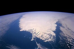
The Greenland ice sheet is an ice sheet which forms the second largest body of ice in the world. It is an average of 1.67 km (1.0 mi) thick, and over 3 km (1.9 mi) thick at its maximum.[80] It is almost 2,900 kilometres (1,800 mi) long in a north–south direction, with a maximum width of 1,100 kilometres (680 mi) at a latitude of 77°N, near its northern edge.[81] The ice sheet covers 1,710,000 square kilometres (660,000 sq mi), around 80% of the surface of Greenland, or about 12% of the area of the Antarctic ice sheet.[80] The term 'Greenland ice sheet' is often shortened to GIS or GrIS in scientific literature.[82][83][84][85]
Greenland has had major glaciers and ice caps for at least 18 million years,[86] but a single ice sheet first covered most of the island some 2.6 million years ago.[87] Since then, it has both grown[88][89] and contracted significantly.[90][91][92] The oldest known ice on Greenland is about 1 million years old.[93] Due to anthropogenic greenhouse gas emissions, the ice sheet is now the warmest it has been in the past 1000 years,[94] and is losing ice at the fastest rate in at least the past 12,000 years.[95]
Every summer, parts of the surface melt and ice cliffs calve into the sea. Normally the ice sheet would be replenished by winter snowfall,[83] but due to global warming the ice sheet is melting two to five times faster than before 1850,[96] and snowfall has not kept up since 1996.[97] If the Paris Agreement goal of staying below 2 °C (3.6 °F) is achieved, melting of Greenland ice alone would still add around 6 cm (2+1⁄2 in) to global sea level rise by the end of the century. If there are no reductions in emissions, melting would add around 13 cm (5 in) by 2100,[98]: 1302 with a worst-case of about 33 cm (13 in).[99] For comparison, melting has so far contributed 1.4 cm (1⁄2 in) since 1972,[100] while sea level rise from all sources was 15–25 cm (6–10 in)) between 1901 and 2018.[101]: 5
Carbon cycle edit

Estimated carbon fluxes are measured in Tg C a−1 (megatonnes of carbon per year) and estimated sizes of carbon stores are measured in Pg C (thousands of megatonnes of carbon). DOC = dissolved organic carbon, POC = particulate organic carbon.[105]
Historically, ice sheets were viewed as inert components of the carbon cycle and were largely disregarded in global models. In 2010s, research had demonstrated the existence of uniquely adapted microbial communities, high rates of biogeochemical/physical weathering in ice sheets and storage and cycling of organic carbon in excess of 100 billion tonnes.[105] There is a massive hemispheric contrast in carbon storage between the two ice sheets. While only about 0.5-27 billion tonnes of pure carbon are present underneath the Greenland ice sheet, 6000-21,000 billion tonnes are thought to be located underneath Antarctica.[105]
For comparison, 1400–1650 billion tonnes are contained within the Arctic permafrost,[106] while the annual anthropogenic emissions amount to around 40 billion tonnes of CO2.[28]: 1237 ) This carbon can act as a climate change feedback if it is gradually released through meltwater, thus increasing overall carbon dioxide emissions.[107]
In Greenland, there is one known area, at Russell Glacier, where meltwater carbon is released into the atmosphere as methane, which has a much larger global warming potential than carbon dioxide:[108] however, it also harbours large numbers of methanotrophic bacteria, which limit those emissions.[109][110]
In geologic timescales edit

Normally, the transitions between glacial and interglacial states are governed by Milankovitch cycles, which are patterns in insolation (the amount of sunlight reaching the Earth). These patterns are caused by the variations in shape of the Earth's orbit and its angle relative to the Sun, caused by the gravitational pull of other planets as they go through their own orbits.[112][113]
For instance, during at least the last 100,000 years, portions of the ice sheet covering much of North America, the Laurentide Ice Sheet broke apart sending large flotillas of icebergs into the North Atlantic. When these icebergs melted they dropped the boulders and other continental rocks they carried, leaving layers known as ice rafted debris. These so-called Heinrich events, named after their discoverer Hartmut Heinrich, appear to have a 7,000–10,000-year periodicity, and occur during cold periods within the last interglacial.[114]
Internal ice sheet "binge-purge" cycles may be responsible for the observed effects, where the ice builds to unstable levels, then a portion of the ice sheet collapses. External factors might also play a role in forcing ice sheets. Dansgaard–Oeschger events are abrupt warmings of the northern hemisphere occurring over the space of perhaps 40 years. While these D–O events occur directly after each Heinrich event, they also occur more frequently – around every 1500 years; from this evidence, paleoclimatologists surmise that the same forcings may drive both Heinrich and D–O events.[115]
Hemispheric asynchrony in ice sheet behavior has been observed by linking short-term spikes of methane in Greenland ice cores and Antarctic ice cores. During Dansgaard–Oeschger events, the northern hemisphere warmed considerably, dramatically increasing the release of methane from wetlands, that were otherwise tundra during glacial times. This methane quickly distributes evenly across the globe, becoming incorporated in Antarctic and Greenland ice. With this tie, paleoclimatologists have been able to say that the ice sheets on Greenland only began to warm after the Antarctic ice sheet had been warming for several thousand years. Why this pattern occurs is still open for debate.[116][117]
Antarctic ice sheet during geologic timescales edit

The icing of Antarctica began in the Late Palaeocene or middle Eocene between 60[118] and 45.5 million years ago[119] and escalated during the Eocene–Oligocene extinction event about 34 million years ago. CO2 levels were then about 760 ppm[120] and had been decreasing from earlier levels in the thousands of ppm. Carbon dioxide decrease, with a tipping point of 600 ppm, was the primary agent forcing Antarctic glaciation.[121] The glaciation was favored by an interval when the Earth's orbit favored cool summers but oxygen isotope ratio cycle marker changes were too large to be explained by Antarctic ice-sheet growth alone indicating an ice age of some size.[122] The opening of the Drake Passage may have played a role as well[123] though models of the changes suggest declining CO2 levels to have been more important.[124]
The Western Antarctic ice sheet declined somewhat during the warm early Pliocene epoch, approximately five to three million years ago; during this time the Ross Sea opened up.[125] But there was no significant decline in the land-based Eastern Antarctic ice sheet.[126]Greenland ice sheet during geologic timescales edit

While there is evidence of large glaciers in Greenland for most of the past 18 million years,[86] these ice bodies were probably similar to various smaller modern examples, such as Maniitsoq and Flade Isblink, which cover 76,000 and 100,000 square kilometres (29,000 and 39,000 sq mi) around the periphery. Conditions in Greenland were not initially suitable for a single coherent ice sheet to develop, but this began to change around 10 million years ago, during the middle Miocene, when the two passive continental margins which now form the uplands of West and East Greenland experienced uplift, and ultimately formed the upper planation surface at a height of 2000 to 3000 meter above sea level.[127][128]
Later uplift, during the Pliocene, formed a lower planation surface at 500 to 1000 meters above sea level. A third stage of uplift created multiple valleys and fjords below the planation surfaces. This uplift intensified glaciation due to increased orographic precipitation and cooler surface temperatures, allowing ice to accumulate and persist.[127][128] As recently as 3 million years ago, during the Pliocene warm period, Greenland's ice was limited to the highest peaks in the east and the south.[129] Ice cover gradually expanded since then,[87] until the atmospheric CO2 levels dropped to between 280 and 320 ppm 2.7–2.6 million years ago, by which time temperatures had dropped sufficiently for the disparate ice caps to connect and cover most of the island.[82]See also edit
References edit
- ^ a b "Ice Sheets". National Science Foundation.
- ^ American Meteorological Society, Glossary of Meteorology Archived 2012-06-23 at the Wayback Machine
- ^ "Glossary of Important Terms in Glacial Geology". Archived from the original on 2006-08-29. Retrieved 2006-08-22.
- ^ a b c d IPCC, 2021: Annex VII: Glossary [Matthews, J.B.R., V. Möller, R. van Diemen, J.S. Fuglestvedt, V. Masson-Delmotte, C. Méndez, S. Semenov, A. Reisinger (eds.)]. In Climate Change 2021: The Physical Science Basis. Contribution of Working Group I to the Sixth Assessment Report of the Intergovernmental Panel on Climate Change [Masson-Delmotte, V., P. Zhai, A. Pirani, S.L. Connors, C. Péan, S. Berger, N. Caud, Y. Chen, L. Goldfarb, M.I. Gomis, M. Huang, K. Leitzell, E. Lonnoy, J.B.R. Matthews, T.K. Maycock, T. Waterfield, O. Yelekçi, R. Yu, and B. Zhou (eds.)]. Cambridge University Press, Cambridge, United Kingdom and New York, NY, USA, pp. 2215–2256, doi:10.1017/9781009157896.022.
- ^ "About the Greenland Ice Sheet". National Snow and Ice Data Center. 21 November 2012.
- ^ "Glacier Girl: The Back Story". Air & Space Magazine. Smithsonian Institution. Archived from the original on 21 June 2020. Retrieved 21 June 2020.
- ^ Easterbrook, Don J., Surface Processes and Landforms, 2nd Edition, Prentice-Hall Inc., 1999[page needed]
- ^ a b Greve, R.; Blatter, H. (2009). Dynamics of Ice Sheets and Glaciers. Springer. doi:10.1007/978-3-642-03415-2. ISBN 978-3-642-03414-5.[page needed]
- ^ Clarke, G. K. C. (2005). "Subglacial processes". Annual Review of Earth and Planetary Sciences. 33 (1): 247–276. Bibcode:2005AREPS..33..247C. doi:10.1146/annurev.earth.33.092203.122621.
- ^ a b Bindschadler, Robert A.; King, Matt A.; Alley, Richard B.; Anandakrishnan, Sridhar; Padman, Laurence (22 August 2003). "Tidally Controlled Stick-Slip Discharge of a West Antarctic Ice". Science. 301 (5636): 1087–1089. doi:10.1126/science.1087231. PMID 12934005. S2CID 37375591.
- ^ Anandakrishnan, S.; Voigt, D. E.; Alley, R. B.; King, M. A. (April 2003). "Ice stream D flow speed is strongly modulated by the tide beneath the Ross Ice Shelf". Geophysical Research Letters. 30 (7): 1361. Bibcode:2003GeoRL..30.1361A. doi:10.1029/2002GL016329. S2CID 53347069.
- ^ a b c d Sections 4.5 and 4.6 of Lemke, P.; Ren, J.; Alley, R.B.; Allison, I.; Carrasco, J.; Flato, G.; Fujii, Y.; Kaser, G.; Mote, P.; Thomas, R.H.; Zhang, T. (2007). "Observations: Changes in Snow, Ice and Frozen Ground" (PDF). In Solomon, S.; Qin, D.; Manning, M.; Chen, Z.; Marquis, M.; Averyt, K.B.; Tignor, M.; Miller, H.L. (eds.). Climate Change 2007: The Physical Science Basis. Contribution of Working Group I to the Fourth Assessment Report of the Intergovernmental Panel on Climate Change. Cambridge University Press.
- ^ Krawczynski, M. J.; Behn, M. D.; Das, S. B.; Joughin, I. (1 December 2007). "Constraints on melt-water flux through the West Greenland ice-sheet: modeling of hydro- fracture drainage of supraglacial lakes". Eos Trans. AGU. Vol. 88. pp. C41B–0474. Bibcode:2007AGUFM.C41B0474K. Archived from the original on 2012-12-28. Retrieved 2008-03-04.
- ^ Bell, R. E.; Ferraccioli, F.; Creyts, T. T.; Braaten, D.; Corr, H.; Das, I.; Damaske, D.; Frearson, N.; Jordan, T.; Rose, K.; Studinger, M.; Wolovick, M. (2011). "Widespread Persistent Thickening of the East Antarctic Ice Sheet by Freezing from the Base". Science. 331 (6024): 1592–1595. Bibcode:2011Sci...331.1592B. doi:10.1126/science.1200109. PMID 21385719. S2CID 45110037.
- ^ Walker, Dziga P.; Brandon, Mark A.; Jenkins, Adrian; Allen, John T.; Dowdeswell, Julian A.; Evans, Jeff (16 January 2007). "Oceanic heat transport onto the Amundsen Sea shelf through a submarine glacial trough" (PDF). Geophysical Research Letters. 34 (2): L02602. Bibcode:2007GeoRL..34.2602W. doi:10.1029/2006GL028154. S2CID 30646727.
- ^ Scambos, T. A. (2004). "Glacier acceleration and thinning after ice shelf collapse in the Larsen B embayment, Antarctica". Geophysical Research Letters. 31 (18): L18402. Bibcode:2004GeoRL..3118402S. doi:10.1029/2004GL020670. hdl:11603/24296. S2CID 36917564.
- ^ a b Weertman, J. (1974). "Stability of the Junction of an Ice Sheet and an Ice Shelf". Journal of Glaciology. 13 (67): 3–11. doi:10.3189/S0022143000023327. ISSN 0022-1430.
- ^ a b c d e David Pollard; Robert M. DeConto; Richard B. Alley (2015). "Potential Antarctic Ice Sheet retreat driven by hydrofracturing and ice cliff failure". Nature. 412: 112–121. Bibcode:2015E&PSL.412..112P. doi:10.1016/j.epsl.2014.12.035.
- ^ a b c Pattyn, Frank (2018). "The paradigm shift in Antarctic ice sheet modelling". Nature Communications. 9 (1): 2728. Bibcode:2018NatCo...9.2728P. doi:10.1038/s41467-018-05003-z. ISSN 2041-1723. PMC 6048022. PMID 30013142.
- ^ David Docquier (2016). "Marine Ice Sheet Instability "For Dummies"". EGU.
- ^ Dotto, Tiago S.; Heywood, Karen J.; Hall, Rob A.; et al. (21 December 2022). "Ocean variability beneath Thwaites Eastern Ice Shelf driven by the Pine Island Bay Gyre strength". Nature Communications. 13 (1): 7840. Bibcode:2022NatCo..13.7840D. doi:10.1038/s41467-022-35499-5. PMC 9772408. PMID 36543787.
- ^ Mercer, J. H. (1978). "West Antarctic ice sheet and CO2 greenhouse effect: a threat of disaster". Nature. 271 (5643): 321–325. Bibcode:1978Natur.271..321M. doi:10.1038/271321a0. ISSN 0028-0836. S2CID 4149290.
- ^ Vaughan, David G. (2008-08-20). "West Antarctic Ice Sheet collapse – the fall and rise of a paradigm" (PDF). Climatic Change. 91 (1–2): 65–79. Bibcode:2008ClCh...91...65V. doi:10.1007/s10584-008-9448-3. ISSN 0165-0009. S2CID 154732005.
- ^ "After Decades of Losing Ice, Antarctica Is Now Hemorrhaging It". The Atlantic. 2018.
- ^ "Marine ice sheet instability". AntarcticGlaciers.org. 2014.
- ^ a b Gardner, A. S.; Moholdt, G.; Scambos, T.; Fahnstock, M.; Ligtenberg, S.; van den Broeke, M.; Nilsson, J. (2018-02-13). "Increased West Antarctic and unchanged East Antarctic ice discharge over the last 7 years". The Cryosphere. 12 (2): 521–547. Bibcode:2018TCry...12..521G. doi:10.5194/tc-12-521-2018. ISSN 1994-0424.
- ^ IMBIE team (2018). "Mass balance of the Antarctic Ice Sheet from 1992 to 2017". Nature. 558 (7709): 219–222. Bibcode:2018Natur.558..219I. doi:10.1038/s41586-018-0179-y. hdl:2268/225208. ISSN 0028-0836. PMID 29899482. S2CID 49188002.
- ^ a b Fox-Kemper, B.; Hewitt, H.T.; Xiao, C.; Aðalgeirsdóttir, G.; Drijfhout, S.S.; Edwards, T.L.; Golledge, N.R.; Hemer, M.; Kopp, R.E.; Krinner, G.; Mix, A. (2021). Masson-Delmotte, V.; Zhai, P.; Pirani, A.; Connors, S.L.; Péan, C.; Berger, S.; Caud, N.; Chen, Y.; Goldfarb, L. (eds.). "Chapter 9: Ocean, Cryosphere and Sea Level Change" (PDF). Climate Change 2021: The Physical Science Basis. Contribution of Working Group I to the Sixth Assessment Report of the Intergovernmental Panel on Climate Change. Cambridge University Press, Cambridge, UK and New York, NY, USA: 1270–1272.
- ^ Young, Duncan A.; Wright, Andrew P.; Roberts, Jason L.; Warner, Roland C.; Young, Neal W.; Greenbaum, Jamin S.; Schroeder, Dustin M.; Holt, John W.; Sugden, David E. (2011-06-02). "A dynamic early East Antarctic Ice Sheet suggested by ice-covered fjord landscapes". Nature. 474 (7349): 72–75. Bibcode:2011Natur.474...72Y. doi:10.1038/nature10114. ISSN 0028-0836. PMID 21637255. S2CID 4425075.
- ^ Mohajerani, Yara (2018). "Mass Loss of Totten and Moscow University Glaciers, East Antarctica, Using Regionally Optimized GRACE Mascons". Geophysical Research Letters. 45 (14): 7010–7018. Bibcode:2018GeoRL..45.7010M. doi:10.1029/2018GL078173. S2CID 134054176.
- ^ Greene, Chad A.; Young, Duncan A.; Gwyther, David E.; Galton-Fenzi, Benjamin K.; Blankenship, Donald D. (2018). "Seasonal dynamics of Totten Ice Shelf controlled by sea ice buttressing". The Cryosphere. 12 (9): 2869–2882. Bibcode:2018TCry...12.2869G. doi:10.5194/tc-12-2869-2018. ISSN 1994-0416.
- ^ Roberts, Jason; Galton-Fenzi, Benjamin K.; Paolo, Fernando S.; Donnelly, Claire; Gwyther, David E.; Padman, Laurie; Young, Duncan; Warner, Roland; Greenbaum, Jamin (2017-08-23). "Ocean forced variability of Totten Glacier mass loss" (PDF). Geological Society, London, Special Publications. 461 (1): 175–186. Bibcode:2018GSLSP.461..175R. doi:10.1144/sp461.6. ISSN 0305-8719.
- ^ Greene, Chad A.; Blankenship, Donald D.; Gwyther, David E.; Silvano, Alessandro; Wijk, Esmee van (2017-11-01). "Wind causes Totten Ice Shelf melt and acceleration". Science Advances. 3 (11): e1701681. Bibcode:2017SciA....3E1681G. doi:10.1126/sciadv.1701681. ISSN 2375-2548. PMC 5665591. PMID 29109976.
- ^ Armstrong McKay, David; Abrams, Jesse; Winkelmann, Ricarda; Sakschewski, Boris; Loriani, Sina; Fetzer, Ingo; Cornell, Sarah; Rockström, Johan; Staal, Arie; Lenton, Timothy (9 September 2022). "Exceeding 1.5°C global warming could trigger multiple climate tipping points". Science. 377 (6611): eabn7950. doi:10.1126/science.abn7950. hdl:10871/131584. ISSN 0036-8075. PMID 36074831. S2CID 252161375.
- ^ Armstrong McKay, David (9 September 2022). "Exceeding 1.5°C global warming could trigger multiple climate tipping points – paper explainer". climatetippingpoints.info. Retrieved 2 October 2022.
- ^ Dow, Christine F.; Lee, Won Sang; Greenbaum, Jamin S.; Greene, Chad A.; Blankenship, Donald D.; Poinar, Kristin; Forrest, Alexander L.; Young, Duncan A.; Zappa, Christopher J. (2018-06-01). "Basal channels drive active surface hydrology and transverse ice shelf fracture". Science Advances. 4 (6): eaao7212. Bibcode:2018SciA....4.7212D. doi:10.1126/sciadv.aao7212. ISSN 2375-2548. PMC 6007161. PMID 29928691.
- ^ Wise, Matthew G.; Dowdeswell, Julian A.; Jakobsson, Martin; Larter, Robert D. (October 2017). "Evidence of marine ice-cliff instability in Pine Island Bay from iceberg-keel plough marks" (PDF). Nature. 550 (7677): 506–510. Bibcode:2017Natur.550..506W. doi:10.1038/nature24458. ISSN 0028-0836. PMID 29072274. Archived from the original (PDF) on May 6, 2020.
- ^ Perkins, Sid (June 17, 2021). "Collapse may not always be inevitable for marine ice cliffs". ScienceNews. Retrieved 9 January 2023.
- ^ Bassis, J. N.; Berg, B.; Crawford, A. J.; Benn, D. I. (2021-06-18). "Transition to marine ice cliff instability controlled by ice thickness gradients and velocity". Science. 372 (6548): 1342–1344. Bibcode:2021Sci...372.1342B. doi:10.1126/science.abf6271. hdl:10023/23422. ISSN 0036-8075. PMID 34140387.
- ^ a b Davies, Bethan (21 October 2020). "West Antarctic Ice Sheet". AntarcticGlaciers.org.
- ^ Fretwell, P.; et al. (28 February 2013). "Bedmap2: improved ice bed, surface and thickness datasets for Antarctica" (PDF). The Cryosphere. 7 (1): 390. Bibcode:2013TCry....7..375F. doi:10.5194/tc-7-375-2013. S2CID 13129041. Archived (PDF) from the original on 16 February 2020. Retrieved 6 January 2014.
- ^ Davies, Bethan (21 October 2020). "West Antarctic Ice Sheet". AntarcticGlaciers.org.
- ^ Steig, E. J.; Schneider, D. P.; Rutherford, S. D.; Mann, M. E.; Comiso, J. C.; Shindell, D. T. (2009). "Warming of the Antarctic ice-sheet surface since the 1957 International Geophysical Year". Nature. 457 (7228): 459–462. Bibcode:2009Natur.457..459S. doi:10.1038/nature07669. PMID 19158794. S2CID 4410477.
- ^ Dalaiden, Quentin; Schurer, Andrew P.; Kirchmeier-Young, Megan C.; Goosse, Hugues; Hegerl, Gabriele C. (24 August 2022). "West Antarctic Surface Climate Changes Since the Mid-20th Century Driven by Anthropogenic Forcing" (PDF). Geophysical Research Letters. 49 (16). Bibcode:2022GeoRL..4999543D. doi:10.1029/2022GL099543. hdl:20.500.11820/64ecd5a1-af19-43e8-9d34-da7274cc4ae0. S2CID 251854055.
- ^ Rignot, Eric (2001). "Evidence for rapid retreat and mass loss of Thwaites Glacier, West Antarctica". Journal of Glaciology. 47 (157): 213–222. Bibcode:2001JGlac..47..213R. doi:10.3189/172756501781832340. S2CID 128683798.
- ^ The IMBIE Team (13 June 2018). "Mass balance of the Antarctic Ice Sheet from 1992 to 2017". Nature Geoscience. 558 (7709): 219–222. Bibcode:2018Natur.558..219I. doi:10.1038/s41586-018-0179-y. hdl:1874/367877. PMID 29899482. S2CID 49188002.
- ^ NASA (7 July 2023). "Antarctic Ice Mass Loss 2002-2023".
- ^ a b Fox-Kemper, B.; Hewitt, H.T.; Xiao, C.; Aðalgeirsdóttir, G.; Drijfhout, S.S.; Edwards, T.L.; Golledge, N.R.; Hemer, M.; Kopp, R.E.; Krinner, G.; Mix, A. (2021). Masson-Delmotte, V.; Zhai, P.; Pirani, A.; Connors, S.L.; Péan, C.; Berger, S.; Caud, N.; Chen, Y.; Goldfarb, L. (eds.). "Chapter 9: Ocean, Cryosphere and Sea Level Change" (PDF). Climate Change 2021: The Physical Science Basis. Contribution of Working Group I to the Sixth Assessment Report of the Intergovernmental Panel on Climate Change. Cambridge University Press, Cambridge, UK and New York, NY, USA: 1270–1272.
- ^ Silvano, Alessandro; Rintoul, Stephen Rich; Peña-Molino, Beatriz; Hobbs, William Richard; van Wijk, Esmee; Aoki, Shigeru; Tamura, Takeshi; Williams, Guy Darvall (18 April 2018). "Freshening by glacial meltwater enhances the melting of ice shelves and reduces the formation of Antarctic Bottom Water". Science Advances. 4 (4): eaap9467. doi:10.1126/sciadv.aap9467. PMC 5906079. PMID 29675467.
- ^ Li, Qian; England, Matthew H.; Hogg, Andrew McC.; Rintoul, Stephen R.; Morrison, Adele K. (29 March 2023). "Abyssal ocean overturning slowdown and warming driven by Antarctic meltwater". Nature. 615 (7954): 841–847. Bibcode:2023Natur.615..841L. doi:10.1038/s41586-023-05762-w. PMID 36991191. S2CID 257807573.
- ^ a b A. Naughten, Kaitlin; R. Holland, Paul; De Rydt, Jan (23 October 2023). "Unavoidable future increase in West Antarctic ice-shelf melting over the twenty-first century". Nature Climate Change. 13 (11): 1222–1228. Bibcode:2023NatCC..13.1222N. doi:10.1038/s41558-023-01818-x. S2CID 264476246.
- ^ Carlson, Anders E; Walczak, Maureen H; Beard, Brian L; Laffin, Matthew K; Stoner, Joseph S; Hatfield, Robert G (10 December 2018). Absence of the West Antarctic ice sheet during the last interglaciation. American Geophysical Union Fall Meeting.
- ^ Lau, Sally C. Y.; Wilson, Nerida G.; Golledge, Nicholas R.; Naish, Tim R.; Watts, Phillip C.; Silva, Catarina N. S.; Cooke, Ira R.; Allcock, A. Louise; Mark, Felix C.; Linse, Katrin (21 December 2023). "Genomic evidence for West Antarctic Ice Sheet collapse during the Last Interglacial". Science. 382 (6677): 1384–1389. Bibcode:2023Sci...382.1384L. doi:10.1126/science.ade0664. PMID 38127761. S2CID 266436146.
- ^ Armstrong McKay, David; Abrams, Jesse; Winkelmann, Ricarda; Sakschewski, Boris; Loriani, Sina; Fetzer, Ingo; Cornell, Sarah; Rockström, Johan; Staal, Arie; Lenton, Timothy (9 September 2022). "Exceeding 1.5 °C global warming could trigger multiple climate tipping points". Science. 377 (6611): eabn7950. doi:10.1126/science.abn7950. hdl:10871/131584. ISSN 0036-8075. PMID 36074831. S2CID 252161375.
- ^ Armstrong McKay, David (9 September 2022). "Exceeding 1.5 °C global warming could trigger multiple climate tipping points – paper explainer". climatetippingpoints.info. Retrieved 2 October 2022.
- ^ a b Pan, Linda; Powell, Evelyn M.; Latychev, Konstantin; Mitrovica, Jerry X.; Creveling, Jessica R.; Gomez, Natalya; Hoggard, Mark J.; Clark, Peter U. (30 April 2021). "Rapid postglacial rebound amplifies global sea level rise following West Antarctic Ice Sheet collapse". Science Advances. 7 (18). Bibcode:2021SciA....7.7787P. doi:10.1126/sciadv.abf7787. PMC 8087405. PMID 33931453.
- ^ Fretwell, P.; et al. (28 February 2013). "Bedmap2: improved ice bed, surface and thickness datasets for Antarctica" (PDF). The Cryosphere. 7 (1): 390. Bibcode:2013TCry....7..375F. doi:10.5194/tc-7-375-2013. S2CID 13129041. Archived (PDF) from the original on 16 February 2020. Retrieved 6 January 2014.
- ^ Hein, Andrew S.; Woodward, John; Marrero, Shasta M.; Dunning, Stuart A.; Steig, Eric J.; Freeman, Stewart P. H. T.; Stuart, Finlay M.; Winter, Kate; Westoby, Matthew J.; Sugden, David E. (3 February 2016). "Evidence for the stability of the West Antarctic Ice Sheet divide for 1.4 million years". Nature Communications. 7: 10325. Bibcode:2016NatCo...710325H. doi:10.1038/ncomms10325. PMC 4742792. PMID 26838462.
- ^ Garbe, Julius; Albrecht, Torsten; Levermann, Anders; Donges, Jonathan F.; Winkelmann, Ricarda (2020). "The hysteresis of the Antarctic Ice Sheet". Nature. 585 (7826): 538–544. Bibcode:2020Natur.585..538G. doi:10.1038/s41586-020-2727-5. PMID 32968257. S2CID 221885420.
- ^ Feldmann, Johannes; Levermann, Anders; Mengel, Matthias (17 July 2019). "Stabilizing the West Antarctic Ice Sheet by surface mass deposition". Science Advances. 5 (7): eaaw4132. Bibcode:2019SciA....5.4132F. doi:10.1126/sciadv.aaw4132. PMC 6636986. PMID 31328165.
- ^ Torsvik, T. H.; Gaina, C.; Redfield, T. F. (2008). "Antarctica and Global Paleogeography: From Rodinia, Through Gondwanaland and Pangea, to the Birth of the Southern Ocean and the Opening of Gateways". Antarctica: A Keystone in a Changing World. pp. 125–140. doi:10.17226/12168. ISBN 978-0-309-11854-5.
- ^ Fretwell, P.; Pritchard, H. D.; Vaughan, D. G.; Bamber, J. L.; Barrand, N. E.; Bell, R.; Bianchi, C.; Bingham, R. G.; Blankenship, D. D. (2013-02-28). "Bedmap2: improved ice bed, surface and thickness datasets for Antarctica". The Cryosphere. 7 (1): 375–393. Bibcode:2013TCry....7..375F. doi:10.5194/tc-7-375-2013. hdl:1808/18763. ISSN 1994-0424.
- ^ Galeotti, Simone; DeConto, Robert; Naish, Timothy; Stocchi, Paolo; Florindo, Fabio; Pagani, Mark; Barrett, Peter; Bohaty, Steven M.; Lanci, Luca; Pollard, David; Sandroni, Sonia; Talarico, Franco M.; Zachos, James C. (10 March 2016). "Antarctic Ice Sheet variability across the Eocene-Oligocene boundary climate transition". Science. 352 (6281): 76–80. doi:10.1126/science.aab066.
- ^ a b Fretwell, P.; Pritchard, H. D.; Vaughan, D. G.; Bamber, J. L.; Barrand, N. E.; Bell, R.; Bianchi, C.; Bingham, R. G.; Blankenship, D. D. (2013-02-28). "Bedmap2: improved ice bed, surface and thickness datasets for Antarctica". The Cryosphere. 7 (1): 375–393. Bibcode:2013TCry....7..375F. doi:10.5194/tc-7-375-2013. hdl:1808/18763. ISSN 1994-0424.
- ^ a b Singh, Hansi A.; Polvani, Lorenzo M. (10 January 2020). "Low Antarctic continental climate sensitivity due to high ice sheet orography". npj Climate and Atmospheric Science. 3. doi:10.1038/s41612-020-00143-w. S2CID 222179485.
- ^ Scambos, T. A.; Campbell, G. G.; Pope, A.; Haran, T.; Muto, A.; Lazzara, M.; Reijmer, C. H.; Van Den Broeke, M. R. (25 June 2018). "Ultralow Surface Temperatures in East Antarctica From Satellite Thermal Infrared Mapping: The Coldest Places on Earth". Geophysical Research Letters. 45 (12): 6124–6133. Bibcode:2018GeoRL..45.6124S. doi:10.1029/2018GL078133. hdl:1874/367883.
- ^ Vizcarra, Natasha (25 June 2018). "New study explains Antarctica's coldest temperatures". National Snow and Ice Data Center. Retrieved 10 January 2024.
- ^ Xin, Meijiao; Clem, Kyle R; Turner, John; Stammerjohn, Sharon E; Zhu, Jiang; Cai, Wenju; Li, Xichen (2 June 2023). "West-warming East-cooling trend over Antarctica reversed since early 21st century driven by large-scale circulation variation". Environmental Research Letters. 18 (6): 064034. doi:10.1088/1748-9326/acd8d4.
- ^ Xin, Meijiao; Li, Xichen; Stammerjohn, Sharon E; Cai, Wenju; Zhu, Jiang; Turner, John; Clem, Kyle R; Song, Chentao; Wang, Wenzhu; Hou, Yurong (17 May 2023). "A broadscale shift in antarctic temperature trends". Climate Dynamics. 61: 4623–4641. doi:10.1007/s00382-023-06825-4.
- ^ Davidson, Keay (2002-02-04). "Media goofed on Antarctic data / Global warming interpretation irks scientists". San Francisco Chronicle. Retrieved 2013-04-13.
- ^ Eric Steig; Gavin Schmidt (2004-12-03). "Antarctic cooling, global warming?". Real Climate. Retrieved 2008-08-14.
At first glance this seems to contradict the idea of "global" warming, but one needs to be careful before jumping to this conclusion. A rise in the global mean temperature does not imply universal warming. Dynamical effects (changes in the winds and ocean circulation) can have just as large an impact, locally as the radiative forcing from greenhouse gases. The temperature change in any particular region will in fact be a combination of radiation-related changes (through greenhouse gases, aerosols, ozone and the like) and dynamical effects. Since the winds tend to only move heat from one place to another, their impact will tend to cancel out in the global mean.
- ^ Peter Doran (2006-07-27). "Cold, Hard Facts". The New York Times. Archived from the original on April 11, 2009. Retrieved 2008-08-14.
- ^ Steig, E. J.; Schneider, D. P.; Rutherford, S. D.; Mann, M. E.; Comiso, J. C.; Shindell, D. T. (2009). "Warming of the Antarctic ice-sheet surface since the 1957 International Geophysical Year". Nature. 457 (7228): 459–462. Bibcode:2009Natur.457..459S. doi:10.1038/nature07669. PMID 19158794. S2CID 4410477.
- ^ Zwally, H. Jay; Robbins, John W.; Luthcke, Scott B.; Loomis, Bryant D.; Rémy, Frédérique (29 March 2021). "Mass balance of the Antarctic ice sheet 1992–2016: reconciling results from GRACE gravimetry with ICESat, ERS1/2 and Envisat altimetry". Journal of Glaciology. 67 (263): 533–559. doi:10.1017/jog.2021.8.
Although their methods of interpolation or extrapolation for areas with unobserved output velocities have an insufficient description for the evaluation of associated errors, such errors in previous results (Rignot and others, 2008) caused large overestimates of the mass losses as detailed in Zwally and Giovinetto (Zwally and Giovinetto, 2011).
- ^ NASA (7 July 2023). "Antarctic Ice Mass Loss 2002–2023".
- ^ King, M. A.; Bingham, R. J.; Moore, P.; Whitehouse, P. L.; Bentley, M. J.; Milne, G. A. (2012). "Lower satellite-gravimetry estimates of Antarctic sea-level contribution". Nature. 491 (7425): 586–589. Bibcode:2012Natur.491..586K. doi:10.1038/nature11621. PMID 23086145. S2CID 4414976.
- ^ a b Armstrong McKay, David; Abrams, Jesse; Winkelmann, Ricarda; Sakschewski, Boris; Loriani, Sina; Fetzer, Ingo; Cornell, Sarah; Rockström, Johan; Staal, Arie; Lenton, Timothy (9 September 2022). "Exceeding 1.5°C global warming could trigger multiple climate tipping points". Science. 377 (6611). doi:10.1126/science.abn7950. hdl:10871/131584. ISSN 0036-8075. S2CID 252161375.
- ^ a b Armstrong McKay, David (9 September 2022). "Exceeding 1.5°C global warming could trigger multiple climate tipping points – paper explainer". climatetippingpoints.info. Retrieved 2 October 2022.
- ^ Pan, Linda; Powell, Evelyn M.; Latychev, Konstantin; Mitrovica, Jerry X.; Creveling, Jessica R.; Gomez, Natalya; Hoggard, Mark J.; Clark, Peter U. (30 April 2021). "Rapid postglacial rebound amplifies global sea level rise following West Antarctic Ice Sheet collapse". Science Advances. 7 (18). doi:10.1126/sciadv.abf7787.
- ^ a b c "How Greenland would look without its ice sheet". BBC News. 14 December 2017. Archived from the original on 7 December 2023. Retrieved 7 December 2023.
- ^ Greenland Ice Sheet. 24 October 2023. Archived from the original on 30 October 2017. Retrieved 26 May 2022.
- ^ a b c Tan, Ning; Ladant, Jean-Baptiste; Ramstein, Gilles; Dumas, Christophe; Bachem, Paul; Jansen, Eystein (12 November 2018). "Dynamic Greenland ice sheet driven by pCO2 variations across the Pliocene Pleistocene transition". Nature Communications. 9 (1): 4755. doi:10.1038/s41467-018-07206-w. PMC 6232173. PMID 30420596.
- ^ a b Noël, B.; van Kampenhout, L.; Lenaerts, J. T. M.; van de Berg, W. J.; van den Broeke, M. R. (19 January 2021). "A 21st Century Warming Threshold for Sustained Greenland Ice Sheet Mass Loss". Geophysical Research Letters. 48 (5): e2020GL090471. Bibcode:2021GeoRL..4890471N. doi:10.1029/2020GL090471. hdl:2268/301943. S2CID 233632072.
- ^ Höning, Dennis; Willeit, Matteo; Calov, Reinhard; Klemann, Volker; Bagge, Meike; Ganopolski, Andrey (27 March 2023). "Multistability and Transient Response of the Greenland Ice Sheet to Anthropogenic CO2 Emissions". Geophysical Research Letters. 50 (6): e2022GL101827. doi:10.1029/2022GL101827. S2CID 257774870.
- ^ a b c Bochow, Nils; Poltronieri, Anna; Robinson, Alexander; Montoya, Marisa; Rypdal, Martin; Boers, Niklas (18 October 2023). "Overshooting the critical threshold for the Greenland ice sheet". Nature. 622 (7983): 528–536. Bibcode:2023Natur.622..528B. doi:10.1038/s41586-023-06503-9. PMC 10584691. PMID 37853149.
- ^ a b Thiede, Jörn; Jessen, Catherine; Knutz, Paul; Kuijpers, Antoon; Mikkelsen, Naja; Nørgaard-Pedersen, Niels; Spielhagen, Robert F (2011). "Millions of Years of Greenland Ice Sheet History Recorded in Ocean Sediments". Polarforschung. 80 (3): 141–159. hdl:10013/epic.38391.
- ^ a b Contoux, C.; Dumas, C.; Ramstein, G.; Jost, A.; Dolan, A.M. (15 August 2015). "Modelling Greenland ice sheet inception and sustainability during the Late Pliocene" (PDF). Earth and Planetary Science Letters. 424: 295–305. Bibcode:2015E&PSL.424..295C. doi:10.1016/j.epsl.2015.05.018. Archived (PDF) from the original on 8 November 2020. Retrieved 7 December 2023.
- ^ Knutz, Paul C.; Newton, Andrew M. W.; Hopper, John R.; Huuse, Mads; Gregersen, Ulrik; Sheldon, Emma; Dybkjær, Karen (15 April 2019). "Eleven phases of Greenland Ice Sheet shelf-edge advance over the past 2.7 million years" (PDF). Nature Geoscience. 12 (5): 361–368. Bibcode:2019NatGe..12..361K. doi:10.1038/s41561-019-0340-8. S2CID 146504179. Archived (PDF) from the original on 20 December 2023. Retrieved 7 December 2023.
- ^ Robinson, Ben (15 April 2019). "Scientists chart history of Greenland Ice Sheet for first time". The University of Manchester. Archived from the original on 7 December 2023. Retrieved 7 December 2023.
- ^ Reyes, Alberto V.; Carlson, Anders E.; Beard, Brian L.; Hatfield, Robert G.; Stoner, Joseph S.; Winsor, Kelsey; Welke, Bethany; Ullman, David J. (25 June 2014). "South Greenland ice-sheet collapse during Marine Isotope Stage 11". Nature. 510 (7506): 525–528. Bibcode:2014Natur.510..525R. doi:10.1038/nature13456. PMID 24965655. S2CID 4468457.
- ^ Christ, Andrew J.; Bierman, Paul R.; Schaefer, Joerg M.; Dahl-Jensen, Dorthe; Steffensen, Jørgen P.; Corbett, Lee B.; Peteet, Dorothy M.; Thomas, Elizabeth K.; Steig, Eric J.; Rittenour, Tammy M.; Tison, Jean-Louis; Blard, Pierre-Henri; Perdrial, Nicolas; Dethier, David P.; Lini, Andrea; Hidy, Alan J.; Caffee, Marc W.; Southon, John (30 March 2021). "A multimillion-year-old record of Greenland vegetation and glacial history preserved in sediment beneath 1.4 km of ice at Camp Century". Proceedings of the National Academy of Sciences. 118 (13): e2021442118. Bibcode:2021PNAS..11821442C. doi:10.1073/pnas.2021442118. ISSN 0027-8424. PMC 8020747. PMID 33723012.
- ^ Gautier, Agnieszka (29 March 2023). "How and when did the Greenland Ice Sheet form?". National Snow and Ice Data Center. Archived from the original on 28 May 2023. Retrieved 5 December 2023.
- ^ Yau, Audrey M.; Bender, Michael L.; Blunier, Thomas; Jouzel, Jean (15 July 2016). "Setting a chronology for the basal ice at Dye-3 and GRIP: Implications for the long-term stability of the Greenland Ice Sheet". Earth and Planetary Science Letters. 451: 1–9. Bibcode:2016E&PSL.451....1Y. doi:10.1016/j.epsl.2016.06.053.
- ^ Hörhold, M.; Münch, T.; Weißbach, S.; Kipfstuhl, S.; Freitag, J.; Sasgen, I.; Lohmann, G.; Vinther, B.; Laepple, T. (18 January 2023). "Modern temperatures in central–north Greenland warmest in past millennium". Nature. 613 (7506): 525–528. Bibcode:2014Natur.510..525R. doi:10.1038/nature13456. PMID 24965655. S2CID 4468457.
- ^ Briner, Jason P.; Cuzzone, Joshua K.; Badgeley, Jessica A.; Young, Nicolás E.; Steig, Eric J.; Morlighem, Mathieu; Schlegel, Nicole-Jeanne; Hakim, Gregory J.; Schaefer, Joerg M.; Johnson, Jesse V.; Lesnek, Alia J.; Thomas, Elizabeth K.; Allan, Estelle; Bennike, Ole; Cluett, Allison A.; Csatho, Beata; de Vernal, Anne; Downs, Jacob; Larour, Eric; Nowicki, Sophie (30 September 2020). "Rate of mass loss from the Greenland Ice Sheet will exceed Holocene values this century". Nature. 586 (7827): 70–74. Bibcode:2020Natur.586...70B. doi:10.1038/s41586-020-2742-6. PMID 32999481. S2CID 222147426.
- ^ "Special Report on the Ocean and Cryosphere in a Changing Climate: Executive Summary". IPCC. Archived from the original on 8 November 2023. Retrieved 5 December 2023.
- ^ Stendel, Martin; Mottram, Ruth (22 September 2022). "Guest post: How the Greenland ice sheet fared in 2022". Carbon Brief. Archived from the original on 22 October 2022. Retrieved 2022-10-22.
- ^ Fox-Kemper, B.; Hewitt, H.T.; Xiao, C.; Aðalgeirsdóttir, G.; Drijfhout, S.S.; Edwards, T.L.; Golledge, N.R.; Hemer, M.; Kopp, R.E.; Krinner, G.; Mix, A. (2021). Masson-Delmotte, V.; Zhai, P.; Pirani, A.; Connors, S.L.; Péan, C.; Berger, S.; Caud, N.; Chen, Y.; Goldfarb, L. (eds.). "Chapter 9: Ocean, Cryosphere and Sea Level Change" (PDF). Climate Change 2021: The Physical Science Basis. Contribution of Working Group I to the Sixth Assessment Report of the Intergovernmental Panel on Climate Change. Cambridge University Press, Cambridge, UK and New York, NY, US. Archived (PDF) from the original on 24 October 2022. Retrieved 22 October 2022.
- ^ a b Aschwanden, Andy; Fahnestock, Mark A.; Truffer, Martin; Brinkerhoff, Douglas J.; Hock, Regine; Khroulev, Constantine; Mottram, Ruth; Khan, S. Abbas (19 June 2019). "Contribution of the Greenland Ice Sheet to sea level over the next millennium". Science Advances. 5 (6): 218–222. Bibcode:2019SciA....5.9396A. doi:10.1126/sciadv.aav9396. PMC 6584365. PMID 31223652.
- ^ Mouginot, Jérémie; Rignot, Eric; Bjørk, Anders A.; van den Broeke, Michiel; Millan, Romain; Morlighem, Mathieu; Noël, Brice; Scheuchl, Bernd; Wood, Michael (20 March 2019). "Forty-six years of Greenland Ice Sheet mass balance from 1972 to 2018". Proceedings of the National Academy of Sciences. 116 (19): 9239–9244. Bibcode:2019PNAS..116.9239M. doi:10.1073/pnas.1904242116. PMC 6511040. PMID 31010924.
- ^ IPCC, 2021: Summary for Policymakers Archived 11 August 2021 at the Wayback Machine. In: Climate Change 2021: The Physical Science Basis. Contribution of Working Group I to the Sixth Assessment Report of the Intergovernmental Panel on Climate Change Archived 26 May 2023 at the Wayback Machine [Masson-Delmotte, V., P. Zhai, A. Pirani, S.L. Connors, C. Péan, S. Berger, N. Caud, Y. Chen, L. Goldfarb, M.I. Gomis, M. Huang, K. Leitzell, E. Lonnoy, J.B.R. Matthews, T.K. Maycock, T. Waterfield, O. Yelekçi, R. Yu, and B. Zhou (eds.)]. Cambridge University Press, Cambridge, United Kingdom and New York, NY, US, pp. 3–32, doi:10.1017/9781009157896.001.
- ^ Christ, Andrew J.; Rittenour, Tammy M.; Bierman, Paul R.; Keisling, Benjamin A.; Knutz, Paul C.; Thomsen, Tonny B.; Keulen, Nynke; Fosdick, Julie C.; Hemming, Sidney R.; Tison, Jean-Louis; Blard, Pierre-Henri; Steffensen, Jørgen P.; Caffee, Marc W.; Corbett, Lee B.; Dahl-Jensen, Dorthe; Dethier, David P.; Hidy, Alan J.; Perdrial, Nicolas; Peteet, Dorothy M.; Steig, Eric J.; Thomas, Elizabeth K. (20 July 2023). "Deglaciation of northwestern Greenland during Marine Isotope Stage 11". Science. 381 (6655): 330–335. Bibcode:2023Sci...381..330C. doi:10.1126/science.ade4248. PMID 37471537. S2CID 259985096.
- ^ Armstrong McKay, David; Abrams, Jesse; Winkelmann, Ricarda; Sakschewski, Boris; Loriani, Sina; Fetzer, Ingo; Cornell, Sarah; Rockström, Johan; Staal, Arie; Lenton, Timothy (9 September 2022). "Exceeding 1.5°C global warming could trigger multiple climate tipping points". Science. 377 (6611): eabn7950. doi:10.1126/science.abn7950. hdl:10871/131584. ISSN 0036-8075. PMID 36074831. S2CID 252161375. Archived from the original on 14 November 2022. Retrieved 22 October 2022.
- ^ Armstrong McKay, David (9 September 2022). "Exceeding 1.5°C global warming could trigger multiple climate tipping points – paper explainer". climatetippingpoints.info. Archived from the original on 18 July 2023. Retrieved 2 October 2022.
- ^ a b c Wadham, J. L.; Hawkings, J. R.; Tarasov, L.; Gregoire, L. J.; Spencer, R. G. M.; Gutjahr, M.; Ridgwell, A.; Kohfeld, K. E. (15 August 2019). "Ice sheets matter for the global carbon cycle". Nature Communications. 10 (1): 3567. Bibcode:2019NatCo..10.3567W. doi:10.1038/s41467-019-11394-4. hdl:1983/19a3bd0c-eff6-48f5-a8b0-1908c2404a24. PMC 6695407. PMID 31417076.
- ^ Tarnocai, C.; Canadell, J.G.; Schuur, E.A.G.; Kuhry, P.; Mazhitova, G.; Zimov, S. (June 2009). "Soil organic carbon pools in the northern circumpolar permafrost region". Global Biogeochemical Cycles. 23 (2): GB2023. Bibcode:2009GBioC..23.2023T. doi:10.1029/2008gb003327.
- ^ Ryu, Jong-Sik; Jacobson, Andrew D. (6 August 2012). "CO2 evasion from the Greenland Ice Sheet: A new carbon-climate feedback". Chemical Geology. 320 (13): 80–95. Bibcode:2012ChGeo.320...80R. doi:10.1016/j.chemgeo.2012.05.024.
- ^ Christiansen, Jesper Riis; Jørgensen, Christian Juncher (9 November 2018). "First observation of direct methane emission to the atmosphere from the subglacial domain of the Greenland Ice Sheet". Scientific Reports. 8 (1): 16623. Bibcode:2018NatSR...816623C. doi:10.1038/s41598-018-35054-7. PMC 6226494. PMID 30413774.
- ^ Dieser, Markus; Broemsen, Erik L J E; Cameron, Karen A; King, Gary M; Achberger, Amanda; Choquette, Kyla; Hagedorn, Birgit; Sletten, Ron; Junge, Karen; Christner, Brent C (17 April 2014). "Molecular and biogeochemical evidence for methane cycling beneath the western margin of the Greenland Ice Sheet". The ISME Journal. 8 (11): 2305–2316. Bibcode:2014ISMEJ...8.2305D. doi:10.1038/ismej.2014.59. PMC 4992074. PMID 24739624.
- ^ Znamínko, Matěj; Falteisek, Lukáš; Vrbická, Kristýna; Klímová, Petra; Christiansen, Jesper R.; Jørgensen, Christian J.; Stibal, Marek (16 October 2023). "Methylotrophic Communities Associated with a Greenland Ice Sheet Methane Release Hotspot". Microbial Ecology. 86 (4): 3057–3067. Bibcode:2023MicEc..86.3057Z. doi:10.1007/s00248-023-02302-x. PMC 10640400. PMID 37843656.
- ^ Schannwell, Clemens; Mikolajewicz, Uwe; Kapsch, Marie-Luise; Ziemen, Florian (5 April 2024). "A mechanism for reconciling the synchronisation of Heinrich events and Dansgaard-Oeschger cycles". Nature Communications. 15 (1): 2961. doi:10.1038/s41467-024-47141-7. PMC 10997585. PMID 38580634.
- ^ Kerr, Richard A. (14 July 1978). "Climate Control: How Large a Role for Orbital Variations?". Science. 201 (4351): 144–146. Bibcode:1978Sci...201..144K. doi:10.1126/science.201.4351.144. JSTOR 1746691. PMID 17801827. Retrieved 29 July 2022.
- ^ Buis, Alan (27 February 2020). "Why Milankovitch (Orbital) Cycles Can't Explain Earth's Current Warming". NASA. Retrieved 29 July 2022.
- ^ Heinrich, Hartmut (March 1988). "Origin and Consequences of Cyclic Ice Rafting in the Northeast Atlantic Ocean During the Past 130,000 Years". Quaternary Research. 29 (2): 142–152. Bibcode:1988QuRes..29..142H. doi:10.1016/0033-5894(88)90057-9. S2CID 129842509.
- ^ Bond, Gerard C.; Showers, William; Elliot, Mary; Evans, Michael; Lotti, Rusty; Hajdas, Irka; Bonani, Georges; Johnson, Sigfus (1999). "The North Atlantic's 1–2 kyr climate rhythm: Relation to Heinrich events, Dansgaard/Oeschger cycles and the Little Ice Age". Mechanisms of Global Climate Change at Millennial Time Scales. Geophysical Monograph Series. Vol. 112. pp. 35–58. doi:10.1029/GM112p0035. ISBN 978-0-87590-095-7.
- ^ Turney, Chris S. M.; Fogwill, Christopher J.; Golledge, Nicholas R.; McKay, Nicholas P.; Sebille, Erik van; Jones, Richard T.; Etheridge, David; Rubino, Mauro; Thornton, David P.; Davies, Siwan M.; Ramsey, Christopher Bronk; Thomas, Zoë A.; Bird, Michael I.; Munksgaard, Niels C.; Kohno, Mika; Woodward, John; Winter, Kate; Weyrich, Laura S.; Rootes, Camilla M.; Millman, Helen; Albert, Paul G.; Rivera, Andres; Ommen, Tas van; Curran, Mark; Moy, Andrew; Rahmstorf, Stefan; Kawamura, Kenji; Hillenbrand, Claus-Dieter; Weber, Michael E.; Manning, Christina J.; Young, Jennifer; Cooper, Alan (25 February 2020). "Early Last Interglacial ocean warming drove substantial ice mass loss from Antarctica". Proceedings of the National Academy of Sciences. 117 (8): 3996–4006. Bibcode:2020PNAS..117.3996T. doi:10.1073/pnas.1902469117. PMC 7049167. PMID 32047039.
- ^ Crémière, Antoine; Lepland, Aivo; Chand, Shyam; Sahy, Diana; Condon, Daniel J.; Noble, Stephen R.; Martma, Tõnu; Thorsnes, Terje; Sauer, Simone; Brunstad, Harald (11 May 2016). "Timescales of methane seepage on the Norwegian margin following collapse of the Scandinavian Ice Sheet". Nature Communications. 7 (1): 11509. Bibcode:2016NatCo...711509C. doi:10.1038/ncomms11509. PMC 4865861. PMID 27167635.
- ^ Barr, Iestyn D.; Spagnolo, Matteo; Rea, Brice R.; Bingham, Robert G.; Oien, Rachel P.; Adamson, Kathryn; Ely, Jeremy C.; Mullan, Donal J.; Pellitero, Ramón; Tomkins, Matt D. (21 September 2022). "60 million years of glaciation in the Transantarctic Mountains". Nature Communications. 13 (1): 5526. Bibcode:2022NatCo..13.5526B. doi:10.1038/s41467-022-33310-z. hdl:2164/19437. ISSN 2041-1723. PMID 36130952.
- ^ Sedimentological evidence for the formation of an East Antarctic ice sheet in Eocene/Oligocene time Archived 2012-06-16 at the Wayback Machine Palaeogeography, palaeoclimatology, & palaeoecology ISSN 0031-0182, 1992, vol. 93, no1-2, pp. 85–112 (3 p.)
- ^ "New CO2 data helps unlock the secrets of Antarctic formation". phys.org. September 13, 2009. Retrieved 2023-06-06.
- ^ Pagani, M.; Huber, M.; Liu, Z.; Bohaty, S. M.; Henderiks, J.; Sijp, W.; Krishnan, S.; Deconto, R. M. (2011). "Drop in carbon dioxide levels led to polar ice sheet, study finds". Science. 334 (6060): 1261–1264. Bibcode:2011Sci...334.1261P. doi:10.1126/science.1203909. PMID 22144622. S2CID 206533232. Retrieved 2014-01-28.
- ^ Coxall, Helen K. (2005). "Rapid stepwise onset of Antarctic glaciation and deeper calcite compensation in the Pacific Ocean". Nature. 433 (7021): 53–57. Bibcode:2005Natur.433...53C. doi:10.1038/nature03135. PMID 15635407. S2CID 830008.
- ^ Diester-Haass, Liselotte; Zahn, Rainer (1996). "Eocene-Oligocene transition in the Southern Ocean: History of water mass circulation and biological productivity". Geology. 24 (2): 163. Bibcode:1996Geo....24..163D. doi:10.1130/0091-7613(1996)024<0163:EOTITS>2.3.CO;2.
- ^ DeConto, Robert M. (2003). "Rapid Cenozoic glaciation of Antarctica induced by declining atmospheric CO2" (PDF). Nature. 421 (6920): 245–249. Bibcode:2003Natur.421..245D. doi:10.1038/nature01290. PMID 12529638. S2CID 4326971.
- ^ Naish, Timothy; et al. (2009). "Obliquity-paced Pliocene West Antarctic ice sheet oscillations". Nature. 458 (7236): 322–328. Bibcode:2009Natur.458..322N. doi:10.1038/nature07867. PMID 19295607. S2CID 15213187.
- ^ Shakun, Jeremy D.; et al. (2018). "Minimal East Antarctic Ice Sheet retreat onto land during the past eight million years". Nature. 558 (7709): 284–287. Bibcode:2018Natur.558..284S. doi:10.1038/s41586-018-0155-6. OSTI 1905199. PMID 29899483. S2CID 49185845.
- ^ a b Japsen, Peter; Green, Paul F.; Bonow, Johan M.; Nielsen, Troels F.D.; Chalmers, James A. (5 February 2014). "From volcanic plains to glaciated peaks: Burial, uplift and exhumation history of southern East Greenland after opening of the NE Atlantic". Global and Planetary Change. 116: 91–114. Bibcode:2014GPC...116...91J. doi:10.1016/j.gloplacha.2014.01.012.
- ^ a b Solgaard, Anne M.; Bonow, Johan M.; Langen, Peter L.; Japsen, Peter; Hvidberg, Christine (27 September 2013). "Mountain building and the initiation of the Greenland Ice Sheet". Palaeogeography, Palaeoclimatology, Palaeoecology. 392: 161–176. Bibcode:2013PPP...392..161S. doi:10.1016/j.palaeo.2013.09.019.
- ^ Koenig, S. J.; Dolan, A. M.; de Boer, B.; Stone, E. J.; Hill, D. J.; DeConto, R. M.; Abe-Ouchi, A.; Lunt, D. J.; Pollard, D.; Quiquet, A.; Saito, F.; Savage, J.; van de Wal, R. (5 March 2015). "Ice sheet model dependency of the simulated Greenland Ice Sheet in the mid-Pliocene". Climate of the Past. 11 (3): 369–381. Bibcode:2015CliPa..11..369K. doi:10.5194/cp-11-369-2015.
External links edit
- United Nations Environment Programme: Global Outlook for Ice and Snow
- http://www.nasa.gov/vision/earth/environment/ice_sheets.html Archived 2012-09-16 at the Wayback Machine
- Barber, D.G.; McCullough, G.; Babb, D.; Komarov, A. S.; Candlish, L. M.; Lukovich, J. V.; Asplin, M.; Prinsenberg, S.; Dmitrenko, I.; Rysgaard, S. (2014). "Climate change and ice hazards in the Beaufort Sea" (PDF). Elementa. 2: 000025. Bibcode:2014EleSA...2.0025B. doi:10.12952/journal.elementa.000025.
- Marine Ice Sheet Instability "For Dummies"