


Summary
The Idrijca is a river flowing through the Idrija Hills and Cerkno Hills in Slovenia. It is 60 kilometres (37 mi) long.[1] It rises near Vojsko, flows towards northeast and after passing through Idrija turns to the northwest. After passing through Spodnja Idrija and Cerkno it joins the Soča in Most na Soči. It has a pluvio-nival regime and belongs to the Adriatic Sea Basin.[2]
| Idrijca | |
|---|---|
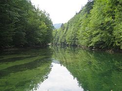 The Idrijca near the Wild Lake | |
| Location | |
| Country | Slovenia |
| Physical characteristics | |
| Mouth | |
• location | Soča |
• coordinates | 46°09′06″N 13°44′25″E / 46.1517°N 13.7404°E |
| Length | 60 km (37 mi) [1] |
| Basin size | 598 km2 (231 sq mi) [1] |
| Basin features | |
| Progression | Soča→ Adriatic Sea |


The river basin has an area of 598 square kilometres (231 sq mi).[1] The major tributaries are the Belca, Zala, Cerknica, and Bača from the right and the Nikomlja, Kanošica, and Trebušica from the left. One of the right tributaries is also the Jezernica River, which originates from the Wild Lake (Slovene: Divje jezero). Being only 55 m long, the Jezernica is the shortest river in Slovenia.
The river has many fish, among which the Salmo marmoratus, the rainbow trout, and the Grayling are noteworthy. In the past, timber was driven down the Idrijca to Idrija to be used as pillars in the Idrija mercury mine. Special logging sluices (Sln. klavže) were employed for this purpose from the 17th until the 19th century.
The area of the upper Idrijca has been proclaimed the Upper Idrijca Landscape Park. It encompasses numerous karst features and diverse plant species. During World War II, Pavla Partisan Hospital stood there.
Tributaries edit
- Senčni potok
- Nikova
- Kanomljica
- Otuška
- Sevnica
- Trebuščica
- Hotenja
- Črni potok
- Belca
- Zala
- Ljubevščica
- Zaspana grapa
- Skavnica
- Peklenska graba
- Grda grapa
- Luknjica
- Zaganjalčnica
- Cerknica
- Jesenica
- Bukovška grapa
- Žibernik
- Doberšček
- Bača
References edit
- ^ a b c d Rivers, longer than 25 km, and their catchment areas, Statistical Office of the Republic of Slovenia
- ^ Brečko Grubar, Valentina; Kovačič, Gregor (2010). "Pokrajinskoekološka oznaka jadranskega povodja v Sloveniji s poudarkom na kakovosti vodnih virov" [Landscape Ecological Characterization of the Adriatic Sea Basin in Slovenia with an Emphasis on Water Resource Quality]. Annales. Series historia et sociologia (in Slovenian). 20 (1): 153–168.
External links edit
 Media related to Idrijca at Wikimedia Commons
- Idrijca on Geopedia
- Condition of Idrijca - graphs, in the following order, of water level and flow for the past 30 days (taken in Podroteja by ARSO)