


Summary
Ightenhill is a civil parish in the Borough of Burnley in Lancashire, England, with a population of 1,975.[1]
| Ightenhill | |
|---|---|
 The site of Ightenhill Manor House | |
 Ightenhill Shown within Burnley Borough  Ightenhill Location within Lancashire | |
| Area | 1.71 sq mi (4.4 km2) [1] |
| Population | 1,975 (2011) [1] |
| • Density | 1,155/sq mi (446/km2) |
| OS grid reference | SD8208 |
| Civil parish |
|
| District | |
| Shire county | |
| Region | |
| Country | England |
| Sovereign state | United Kingdom |
| Post town | BURNLEY |
| Postcode district | BB12 |
| Dialling code | 01282 |
| Police | Lancashire |
| Fire | Lancashire |
| Ambulance | North West |
| UK Parliament | |

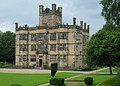
Since its creation as Ightenhill Park in 1866 the parish has seen a number of boundary changes. The modern civil parish includes Gawthorpe Hall and extends across the River Calder leaving the hill it is named after. As a result, adjoining parts of Burnley, although not inside the parish, are still locally considered part of the Ightenhill area. Much of the populated part of the parish is composed principally of large 1980s housing estates forming part of Burnley's urban area.
The parish adjoins the unparished area of Burnley and the parish of Padiham along with the Pendle parishes of Higham with West Close Booth, and Reedley Hallows. It is in the Whittlefield with Ightenhill ward of Burnley borough.
History edit
The name is historically recorded as Hightenhull (1238), Ightenhill (1242), Hucnhull (1258) and Ichtenhill (1296 and 1305).[2]
Ightenhill was one of the demesne manors of the Honour of Clitheroe, an estate administered from Clitheroe Castle.[3] The honour passed from the de Lacy family to the Earls, then Dukes of Lancaster, becoming part of the Duchy of Lancaster until 1661.[4] The manor covered a much larger area than the parish, including Heyhouses (now part of Sabden), Padiham, Habergham Eaves, Burnley, Briercliffe (without Extwistle) and Little Marsden (Nelson south of Walverden Water and Brierfield).[5] After 1661 the area of Pendle Forest was also included with it.[6] The site of Ightenhill Manor House (53°48′09″N 2°16′36″W / 53.8025°N 2.2766°W) is about a quarter of a mile to the east of Gawthorpe Hall on the brow of the hill, the site providing a good view of the whole of Pendle Forest.[7] Manorial courts were presumably originally held here before moving to Higham for Pendle Forest and Burnley for the rest of the manor.[8]
The earliest surviving reference of the name occurs in a charter signed here by John de Lacy, 2nd Earl of Lincoln in 1238, and it appears again in the grant of free warren obtained by his son Edmund in 1251.[8] Edmund also signed at least one charter here the same year.[9] The accounts of Henry de Lacy in 1296 show that a horse stud was already established here, in connection with three enclosures inside the forest, namely Higham and West Closes (in Higham with West Close Booth) and Filly Close in Reedley Hallows.[5] During the rebellion led by Thomas, 2nd Earl of Lancaster, raiders loyal to the king, took most of stock at Ightenhill and in the forests away to Skipton, as a result King Edward II stayed here for several days in October 1323.[8] The 19th-century historian T D Whitaker theorised that the site provided a preferred stop-over as the de Lacys travelled over the Pennines between Pontefract Castle and Clitheroe, and later as the Plantagenets continued on to Lancaster.[10] In 1327 the honour was among the lands granted to Queen Isabella, the mother of Edward III, however the park itself was retained by the king.[11] Continuing as a royal stud, records from 1343-44 show four horses were acquired by the first Duke of Cornwall, Edward the Black Prince.[12]
Parts of the park, at least, must have been enclosed under the de Lacys,[a] but in 1380, under John of Gaunt, the keeper of Pendle Chase was ordered to surround the entire park with a ditch and quickwood hedge.[14] The first Ordnance Survey map of the area, published in 1840s, shows the park to cover an area of 759 acres (307 ha) on the summit and northern side of the hill.[b][15]
From the early 1400s, the right to farm inside the park was leased to tenants.[17] The last park-keeper to be appointed was Robert Rishton in 1502,[18] and after 1507 the entire park was leased, with Rishton the first occupant, before passing it to the Towneleys by 1519. The manor house was a ruin by 1522, however a survey taken at the time gives detail on the buildings at the site, listing the hall with a great chamber and long chamber at its western end, also the kitchen, pantry, oven-house, great barn, chapel, stable and houses for the park-keeper and butler. In 1894 no part of the walls was still standing, but the foundations of the keep could still easily be traced. Stone from the site is thought have used in the construction of the neighbouring farmhouse.[17]
By 1593, the Shuttleworths of Gawthorpe had taken control of the park, probably a result of the recusancy of John Towneley. With the exception of the site of the manor house, the family later acquired the freehold title, and continued to own it into the 20th-century.[7]
Outside the park (and parish) a hamlet anciently known as Ightenhill lay to the south near to Whittlefield and Gannow.[2] Also, in the part of the parish across the Calder, Whittaker must have been a settlement comparable to Padiham during the Late Middle Ages, as that township was called Padiham cum Whitacre in 1296.[19] It was the residence of the Whittaker family from as early as 1311, until around the start of the 17th-century, when it also was acquired by the Shuttleworths.[20]
Quarrying stone for construction occurred at various sites including the area near the Tim Bobbin Public House and areas near Gawthorpe, into the 20th-century.[15][2]
Geography edit
The summit of Ighten Hill is approximately 146 metres above sea level. It is bounded to the north and east by the River Calder, and on the west by Green Brook and its tributary Sweet Clough. A ridge to the south has today been cut through by the M65 motorway and East Lancashire line railway, with the Leeds and Liverpool Canal running a in tunnel under it. As well as the civil parish, the hill extends under Burnley's Habergham, Whittlefield, with parts of Gannow and Lowerhouse districts, and part of the town of Padiham.[21]
In the early 19th-century the Calder had become extensively polluted by manufacturing waste and the Shuttleworths had its route diverted away from Gawthorpe to the other side of the valley.[22][15]
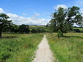
Gawthorpe is one of the trailheads of the Brontë Way, a 43-mile (69 km) long-distance footpath that crosses the South Pennines to Haworth, continuing to Oakwell Hall, Birstall, West Yorkshire. The Burnley Way also passes through the parish, with both crossing the bridge over the Calder on the bridleway to Higham.[23][24]
Governance edit
Ightenhill Park was an extra-parochial area surrounded by the ancient parish of Whalley. In 1866 the area became a civil parish.[25] The present parish was created in 1894, mainly from the former, but with the small part of Habergham Eaves lying north of A671 Padiham Road, added to it.[26] Before 1931 parts the south-west of the parish transferred into Burnley, aligning the boundaries of the parish with the County borough, however this change also brought the site of Gawthorpe Hall within the parish.[27] Since 1974 it has been part of the Borough of Burnley.
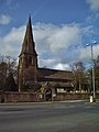
The neighbouring civil parish of North Town (historically associated with Padiham) was merged into Simonstone in 1983. However, after a public campaign to move that parish into the Borough of Ribble Valley and Boundary Commission review completed in 1985, the part of North Town south of the A6068 Padiham Bypass (across the River Calder) and areas between Gawthorpe Hall and Padiham were added to Ightenhill.[28] 2004 saw the parish regain some of the territory previously transferred to Burnley and added the area around All Saints Church and Park Hill School.[29]
Together with part of the unparished area of Burnley, the parish forms the Whittlefield with Ightenhill ward of Burnley Borough Council. [30][31] The ward elects three councillors, currently Lee Ashworth, Mike Steel, and Don Whitaker (all Conservative).[32] The parish is represented on Lancashire County Council as part of the Burnley Central West division, represented since 2021 by Andy Fewings (Green Party).[33]
The Member of Parliament for Burnley, the constituency into which the parish falls, is Antony Higginbotham (Conservative), who was first elected in 2019.
Demography edit
| Year | 1871 | 1881 | 1891 | 1901 | 1911 | 1921 | 1931 | 1951 | 1961 | 2001 | 2011 | ||||||||||
|---|---|---|---|---|---|---|---|---|---|---|---|---|---|---|---|---|---|---|---|---|---|
| Population | 149 | 205 | 519 | 113 | 132 | 152 | 159 | 158 | 157 | 1,512 | 1,975 | ||||||||||
| [1][25][26][34] | |||||||||||||||||||||
According to the United Kingdom Census 2011, the parish has a population of 1,975,[1] an increase from 1,512 in the 2001 census.[34] According to the 2001 Census the ward had 97.13% white ethnic group.[35] The index of multiple deprivation indicates that most of the ward is more affluent than the national average:[36] only 4.34% of children in the ward are eligible for free school meals.[37] There were 52.7 crimes per 1,000 inhabitants in the year to December 2007 (Lancashire average 89.4), a fall of 8.1% on the previous twelve months[37]
Media gallery edit
-
 Descending towards the River Calder on the Burnley Way
 -
 High Whittaker
 -
 Gawthorpe Hall
 -
 The Brontë Way also passes through the parish
 -
 Hagg Wood
 -
 All Saints with St John the Baptist Church


See also edit
References edit
Notes
- ^ Records from 1296 list fees paid for repairing the pales and diverting the Calder near Whitacre (Whittaker), to protect of the pales of the park[13]
- ^ In the 1840s the park was contained within the area between Padiham Road, Cornfield Grove, Clifton Road and the river.[15] Although only a small part of Clifton Road still exists, its destination Clifton Farm survives, more recently known as the Malt Shovel public house.[16]
Citations
- ^ a b c d e UK Census (2011). "Local Area Report – Ightenhill Parish (1170214986)". Nomis. Office for National Statistics. Retrieved 8 February 2018.
- ^ a b c Farrer & Brownbill 1911, p. 487
- ^ Whitaker 1872, p. 292
- ^ Farrer & Brownbill 1911, p. 361
- ^ a b Farrer & Brownbill 1911, p. 489, footnote
- ^ Whitaker 1872, pp. 343–4
- ^ a b Farrer & Brownbill 1911, p. 489
- ^ a b c Farrer & Brownbill 1911, p. 443
- ^ Whitaker 1876, p. 310
- ^ Whitaker 1876, p. 218
- ^ Whitaker 1872, p. 251
- ^ Whitaker 1872, pp. 308–312
- ^ Farrer & Brownbill 1911, p. 487, footnote
- ^ Farrer & Brownbill 1911, p. 488
- ^ a b c d Lancashire and Furness (Map) (1st ed.). 1 : 10,560. County Series. Ordnance Survey. 1848.
- ^ Historic England, "Former Clifton Farmhouse and Clifton Cottage (1244833)", National Heritage List for England, retrieved 13 March 2017
- ^ a b Farrer & Brownbill 1911, p. 488-9
- ^ Whitaker 1872, p. 313
- ^ Whitaker 1872, p. 86
- ^ Farrer & Brownbill 1911, pp. 493–4
- ^ 103 Blackburn & Burnley (Map). 1 : 50,000. Landranger. Ordnance Survey. 24 February 2016.
- ^ Farrer & Brownbill 1911, p. 464
- ^ MKH Computer Services Ltd. "Brontë Way — LDWA Long Distance Paths". ldwa.org.uk. Retrieved 21 March 2017.
- ^ MKH Computer Services Ltd. "Burnley Way — LDWA Long Distance Paths". ldwa.org.uk. Retrieved 21 March 2017.
- ^ a b "Ightenhill Park Tn/CP through time". visionofbritain.org.uk. GB Historical GIS / University of Portsmouth. Retrieved 1 August 2015.
- ^ a b "Ightenhill CP through time". visionofbritain.org.uk. GB Historical GIS / University of Portsmouth. Retrieved 1 August 2015.
- ^ Lancashire and Furness (Map). 1 : 2,500. County Series. Ordnance Survey. 1931. Retrieved 13 March 2017.
- ^ "Local Government Boundary Commission For England Report No. 5O5" (PDF). Local Government Boundary Commission For England. October 1985. Archived from the original (PDF) on 18 November 2015. Retrieved 13 March 2017.
- ^ "Burnley (Parishes) Order 2004" (PDF). Office of the Deputy Prime Minister. 27 January 2004. Archived from the original (PDF) on 16 January 2018. Retrieved 27 February 2021.
- ^ "Whittlefield with Ightenhill". MARIO. Lancashire County Council. Retrieved 26 March 2016.
- ^ "Whittlefield with Ightenhill". Ordnance Survey Linked Data Platform. Ordnance Survey. Retrieved 26 March 2016.
- ^ "Your Councillors". burnley.moderngov.co.uk. Burnley Borough Council. Retrieved 5 August 2023.
- ^ "County Councillors by Local Community". Lancashire County Council. Retrieved 5 August 2023.
- ^ a b UK Census (2001). "Local Area Report – Ightenhill Parish (30UD006)". Nomis. Office for National Statistics. Retrieved 8 February 2018.
- ^ Neighbourhood Statistics
- ^ Lancashire County Council Archived 2011-06-12 at the Wayback Machine Accessed 2010
- ^ a b Statistics – Lancashire MADE Public
Bibliography
- Farrer, William; Brownbill, John, eds. (1911), The Victoria History of the County of Lancaster Vol 6, Victoria County History, - Constable & Co, OCLC 832215477
- Whitaker, Thomas Dunham (1872), An history of the original Parish of Whalley, and honor of Clitheroe... 4th ed., vol. 1, George Routledge, OCLC 697798990
- Whitaker, Thomas Dunham (1876), An history of the original Parish of Whalley, and honor of Clitheroe... 4th ed., vol. 2, George Routledge, OCLC 697798990
External links edit
- Map of Ightenhill current (2011) parish boundary at Lancashire County Council website
- Map of Ightenhill parish boundary circa 1850
- Friends of Ightenhill Park
- Ightenhill Parish Council
- Ightenhill Primary School
- St Mary Magdalene's RC Primary School