


Summary
The Iloilo River is an estuary river located in the province of Iloilo, in Western Visayas, Philippines. The river starts in Oton at the Batiano estuary, then traverses through the Iloilo City districts of Lapuz, La Paz, Mandurriao, Molo, Arevalo and the City Proper, before emptying into the Iloilo Strait.
| Iloilo River | |
|---|---|
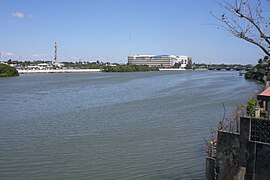
 View of the Iloilo River looking towards the Iloilo Provincial Capitol | |
 Iloilo River mouth  Iloilo River (Philippines) | |
| Native name | Subâ sang Iloilo (Hiligaynon) |
| Location | |
| Country | Philippines |
| Region | Western Visayas |
| Province | Iloilo |
| City/municipality | |
| Physical characteristics | |
| Source | Iloilo-Batiano River Basin |
| • location | Oton |
| Mouth | Iloilo Strait |
• location | Iloilo City |
• coordinates | 10°41′34″N 122°35′05″E / 10.69278°N 122.58472°E |
| Length | 26.4 km (16.4 mi)[1] |
| Basin size | 82.5 sq.kilometres (31.8 sq. miles) |
| Basin features | |
| Progression | Iloilo River – Iloilo Strait |
As an estuary, the river level fluctuates with the tides. This flow brings in nutrients from the sea, which makes the Iloilo River a nursery for fish species such as bangus and tilapia. The banks of the river are home to 22 of the country's 35 mangrove species, as well as the rare metapenaeus insolitus.[1]
Wharf edit

Iloilo River wharf, including Muelle Loney Street in the Iloilo City Proper, is a natural harbor which made it a preferred port of call for ships seeking protection from strong winds and tropical monsoons. It serves as port for inter island ferries that travel from Iloilo City to Bacolod on Negros and to Guimaras. It is also a drop-off point for fishing vessels that bring in their catch from the sea to be delivered to markets all over Iloilo.
Port edit
The Port of Iloilo was opened for international trade on 1855 and the coming of British Vice-consul Nicholas Loney, a year later, that led to the fast development of sugar industry in the region.
Esplanade edit
The Iloilo River Esplanade is a park development stretches on both sides of the river banks constructed as a recreation area and an attraction for visitors.[2]
Bridges edit
The bridges that cross the river include, into City Proper the Quirino-Lopez Bridge (built 1967, rehabilitated 2000) going to Lapuz district and Forbes (1910, rehabilitated 1975), Jalandoni and Drilon bridges going to La Paz district; and Diversion Bridge (1982) and Carpenters Bridge (2010, replacing a now-pedestrian only bridge) between Mandurriao and Molo districts.[3][4]
Gallery edit
-
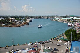
 Aerial view of the Iloilo River from Iloilo City Hall
 -
 Muelle Loney Wharf near downtown Iloilo
 -
 Iloilo River near La Paz district
 -
 Iloilo River at night
 -
 Ro-ro ferries in Lapuz district
 -
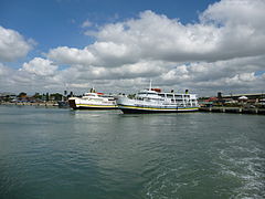
 Fast craft ferries from 2GO Travel and Oceanjet at the fast ferry terminal on the Iloilo River, going to Bacolod.


See also edit
References edit
- ^ a b "Iloilo River Protection". www.riversnetwork.org. Rivers Network. Retrieved 19 April 2017.
- ^ "Iloilo River Esplanade". Explore Iloilo. Retrieved 2023-07-30.
- ^ Pendon, Lydia C. (2012). "Drilon wants name at bridge erased". The Daily Guardian. Archived from the original on 4 March 2016. Retrieved 12 May 2014.
- ^ Pendon, Lydia C. (June 10, 2013). "DOT launches 7 Bridges of Blessings in Iloilo City". Sun-Star Iloilo. Retrieved 12 May 2014.