


Summary
Ingleside is a neighborhood in Holyoke, Massachusetts located to the south of the city center, approximately 2 miles (3.2 km) from downtown. The neighborhood features access to the Connecticut River through the Sue Ellen Panitch River Center and the Land of Providence reservation. Ingleside is also home to the Holyoke Mall, the Nuestras Raices farm, the Sisters of Providence of Holyoke, the Providence Behavioral Health Hospital, and several recreational and historical venues.
Ingleside | |
|---|---|
 McCleary Manor on Brightside Hill, Ingleside | |
 Ingleside  Ingleside  Ingleside | |
| Coordinates: 42°10′30.33″N 72°37′58.32″W / 42.1750917°N 72.6328667°W | |
| Country | United States |
| State | Massachusetts |
| City | Holyoke |
| Wards | 2, 5 |
| precincts | 2A, 5A |
| Area | |
| • Total | 0.69 sq mi (1.8 km2) |
| Elevation | 161 ft (49 m) |
| ZIP code | 01040 |
| Area code | 413 |
| GNIS feature ID | 608757[2] |
While Ingleside holds the same ZIP code as the rest of Holyoke, it is served by its own post office, maintained at the Holyoke Mall.[3]
History edit


Prior to the annexation of Holyoke from West Springfield in 1850, Ingleside was the site of a ferry known as the Jones' ferry,[4] its landing sites are known as Jones Ferry Road on both the Holyoke and Chicopee sides of the Connecticut River today.[5]
The word ingle, stemming from a Gaelic word for fire,[6] may have been chosen for lime kilns which were once in the vicinity in its time as a part of West Springfield.[7] The origin of the name Ingleside itself seems to stem from the eponymous Ingleside Hotel, a large complex constructed by one Jones S. Davis, a key figure in the creation of the city's Lyman Mills, which are now known as Open Square.[8][9]
Completed in 1868, the hotel cost Mr. Davis a total of $162,000 (approximated $3.6 million in 2016 US Dollars), and opened on July 4. On July 21, 1871, the hotel hosted the first college rowing regatta in the United States held by the Rowing Association of American Colleges, one of the country's earliest intercollegiate undergraduate sporting events. Held on the banks of the Connecticut River, Massachusetts Agricultural College won the event in an upset against the teams of Harvard, Yale, and Brown.[10] This would be one of the only significant events in the resorts history however, as following the Panic of 1873, it would be sold at auction to one N.S. Chandler "for a little less than $30,000".[8] The hotel, which featured a farm, telegram station, gasworks, and railway stop, was short-lived however, and closed in the winter of 1874 due to low attendance in the midst of an economic depression.[11] The hotel was razed by fire on July 25, 1875, with some indication that the blaze "was the work of an incendiary".[12][13] The hotel and its contents were insured in total for $20,000.[14] Though the hotel itself stood on the shores of the Connecticut for less than a decade, the Ingleside name would persist as that of the surrounding area long after its absence.[15]
Geography edit

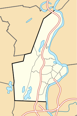
The contemporary boundaries of Ingleside are defined by Rt 91 to its west, railroad tracks to its north west, Springdale park to its northeast, the Connecticut River to its east, and West Springfield to its south.[1]
Geology edit
Ingleside's western boundaries contain primarily sand and gravel deposits created by aeolian processes, creating an abundance of gravelly silty loam. In contrast the easterly portion of the neighborhood, which is adjacent to the Connecticut River, consists of floodplain alluvium.[16] The boundary of Ingleside which borders the river contains FEMA regulated floodways which are part of a 100-year floodplain, defined by the agency as areas with a 1% chance of flooding per annum.[17][18]
Transportation edit


Streets and highways edit
Ingleside is directly accessible from U.S. Interstate 91 via Exit 15, Lower Westfield Rd./Ingleside. U.S. Route 5 traverses the neighborhood from north to south, with direct access to I-91 via exit 14, and the Massachusetts Turnpike I-90 via exit 4 at Holyoke's border with West Springfield. To its north Route 5 splits from Main Street, which continues northeasterly toward Springdale.
Several bus routes serve Ingleside, including PVTA R29 at Providence Hospital, P20 at the Holyoke Crossing shopping center, and these routes, along with the P20 Express and R41, serve the Holyoke Mall. Peter Pan Buslines also serves the Holyoke Mall stop with connections to points north and Springfield Union Station.[19]
Rail edit
Ingleside was originally a stop on the New York, New Haven and Hartford Railroad but is no longer serviced by passenger rail service.[20] A freight railway defines the northwest of the neighborhood and is presently a rail connection for the Pioneer Valley Railroad, which services rails between Westfield, Southampton, and the factory-access railways in Holyoke's canal district.
Boat edit
Public boat access on the Connecticut River is available for small craft from the Sue Ellen Panitch River Center on Jones Ferry Road.[21] While portage is required for all points north of the Hadley Falls Dam or south of the dam in Enfield, Connecticut, the river can be navigated largely uninterrupted between these two points.[22]
References edit
- ^ a b Spatial analysis of "Holyoke Neighborhoods" (PDF). Archived from the original (PDF) on 2 August 2017. Retrieved 3 Jun 2016.
- ^ a b "Ingleside, Holyoke, Massachusetts". Geographic Names Information System. United States Geological Survey, United States Department of the Interior. Retrieved 12 Nov 2017.
- ^ Ingleside Mall, Location Details. United States Postal Service.
- ^ "New Advertisements". Springfield Republican. March 4, 1863. p. 2.
For Sale— The Ferry known as the Chicopee or Jones Ferry, with house and seven acres of land. For particulars inquire of P. Ely, Holyoke
- ^ Google (28 December 2017). "Jones Ferry Rd and The Connecticut River" (Map). Google Maps. Google. Retrieved 28 December 2017.
- ^ "ingle". Merriam-Webster.com Dictionary. Retrieved 2017-12-29.
- ^ Ella M. DiCarlo (July 1, 1978). "Ingleside: Where Once the Indians Roamed the Land". Holyoke Transcript-Telegram.
- ^ a b Burt, Henry M. (1874). "Ingleside". Burt's guide through the Connecticut Valley to the White mountains and the river Saguenay. Springfield, Mass.: New England Publishing Company. pp. 72–73. OCLC 2579496.
- ^ "Movie of the Week:Magdalena's Brain". MTV. November 2, 2007. Archived from the original on 29 December 2017.
The film's primary location was Holyoke's Open Square, formerly known as the Lyman Mills. Open Square is a 600,000 sq. ft. building which owner/architect John P. Aubin has been redeveloping since 1996.
- ^ Sippel, John (Summer 2018). "Muscle, Pluck, & Yankee Vim". UMass Magazine. Archived from the original on May 3, 2019.
- ^ "The Burning of 'Ingleside'". Providence Evening Press. Providence, RI. July 26, 1875. p. 3.
- ^ "By Telegraph". The Evening Post. New York. July 26, 1875. p. 4.
The fire at Ingleside, the summer resort near Springfield, Mass. proves to have been the work of an incendiary.
- ^ Holyoke, Past and Present, 1745-1895. The Transcript Publishing Co. 1895. p. 68. OCLC 11107520.
- ^ "Ingleside Burned. Complete Destruction of a Well Known Summer Resort—The Loss and Insurance". Springfield Republican. Springfield, Mass. July 26, 1875. p. 5.
Springfield, Mass., July 25, 1875. Ingleside, a well known summer resort, about three miles southwest of Holyoke was destroyed by fire this evening. It was built by J. S. Davis of Holyoke, a few years ago, at a cost of $150,000, but was sold in 1874 to N. S. Chandler, of this city, for $30,000, and has not been open for guests this season. Engines were sent over from Holyoke, but were useless as there was no water except in a small reservoir and none could be pumped up from the Connecticut. Eighty tons of hay were burned in the barn and only a small portion of the furniture saved, and that in a damaged condition. The insurance is $20,000.
- ^ "Ingleside, Hampden County, Massachusetts". Geographic Names Information System. United States Geological Survey, United States Department of the Interior.
- ^ MassGIS Data - Surficial Geology (1:250,000), MassGIS, Executive Office for Administration and Finance
- ^ MassGIS Data - FEMA National Flood Hazard Layer, MassGIS, Executive Office for Administration and Finance
- ^ Definitions of FEMA Flood Zone Designations, Map Service, Federal Emergency Management Agency
- ^ Pioneer Valley Transit Authority, Routes and Schedules
- ^ "The New York, New Haven and Hartford Railroad : operated and controlled lines" (Map). The New York, New Haven and Hartford Railroad : operated and controlled lines. Buffalo: The Matthews-Northrup Works. 1905.
- ^ Connecticut River Greenway State Park, HG&E and MassDCR
- ^ Recreational Guide to the Connecticut River:Holyoke MA to Enfield CT. Inland Guides. Vol. 8004. Connecticut River Conservancy. 2008.
Further reading edit
- Sippel, John (Summer 2018). "Muscle, Pluck, & Yankee Vim". UMass Magazine. Archived from the original on May 3, 2019.
External links edit
- Ingleside Mall Post Office, location hours and services
- Holyoke Rows, a non-profit organization which operates the Panitch River Center
- Map of the Land of Providence, maintained by The Trustees of the Reservations
- Nuestras Raices, urban agricultural center with fields and facilities in Ingleside