
KNOWPIA
WELCOME TO KNOWPIA

Iranian Plate 
Summary
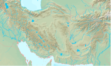
The Iranian Plate is a small tectonic plate thought to underlie the Persian plateau, covering the modern-day countries of Iran and Afghanistan, and parts of Iraq and Pakistan. It is compressed between the Arabian Plate to the southwest, the Eurasian Plate to the north, and the Indian Plate to the southeast. This compression is likely a cause for the very mountainous terrain of the area including the Alborz and Zagros Mountains.
References edit
- William Bayne Fisher: The Middle East: a Physical, Social, and Regional Geography. Routledge 1978, ISBN 978-0-416-71520-0, p. 15–16