


Summary
Irulam
Irulam | |
|---|---|
village | |
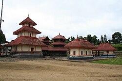 Seetha Lava Kusha Temple, Irulam | |
| Coordinates: 11°45′0″N 76°11′0″E / 11.75000°N 76.18333°E | |
| Country | |
| State | Kerala |
| District | Wayanad |
| Population (2001) | |
| • Total | 21,111 |
| Languages | |
| • Official | Malayalam |
| Time zone | UTC+05:30 (IST) |
| PIN | 673579 |
| ISO 3166 code | IN-KL |
| Vehicle registration | KL-73 |
| Nearest city | Pulpally |
| Literacy | 95% |
| Lok Sabha constituency | Wayanad |
| Vidhan Sabha constituency | Sultan Bathery |
| Irulam | |
|---|---|
| village | |
| Seetha Lava Kusha Temple, Irulam | |
| Coordinates: 11°45′0″N 76°11′0″E | |
| Country | India |
| State | Kerala |
| District | Wayanad |
| Population
(2001) | |
| • Total | 21,111 |
| Languages | |
| • Official | Malayalam |
| Time zone | UTC+05:30 (IST) |
| PIN | 673579 |
| ISO 3166 code | IN-KL |
| Vehicle registration | KL-73 |
| Nearest city | Pulpally |
| Literacy | 95% |
| Lok Sabha constituency | Wayanad |
| Vidhan Sabha constituency | Sultan Bathery |
Demographics edit
As of 2001[update] India census, Irulam had a population of 21111 with 10637 males and 10474 females.[1]
Economy edit
The main crops in the village are pepper, coffee, cardamom, paddy and ginger.
Transportation edit
Irulam village can be accessed from Sultan Bathery or Pulpally. The Periya ghat road connects Mananthavady to Kannur and Thalassery. The Thamarassery mountain road connects Calicut with Kalpetta. The Kuttiady mountain road connects Vatakara with Kalpetta and Mananthavady. The Palchuram mountain road connects Kannur and Iritty with Mananthavady. The road from Nilambur to Ooty is also connected to Wayanad through the village of Meppadi.
The nearest railway station is at Mysore and the nearest airports are Kozhikode International Airport-120 km, Bengaluru International Airport-290 km, and Kannur International Airport, 58 km.
Image Gallery edit
-
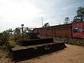
 Irulam junction
 -
 Temple Wall
 -
 Mandapam
 -
 Sacred Tree


References edit
- ^ "Census of India : Villages with population 5000 & above". Registrar General & Census Commissioner, India. Archived from the original on 11 February 2008. Retrieved 10 December 2008.