
KNOWPIA
WELCOME TO KNOWPIA

Irupana Municipality 
Summary
Irupana Municipality or Villa de Lanza Municipality is the second municipal section of the Sud Yungas Province in the La Paz Department, Bolivia. Its seat is Irupana.
Irupana | |
|---|---|
Municipality | |
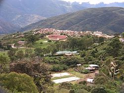 Irupana | |
 Irupana Location within Bolivia | |
| Coordinates: 16°30′S 67°30′W / 16.500°S 67.500°W | |
| Country | |
| Department | La Paz Department |
| Province | Sud Yungas Province |
| Seat | Irupana |
| Government | |
| • Mayor | Clemente Mamani Condorena (2007) |
| Elevation | 5,900 ft (1,800 m) |
| Population (2001) | |
| • Total | 11,383 |
| Time zone | UTC-4 (BOT) |

Geography edit
The Cordillera Real traverses the municipality. The highest peaks of the municipality is Illimani at 6,438 m (21,122 ft) above sea level. Other mountains are listed below:[1][2][3]
- Allpaqani
- Churu
- Ch'iyar Qullu
- Ch'uxña Pata
- K'illimani
- K'uchu Munti
- K'usill Willk'i
- Layqa Qullu
- Llaytuwani
- Link'u Link'u
- Mururata
- Pararani
- Pupusani
- Qaqinkura
- Qutapata
- Thiya Quta
- Waychuni
- Wisk'achani
Subdivision edit
Irupana Municipality is divided into six cantons.
| Canton | Inhabitants (2001)[4] | Seat | Inhabitants (2001) |
|---|---|---|---|
| Irupana | 4,465 | Irupana | 1,882 |
| Lambate | 2,693 | Lambate | 347 |
| Laza | 800 | Laza | 164 |
| Taca | 1,080 | Taca | 183 |
| Chicaloma | 1,177 | Chicaloma | 634 |
| Victorio Lanza | 1,168 | Victorio Lanza | 181 |
See also edit
References edit
- ^ Bolivian IGM map 1:50,000 Araca 6043-I
- ^ Bolivian IGM map 1:50,000 Lambate 6044-II
- ^ "Irupana". INE, Bolivia. Archived from the original on March 26, 2016. Retrieved March 18, 2016.
- ^ www.ine.gob.bo Archived 2011-09-24 at the Wayback Machine
External links edit
- Irupana Municipality: Population data and map
16°30′S 67°30′W / 16.5°S 67.5°W