


Summary
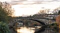
Island Bridge (Irish: Droichead na hInse),[3] formerly Sarah or Sarah's Bridge, is a road bridge spanning the River Liffey, in Dublin, Ireland which joins the South Circular Road to Conyngham Road at the Phoenix Park.[4]
Islandbridge Droichead na hInse | |
|---|---|
 Island Bridge circa 1820 (then called "Sarah's Bridge") | |
| Coordinates | 53°20′50″N 6°18′30″W / 53.3472°N 6.3083°W |
| Crosses | River Liffey |
| Locale | Dublin, Ireland |
| Preceded by | First: 1577 Rebuilt: 1791 Renamed: 1922 |
| Characteristics | |
| Design | Arch bridge |
| Material | Ashlar masonry |
| Total length | 32m[1] |
| No. of spans | 1 |
| History | |
| Designer | Alexander Stevens[2] |
| Construction end | 1791-1793 |
| Location | |
 | |
Island Bridge and the surrounding area (often known as Islandbridge)[5] are so named because of the island formed here by the creation of a mill race towards the right bank while the main current flows to the left. The River Camac emerges from a tunnel further downstream towards Dublin Heuston railway station.
History edit
The area around Islandbridge contains a number of notable Viking burial sites from the 9th and 10th century which indicate the area as being one of the earliest recorded contacts between the vikings and Ireland.[6][7] It was also a fording point, on the River Liffey, since at least the early medieval period.[8]
In 1577, during the reign of Queen Elizabeth, while Sir Henry Sidney was Lord Deputy of Ireland, an arched stone bridge was built here to replace an earlier structure nearby at Kilmainham.[9]
This bridge was swept away by a flood in 1787,[9] and between 1791 and 1793 the replacement bridge, that is standing today, was constructed. The structure is a single 32-metre span ashlar masonry elliptical arch bridge[10] and was originally named Sarah's Bridge after Sarah Fane, Countess of Westmorland, wife of the then Lord Lieutenant of Ireland, who laid the first stone on 22 June 1791.[11]
The bridge was renamed Island Bridge in 1922 following independence from Britain of the Free State, similarly to many other Dublin bridges originally named for British peers.
The bridge has become synonymous with the area, and the residential area around the bridge is now commonly known as "Islandbridge".[5]
See also edit
- Clancy Quay, formerly the site of Islandbridge Barracks
Gallery edit
-
 Islandbridge taken from Clancy Quay, in 2020.
 -
 Road view of the bridge
 -
 Islandbridge in 2012
 -


References edit
- ^ Island Bridge at Structurae
- ^ Ruddock, Ted (2008). Arch Bridges and Their Builders 1735-1835. Cambridge University Press. p. 122. ISBN 978-0-521-09021-6.
- ^ "Droichead na hInse". logainm.ie. Placenames Database of Ireland. Retrieved 19 October 2022.
- ^ "Island Bridge, South Circular Road, Islandbridge, Dublin 8, DUBLIN". Buildings of Ireland. Retrieved 18 October 2022.
- ^ a b "Dublin 8: Move over Phibsboro – another Dublin neighbourhood hits the ultimate 'cool' list". independent. Retrieved 18 October 2022.
- ^ "Viking Archaeology - Viking Age Burials in Dublin". viking.archeurope.info. Retrieved 20 December 2023.
- ^ "The Vikings beneath modern Dublin". The Irish Times. Retrieved 20 December 2023.
- ^ Underwater Archaeological Impact Assessment (UAIA) Proposed Rowing Pontoon, River Liffey, Islandbridge, Co. Dublin (PDF) (Report). Dublin City Council. June 2023. p. 5. Retrieved 20 December 2023.
- ^ a b De Courcy, John W. (1996). The Liffey in Dublin. Gill & Macmillan. ISBN 0-7171-2423-1.
- ^ Current and Future Trends in Bridge Design, Construction and Maintenance. Institution of Civil Engineers. 2001. ISBN 0-7277-3091-6.
- ^ "Bridges". Chapters of Dublin History. Archived from the original on 31 October 2007.