


Summary
Itterswiller (German: Ittersweiler) is a commune in the Bas-Rhin department in Alsace in north-eastern France.[3]
Itterswiller
Itterschwiller | |
|---|---|
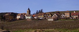 A general view of Itterswiller | |
 Coat of arms | |
Location of Itterswiller .mw-parser-output .locmap .od{position:absolute}.mw-parser-output .locmap .id{position:absolute;line-height:0}.mw-parser-output .locmap .l0{font-size:0;position:absolute}.mw-parser-output .locmap .pv{line-height:110%;position:absolute;text-align:center}.mw-parser-output .locmap .pl{line-height:110%;position:absolute;top:-0.75em;text-align:right}.mw-parser-output .locmap .pr{line-height:110%;position:absolute;top:-0.75em;text-align:left}.mw-parser-output .locmap .pv>div{display:inline;padding:1px}.mw-parser-output .locmap .pl>div{display:inline;padding:1px;float:right}.mw-parser-output .locmap .pr>div{display:inline;padding:1px;float:left}html.skin-theme-clientpref-night .mw-parser-output .od,html.skin-theme-clientpref-night .mw-parser-output .od .pv>div,html.skin-theme-clientpref-night .mw-parser-output .od .pl>div,html.skin-theme-clientpref-night .mw-parser-output .od .pr>div{background:#000;color:#fff}html.skin-theme-clientpref-night .mw-parser-output .locmap{filter:grayscale(0.6)}@media(prefers-color-scheme:dark){html.skin-theme-clientpref-os .mw-parser-output .locmap{filter:grayscale(0.6)}html.skin-theme-clientpref-os .mw-parser-output .od,html.skin-theme-clientpref-os .mw-parser-output .od .pv>div,html.skin-theme-clientpref-os .mw-parser-output .od .pl>div,html.skin-theme-clientpref-os .mw-parser-output .od .pr>div{background:#000;color:#fff}}  Itterswiller  Itterswiller | |
| Coordinates: 48°21′53″N 7°25′54″E / 48.3647°N 7.4317°E | |
| Country | France |
| Region | Grand Est |
| Department | Bas-Rhin |
| Arrondissement | Sélestat-Erstein |
| Canton | Obernai |
| Government | |
| • Mayor (2020–2026) | Vincent Kieffer[1] |
| Area 1 | 11.8 km2 (4.6 sq mi) |
| Population (2021)[2] | 224 |
| • Density | 19/km2 (49/sq mi) |
| Time zone | UTC+01:00 (CET) |
| • Summer (DST) | UTC+02:00 (CEST) |
| INSEE/Postal code | 67227 /67140 |
| Elevation | 220–287 m (722–942 ft) |
| 1 French Land Register data, which excludes lakes, ponds, glaciers > 1 km2 (0.386 sq mi or 247 acres) and river estuaries. | |
Geography edit
The village is located on the eastern beginnings of the Vosges Mountains, between Molsheim to the north and Sélestat top the south. It is a few kilometres to the west of the Autoroute A35, the principal north-south highway in Alsace.
Economy edit
Tourism is important to the local economy which is positioned on the Elsässer Weinstraße. The village also takes a pride in its vineyards.
History edit
The village is on the course of a Roman road: it is therefore believed that the area must have been settled during the Roman empire period. The name is thought to come from the Latin "Itineris villa" which indicates a hostelry for travellers.
In terms of surviving written records, a so-called Letter of Indulgence to Itterswiller dates from 1330.
Celebrations edit
An annual church festival takes place at the end of September or start of October.
See also edit
References edit
- ^ "Répertoire national des élus: les maires". data.gouv.fr, Plateforme ouverte des données publiques françaises (in French). 2 December 2020.
- ^ "Populations légales 2021". The National Institute of Statistics and Economic Studies. 28 December 2023.
- ^ INSEE commune file