


Summary
Izumizaki (泉崎村, Izumizaki-mura) is a village located in Fukushima Prefecture, Japan. As of 1 March 2020[update], the village had an estimated population of 6,265 in 2179 households,[1] and a population density of 180 persons per km². The total area of the village was 35.43 square kilometres (13.68 sq mi).
Izumizaki
泉崎村 | |
|---|---|
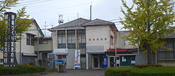 Izumizaki Town Hall | |
 Flag  Seal | |
 Location of Izumizaki in Fukushima Prefecture | |
 Izumizaki | |
| Coordinates: 37°9′25″N 140°17′43.3″E / 37.15694°N 140.295361°E | |
| Country | Japan |
| Region | Tōhoku |
| Prefecture | Fukushima |
| District | Nishishirakawa |
| Area | |
| • Total | 35.43 km2 (13.68 sq mi) |
| Population (March 2020) | |
| • Total | 6,265 |
| • Density | 180/km2 (460/sq mi) |
| Time zone | UTC+9 (Japan Standard Time) |
| - Tree | Ginkgo biloba |
| - Flower | Rhododendron indicum |
| Phone number | 0248-53-2111 |
| Address | Hachimaru 145, Izumizaki-mura, Nishishirakawa-gun, Fukushima-ken 969-0101 |
| Website | Official website |

Geography edit
Izumizaki is located in the flatlands of south-central Fukushima prefecture.
Neighboring municipalities edit
Demographics edit
Per Japanese census data,[2] the population of Izumizaki has remained relatively stable over the past 80 years.
| Year | Pop. | ±% |
|---|---|---|
| 1920 | 4,157 | — |
| 1930 | 4,699 | +13.0% |
| 1940 | 5,130 | +9.2% |
| 1950 | 6,957 | +35.6% |
| 1960 | 6,541 | −6.0% |
| 1970 | 5,490 | −16.1% |
| 1980 | 5,577 | +1.6% |
| 1990 | 6,656 | +19.3% |
| 2000 | 6,823 | +2.5% |
| 2010 | 6,802 | −0.3% |
Climate edit
Izumizaki has a humid climate (Köppen climate classification Cfa). The average annual temperature in Izumizaki is 11.6 °C (52.9 °F). The average annual rainfall is 1,333 mm (52.5 in) with September as the wettest month.[3]
- Rivers: Abukuma River, Izumi River
History edit
The area of present-day Izumizaki was part of ancient Mutsu Province and the area has many burial mounds from the Kofun period. The area was divided between part of the holdings of Shirakawa Domain, Kasama Domain and tenryō territory held directly by the Tokugawa shogunate during the Edo period. After the Meiji Restoration, it was organized as part of Nishishirakawa District in the Nakadōri region of Iwaki Province. The villages of Izumizaki and Sekihira were established with the creation of the modern municipalities system on April 1, 1889. The two villages merged in 1954.
Economy edit
The economy of Izumizaki is primarily agricultural.
Education edit
Izumizaki has two public elementary schools and one public junior high school operated by the village government. The village does not have a high school.
- Izumizaki Middle School
- Izumizaki First Elementary School
- Izumizaki Second Elementary School
Transportation edit
Railway edit
Highway edit
Local attractions edit
- Izumizaki Cave Tomb (National Historic Site)[4]
- Shirakawa Kanga ruins (National Historic Site)[5]
- Izumisaki International Cycling Stadium
Noted people from Izumizaki edit
- Tamanoshima Arata, sumo wrestler
References edit
External links edit
 Media related to Izumizaki, Fukushima at Wikimedia Commons
- Official website (in Japanese)