


Summary
Jahrom County (Persian: شهرستان جهرم) is in Fars province, Iran. Its capital is the city of Jahrom.[3]
Jahrom County
Persian: شهرستان جهرم | |
|---|---|
County | |
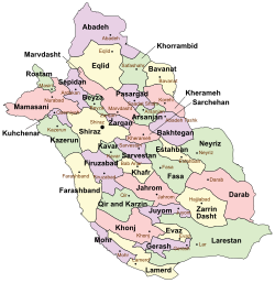 Location of Jahrom County in Fars province (center, pink) | |
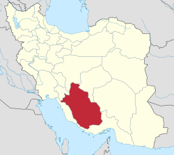 Location of Fars province in Iran | |
| Coordinates: 28°38′N 53°22′E / 28.633°N 53.367°E[1] | |
| Country | |
| Province | Fars |
| Capital | Jahrom |
| Districts | Central, Kordian, Simakan |
| Population (2016)[2] | |
| • Total | 228,532 |
| Time zone | UTC+3:30 (IRST) |
| Jahrom County can be found at GEOnet Names Server, at this link, by opening the Advanced Search box, entering "9206470" in the "Unique Feature Id" form, and clicking on "Search Database". | |
At the 2006 census, the county's population was 197,331 in 48,335 households.[4] The following census in 2011 counted 209,312 people in 58,940 households.[5] At the 2016 census, the county's population was 228,532 in 70,187 households.[2]
Administrative divisions edit
The population history and structural changes of Jahrom County's administrative divisions over three consecutive censuses are shown in the following table. The latest census shows four districts, 12 rural districts, and five cities.[2]
In 2019, Khafr District was separated from the county in the establishment of Khafr County.[6]
| Administrative Divisions | 2006[4] | 2011[5] | 2016[2] |
|---|---|---|---|
| Central District | 124,134 | 137,055 | 152,953 |
| Jolgah RD | 18,977 | 21,030 | 9,257 |
| Kuhak RD | 2,134 | 1,917 | 2,062 |
| Jahrom (city) | 103,023 | 114,108 | 141,634 |
| Khafr District[a] | 42,199 | 40,535 | 42,263 |
| Aliabad RD | 7,138 | 6,454 | 5,860 |
| Gel Berenji RD | 7,281 | 8,080 | 8,650 |
| Khafr RD | 8,359 | 3,057 | 3,396 |
| Rahgan RD | 8,368 | 8,269 | 9,071 |
| Sefidar RD | 4,214 | 3,632 | 3,893 |
| Bab Anar (city) | 1,702 | 6,968 | 7,061 |
| Khavaran (city) | 5,137 | 4,075 | 4,332 |
| Kordian District | 14,025 | 13,691 | 14,851 |
| Alaviyeh RD | 6,006 | 5,542 | 5,813 |
| Qotbabad RD | 1,569 | 1,395 | 1,562 |
| Qotbabad (city) | 6,450 | 6,754 | 7,476 |
| Simakan District | 16,973 | 16,655 | 17,560 |
| Pol Beh Bala RD | 6,718 | 5,908 | 6,033 |
| Pol Beh Pain RD | 5,028 | 5,069 | 5,044 |
| Posht Par RD | 5,227 | 4,791 | 5,135 |
| Duzeh (city) | 887 | 1,348 | |
| Total | 197,331 | 209,312 | 228,532 |
| RD = Rural District | |||
Geography edit
Jahrom County is located in the south of Fars province and has an area of 3,926 square kilometers. The county is bounded from the north by Khafr County, from the east by Fasa County and Zarrin Dasht County, from the south by Juyom County, from the west by Firuzabad County and Qir and Karzin County. The average altitude of this county is about 50 meters, and its highest point, Sefidar Peak, between Khafr county and Simakan District, is about 317 meters, and its lowest point is about 85 meters above sea level in Simian District. Qarah-Aghaj, and the Shur and Simakan rivers are among the waterways of Jahrom.[7] [citation needed]
Notes edit
- ^ Became a part of Khafr County after the 2016 census[6]
References edit
- ^ OpenStreetMap contributors (19 September 2023). "Jahrom County" (Map). OpenStreetMap. Retrieved 19 September 2023.
- ^ a b c d "Census of the Islamic Republic of Iran, 1395 (2016)". AMAR (in Persian). The Statistical Center of Iran. p. 07. Archived from the original (Excel) on 6 April 2022. Retrieved 19 December 2022.
- ^ Habibi, Hassan (21 June 1369). "Approval of the organization and chain of citizenship of the elements and units of the national divisions of Fars province, centered in Shiraz". Lamtakam (in Persian). Ministry of Interior, Council of Ministers. Archived from the original on 7 December 2023. Retrieved 7 December 2023.
- ^ a b "Census of the Islamic Republic of Iran, 1385 (2006)". AMAR (in Persian). The Statistical Center of Iran. p. 07. Archived from the original (Excel) on 20 September 2011. Retrieved 25 September 2022.
- ^ a b "Census of the Islamic Republic of Iran, 1390 (2011)". Syracuse University (in Persian). The Statistical Center of Iran. p. 07. Archived from the original (Excel) on 16 January 2023. Retrieved 19 December 2022.
- ^ a b Jahangiri, Ishaq. "Letter of approval regarding country divisions of Jahrom County, Fars province". Qavanin (in Persian). Ministry of Interior, Council of Ministers. Archived from the original on 22 September 2023. Retrieved 22 September 2023.
- ^ توریستی, چهارگوشه-معرفی استان ها و شهر های ایران و جاذبه های. "شهر زیبای جهرم". چهارگوشه - معرفی استان ها و شهر های ایران و جاذبه های توریستی (in Persian). Retrieved 28 December 2022.