


Summary
La grande isle de Java ("the great island of Java") was, according to Marco Polo, the largest island in the world; his Java Minor was the actual island of Sumatra, which takes its name from the city of Samudera (now Lhokseumawe) situated on its northern coast.[1]
Earliest account edit
Due to a scribal error in Book III of Marco Polo's travels treating of the route southward from Champa, where the name Java was substituted for Champa as the point of departure, Java Minor was located 1,300 miles to the south of Java Major, instead of from Champa, on or near an extension of the Terra Australis.[2]
As explained by Sir Henry Yule, the editor of an English edition of Marco Polo's travels: "Some geographers of the 16th century, following the old editions which carried the travellers south-east of Java to the land of Boeach (or Locac), introduced in their maps a continent in that situation".[3]
Jean Alfonse's cosmography edit

Java Minor was identified as an island (the present Island of Java) by the Franco-Portuguese navigator and cosmographer Jean Alfonse in his work of 1544, La Cosmographie but Java Major according to him was part of the continent of Terra Australis, which extended as far as the Antarctic Pole and the Strait of Magellan. In La Cosmographie, Alfonse defined La Grande Jave as an extension of the giant Antarctic continent, or Terra Australis: "This Java touches the Strait of Magellan in the west, and in the east Terra Australis ... I estimate that the coast of the Ocean Sea called the Austral coast extends eastwards to Java, to the western coast of the said Java."[4] Apparently in deference to Marco Polo's claim that Java Major was the largest island in the world, Alfonse gave the name Jave Mynore to the island of Java and the name La Grand Jave to the continental land to the south. Marco Polo's Java Minor, he called Samatrez (Sumatra). In La Cosmographie (1544), Alfonse said:
La Grand Jave is a land that goes as far as under the Antarctic Pole and from the Terre Australle in the west to the land of the Strait of Magellan on the eastern side. Some say that it is islands but from what I have seen of it, it is terre ferme [a continent] ... That called Jave Mynore is an island, but la Grand Jave is terre ferme.[5]
Later cartography edit
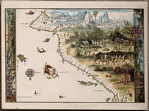
This cosmographical concept was exhibited in the mid-sixteenth century mappemondes of the School of mapmakers centred at Dieppe, Normandy, which in later times gave rise to the idea that Australia may have been discovered by Europeans long before the Dutch began to chart its coast in 1606 or before James Cook charted its east coast in 1770. This is seen clearly in Jean Rotz's Lande of Java of 1542, the Dauphin Map or Harleian World Map of c. 1547,[6] and in Pierre Desceliers' mappemonde of 1546.[7] Alfonse's map of La Grande Jave bears a striking resemblance to that of Rotz.
Vincenzo Coronelli, on his Terrestrial Globe made in Venice in 1688, referred to the uncertainty regarding the location of Marco Polo's Java Minor, noting that while in the opinion of some it could be identified with Sumatra, others believed it to be Sumbawa or New Holland. His inscription reads: "Various are the opinions of the Geographers concerning the location of Giava minore, some placing it under the Tropic of Capricorn, in accordance with what Marco Polo wrote in bk.3, cap.13. Others believe it to be Sumatra from the distance which the same Polo assigned to it, others take it for the Island of Sumbawa, and some others, more modern, for New Holland. We, from so much variety of opinion, do not offer a final conclusion on the matter, leaving the dispute undecided."[8]

In accordance with the uncorrected editions of Marco Polo's travels, on his 1688 Terrestrial Globe Coronelli inscribed over the northern part of Nuova Hollandia: "Some believe that in this place M. Polo discovered the Land of Lochac, and that 500 miles further on is found the Island of Pentan, and the Kingdom of Malaiur."[9] As a result of this mis-placement southwards of the lands and islands described by Marco Polo, Coronelli and others confused Java Minor, Polo's name for Sumatra, with New Holland (Australia). This confusion was greater on the earlier Dieppe maps of the 1540s where Java Minor and Java Major (Jave la Grande) were transposed, apparently in accordance with Marco Polo's statement that Java Major was "the greatest island in the world". In the Dieppe maps, Jave la Grande was made a part of the Antarctic continent, Terra Australis.[10]
Marco Polo's placenames edit
Lochac (or Locach) was Marco Polo's rendition of the Chinese (Cantonese) Lo-huk, which was how they referred to the southern Thai kingdom of Lavapura, or Louvo (from Sanskrit Lavo, the present Lopburi "city of Lavo", after Lavo, in Hindu mythology the son of Rama: Lavo in Thai is spelled Lab, pronounced Lop'h; hence the name Lop'haburī, or Lop'ha-purī (Lopburi)). Louvo was united with Siam in 1350.[11] Lopburi was a province of the Khmer Empire in Marco Polo's time, and he may have used "Locach" to refer to Cambodia.[12] The golden spires of Angkor, the capital of the Khmer empire, would have been a more likely inspiration of Marco's comment on the gold of Locach than the Lopburi of his time.
As Zhou Daguan, the ambassador sent by the Yuan court to Cambodia in 1296 commented: "These [golden towers] are the monuments that have caused merchants from overseas to speak so often of 'Zhenla [Cambodia] the rich and noble'".[13] The imprisonment by the Khmer ruler Jayavarman VIII of a Mongol emissary in 1281[14] would have been ample justification for Marco's remark on the inhumanity of its people: he said that Locach "was such a savage place that few people ever go there", and that "the king himself does not want anyone to go there or to spy out his treasure or the state of his realm". Marco also noted the abundance of elephants in Locach; Locach was notable in the Chinese annals for sending elephants as tribute.[15]
Beach, as a mistranscription of Locach, originated with the 1532 editions of the Novus Orbis Regionum by Simon Grynaeus and Johann Huttich, in which Marco Polo's Locach was changed to Boëach, which was later shortened to Beach.[16] Pentan is the island of Bintan, and Malaiur was the old Tamil name for the Sumatran city of Jambi (and is the origin of the national name Malay).[17]
Jave la Grande as a composite of Regio Patalis and Brasielie Regio edit
Robert J. King has suggested that Alfonse's description of La Grande Jave could also fit the Regio Patalis promontory on Oronce Fine's world map, and indicates that the Dieppe Maps appear to have conflated Marco Polo's Greater Java with Fine's Regio Patalis and Brasielie Regio.[18] On the Dieppe Maps, the great promontory of JAVE LA GRANDE (Greater Java) extends, like the Regio Patalis, northward from the Austral continent. The evolution of Fine's REGIO PATALIS into JAVE LA GRANDE may have been influenced by the phrase used by Ludovico di Varthema, an Italian from Bologna who made a voyage in 1505 from Borneo to Java, who said that Java "prope in inmensum patet" ("extends almost beyond measure").[19]
Although the word patet ("extends") has no connection with the city of Patala (now Thatta) at the mouth of the Indus River, which gave its name to the Regio Patalis ("Region of Patala"), the Dieppe mapmakers may have misunderstood the name to mean "the Extensive Region". Ludovico di Varthema also said that he had been told by the captain of the ship in which he had made the voyage from Borneo that on the southern side of Java Major, to the southward, "there are peoples who sail with their backs to our stars of the north until they find a day of but 4 hours, where the day does not last more than four hours", and that there it was colder than in any other part of the world.[20]
The region where the shortest day would only last four hours would be in latitude 63° South. This could explain Jean Alfonse's description of La Grande Jave as an extension of the giant Antarctic continent: "This Java touches the Strait of Magellan in the west, and in the east Terra Australis ... I estimate that the coast of the Ocean Sea called the Austral coast extends eastwards [from the Strait of Magellan] to Java, to the western coast of the said Java".[21] Guillaume Le Testu’s Grande Jave of 1556 is part of the Terre Australle, and bears a Baie Braecillie on its northwest coast, an appellation, as noted by Armand Rainaud in 1893, "which without doubt comes from the globes of Schoener and the maps of Oronce Fine".[22]
This appellation appears on other Dieppe maps as baie bresille on the Rotz map, Baye bresille on the Harleian, and Baye bresill on the Desceliers, indicating the reliance of their makers on the Schoener/Fine cosmography. Johannes Schoener defined Brasilia australis as "an immense region toward Antarcticum newly discovered but not yet fully surveyed, which extends as far as Melacha and somewhat beyond; close to this region lies the great island of Zanzibar".[23] On Fine's 1531 mappemonde, BRASIELIE REGIO is shown as part of the Terra Australis lying to the east of Africa and to the south of Java, just where Schoener located BRASIELIE REGIO on his 1523 globe, and where the Dieppe maps locate their Baye Bresille.
King concludes that the Dieppe cartographers identified the Regio Patalis, shown on Oronce Fine's world maps of 1531 and 1534 as a huge peninsula of the southern continent, with either Locach, as did Gerardus Mercator on his 1541 globe, or with Java Major (Jave la Grande). [24] He notes that Java Minor was identified with the island of Madura by Antonio Pigafetta, the diarist of Magellan's expedition. Pigafetta recorded that at Timor, the local people had explained to them, in response to their query regarding Java Minor: "that the lesser Java was the isle of Madura and half a league near to Greater Java". The mis-identification of Java Minor with the island of Madura allowed the southern coast of Java Major to remain undefined. This in turn permitted 16th-century cartographers to identify Java Major as a promontory of the Terra Australis and with Polo's Region of Locach.[25]
The Unfortunate Isles discovered during Magellan's voyage across the Pacific in 1521 appear on the Dieppe maps, renamed with a corrupted version of his name as ysles de magna and ye de saill or some slight variation thereof and displaced to the vicinity of Jave la Grande / Lucach.[26] They appear on Ortelius' world map of 1570 as Ins di los Tiburones and ins di S Pedro, the names given them by Magellan.
See also edit
References edit
- ^ Marco Polo, Milione: il Milione nelle redazioni toscana e franco-italiana, Le Divisament dou Monde, Gabriella Ponchi (ed.), Milano, Arnoldo Mondadori Editore, 1982, p.540, Cap.clxiii, "La grant isle de Java"
- ^ (Paul Pelliot, Notes on Marco Polo, Paris, Imprimerie Nationale, 1963, Vol.II, p.769; James R. McClymont, "The Theory of an Antipodal Southern Continent during the Sixteenth Century", Report of the Fourth Meeting of the Australasian Association for the Advancement of Science, Hobart, January 1892, Hobart, the Association, 1893, pp.442-462.)
- ^ (Sir Henry Yule (ed.), The Book of Ser Marco Polo, London, Murray, 1921, Vol.II, pp.276-280)
- ^ "Cest Jave tient en occident au destroict de Magaillan, et en orient à la terre Australle ... J'estime que cest coste de la mer Occéane qu'est dicte coste Australle se va rendre en Oriant, à la Jave, du cousté d'occident de ladicte Jave". Georges Musset (ed.), Recueil de Voyages et de Documents pour servir à l'Histoire de la Géographie, XX, La Cosmographie, Paris, 1904, f.150v, p399. and f.159r, p.427. See also the entry on Alfonse in Dictionnaire de Biographie française, Paris, 1933, p. 1491.
- ^ "Cest Jave est un terre qui va jusques dessoubz le polle antarctique et en occident tient à la terre Australle, et du cousté d'oriant à la terre du destroict de Magaillant. Aulcuns dient que ce sont isles. Et quant est de ce que j'en ay veu, c’est terre firme ... Celle que l'on appelle Jave Mynore est une isle. Mais la Grand Jave est terre ferme'. Jean Alfonse, La Cosmographie, 1544, f.147r, in Georges Musset (ed.), Recueil de Voyages et de Documents pour servir à l'Histoire de la Géographie, XX, Paris, 1904, p. 388-389; also quoted in Pierre Margry, Les Navigations Françaises et la Révolution Maritime du XIVe au XVIe Siécle, Paris, Librairie Tross, 1867, pp. 316-317; cited in James R. McClymont, "A Preliminary Critique of the Terra Australis Legend", Papers and Proceedings of the Royal Society of Tasmania for 1889, Hobart, 1890, pp. 43-52, n.b. p. 50; and idem, Essays on Historical Geography, London, Quaritch, 1921, pp. 16-18.
- ^ Dauphin Map [Harley World Map], France; 1547
- ^ Desceliers' 1546 mappemonde is held at the John Rylands Library, University of Manchester, and may be viewed at: rylibweb.man.ac.uk/specialcollections/guide/atoz/frenchms
- ^ "Della Giava Minore. Varie sono appresso li Geografi l'opinioni del sito della Giava minore, collocando la alcuni sotto il Tropico di Capricorno secondo quello, che Marco Polo Patrizio Veneto scrive nel lib. 3 cap 13. altri credendola la Sumatra per le distanza, che n'assegna il medisimo Polo, altri volendola per l'Isola Çumbava, e qualch'altra de piu Moderni per la Nuova Hollanda. Noi tra le tante varietà le pareri non terminando cos' alcuna, lasciano la contesa indecisa".
- ^ "Credono alcuni scoperti in questo luogo da M. Polo il Paese di Lochac, e ch’avanzandosi 500. Miglia, trovasse l'Is. Pentã, et il Regno di Malaiur, dei quali non havendo sene contezza maggiore, oltre le relationi del med°. l. 2. C. 8. e. 9. raccolte da Ramusio nel 2. Vol."
- ^ Robert J. King, "The Jagiellonian Globe, Utopia and Jave la Grande", Globe Studies, No. 55/56 (2009, for 2007/2008), pp. 39-52.[1]
- ^ G. E. Gerini, Researches on Ptolemy's geography of Eastern Asia (further India and Indo-Malay archipelago), London, Royal Asiatic Society, Asiatic Society Monographs vol.1, 1909, p.180.
- ^ William Marsden, The Travels of Marco Polo, London, 1818, p. 362.
- ^ Chou Ta-kuan 周達観 (Zhou Daguan, fl.1297), Customs of Cambodia 風土記 , transl. Paul Pelliot and J. Gilman d'Arcy Paul, Bangkok, Siam Society, 1993, p. 2.
- ^ Chou Ta-kuan 周達観 (Zhou Daguan, fl.1297), Customs of Cambodia 風土記 , transl. Paul Pelliot and J. Gilman d’Arcy Paul, Bangkok, Siam Society, 1993, pp.xviii-xix. "These [golden towers] are the monuments that have caused merchants from overseas to speak so often of 'Cambodia the rich and noble'"; ibid., p. 2.
- ^ Paul Pelliot, Notes on Marco Polo, Paris, Imprimerie Nationale, 1963, Vol.II, p.554, note 2. Paul Wheatley, "Lochac Revisited", Oriens Extremus, vol.16, 1969, pp.85-110.
- ^ Simon Grynaeus and Johann Huttich, Novus Orbis Regionum, Basel and Paris, 1532, Marco Polo cap.xi, "De provincia Boëach"; cited in Thomas Suarez, Early Mapping of Southeast Asia, Hong Kong, Periplus, 1999, p.160.
- ^ Sir Henry Yule (ed.), The Book of Ser Marco Polo, London, Murray, 1921, Vol.II, pp.280-283
- ^ Robert J. King, "The Jagiellonian Globe, a Key to the Puzzle of Jave la Grande", The Globe, no. 62, 2009, pp. 1-50. A high-resolution image of Fine's 1531 world map, Nova Universi Orbis Descriptio, can be found at: [2] Archived 2016-02-02 at the Wayback Machine
- ^ Simon Grynaeus and Johann Huttich, Novus Orbis Regionum, Basel, 1532, Ludovico di Varthema, Itinerario, p.271; cited in Franz von Wieser, Magalhães-Strasse und Austral-Continent. Auf den Globen Johannes Schöner. Beitrage zur Geschichte der Erdkunde im xvi. Jahrhundert, Innsbruck, 1881 (reprinted Amsterdam, Meridian, 1967), p. 67.
- ^ Ludovico di Varthema, Book 3, On India, Chapter 27; George Percy Badger (ed.) and John Winter Jones (transl.), The travels of Ludivico di Varthema in Egypt, Syria, Arabia Deserta and Arabia Felix, in Persia, India, and Ethiopia, A.D. 1503 to 1508, translated from the original Italian edition of 1510, London, Hakluyt Society, 1863, "The Chapter showing how the Mariners manage the Navigation towards the Island of Java".
- ^ "Cest Jave tient en occident au destroict de Magaillan, et en orient à la terre Australle ... J'estime que cest coste de la mer Occéane qu'est dicte coste Australle se va rendre en Oriant, à la Jave, du cousté d'occident de ladicte Jave". Jean Alfonse, La Cosmographie, ff.150v and 159r, in Georges Musset (ed.), Receuil de Voyages et de Documents pour servir à l’Histoire de la Géographie, XX, Paris, 1904, pp.399 and 427. See also the entry on Alfonse in Dictionnaire de Biographie française, Paris, 1933, p. 1491.
- ^ "qui provient sans doute des globes de Schoener et des cartes d’Oronce Finé", Armand Rainaud, Le Continent Austral: Hypothèses et Découvertes, Paris, Colin, 1893 (repr. Amsterdam, Meridian Pub. Co., 1965), p. 291.
- ^ Johannes Schoener, Opusculum Geographicum, Norimberga, [1533], f.21v ; quoted in Roger Hervé, Découverte fortuite de l’Australie et de la Nouvelle-Zélande par des navigateurs pourtugais et espagnols entre 1521 et 1528, Paris, Bibliothèque Nationale, 1982, p. 65, n.145.
- ^ Robert J. King, "Regio Patalis: Australia on the map in 1531?", The Portolan, issue 82, Winter 2011, pp.8-17. [3] ; Robert J. King, "The Mysterious Jave la Grande", National Library of Australia, Mapping our World: Terra Incognita to Australia, Canberra, National Library of Australia, 2013, p.78; and Robert J. King, "Havre de Sylla on JAVE la GRANDE", presented at the International Conference on the History of Cartography, Moscow, July 2011, Terrae Incognitae, vol.45, no.1, April 2013, pp.30-61.King Terrae Incognitae See also Robert J. King, "Jave La Grande, A Part Of Terra Australis?", Mapping Our World: Discovery Day, National Library of Australia, 10 November 2013. Robert J. King, "Dirk Hartog lands on Beach, the gold-bearing province", The Globe, 2015, No. 77, pp.12-52.[4]; and “Java on the Paris Gilt Globe, c.1524-1528”, Der Globusfreund/Globe Studies, vol. 64/65, 2018, pp.64-73.
- ^ Robert J. King, “Java on the Paris Gilt Globe, c.1524-1528”, Globe Studies, vol. 64/65, 2018, pp.64-73.
- ^ Robert J. King, “Cartographic Drift: Pulo Condor and the ysles de magna and ye de saill on the Dieppe Maps”, The Globe, no.87, 2020, pp.1-22.