


Summary
JeffVanderLou (JVL) is a neighborhood of St. Louis, Missouri. The neighborhood is situated between North Vandeventer Avenue on the northwest, Natural Bridge Avenue on the northeast, North Jefferson Avenue on the East, Delmar Boulevard on the south, and North Compton Avenue and Martin Luther King Drive on the Southwest.
JeffVanderLou | |
|---|---|
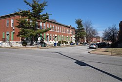 Rowhouses in JeffVanderLou, February 2018 | |
 Location (red) of JeffVanderLou within St. Louis | |
| Country | United States |
| State | Missouri |
| City | St. Louis |
| Wards | 3, 5, 6, 19 |
| Government | |
| • Aldermen |
|
| Area | |
| • Total | 1.25 sq mi (3.2 km2) |
| Population (2020)[1] | |
| • Total | 4,209 |
| • Density | 3,400/sq mi (1,300/km2) |
| ZIP code(s) | Parts of 63106, 63107, 63113 |
| Area code(s) | 314 |
| Website | stlouis-mo.gov |
In a time of racial segregation following the end of slavery, JeffVanderLou was originally designated as the city's "Negro District" and was one of the only places where African Americans were allowed to own land.
It is also where Sportsman's Park (later known as Busch Stadium I) stood from 1902 until 1966.
Demographics edit
In 2020 JeffVanderLou's racial makeup was 92.3% Black, 2.9% White, 0.5% Native American, 0.2% Asian, 3.6% Two or More Races, and 0.5% Some Other Race. 1.5% of the population was of Hispanic or Latino origin.[2]
| Year | Pop. | ±% |
|---|---|---|
| 1990 | 8,177 | — |
| 2000 | 6,459 | −21.0% |
| 2010 | 5,557 | −14.0% |
| 2020 | 4,209 | −24.3% |
See also edit
References edit
External links edit
- Neighborhood Website
- Neighborhood Plan
38°39′03″N 90°13′15″W / 38.6509°N 90.2208°W