


Summary
Jerrabomberra is a district in the Australian Capital Territory in Australia. It is situated to the southeast of Canberra Central, south of the Molonglo River, east of Woden Valley and north east of Tuggeranong and west of the New South Wales border. It includes the suburbs of Beard, Hume, Oaks Estate and Symonston and the military communications and logistics facility HMAS Harman. At the 2016 census, it had a total population of 1,240, comprising 559 in Symonston,[2] 430 in Hume (including the Alexander Maconochie Centre)[3] and 251 in Oaks Estate and Beard[1] At the 2011 census, 13 also lived in Harman.[4] It is named after Jerrabomberra Creek, which runs through it, Jerrabomberra is derived from the Aboriginal word, meaning "afraid of lightning".[5]
| Jerrabomberra Australian Capital Territory | |||||||||||||||
|---|---|---|---|---|---|---|---|---|---|---|---|---|---|---|---|
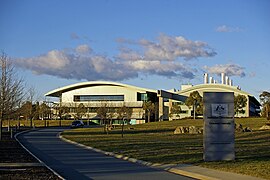 Geoscience Australia in Symonston. | |||||||||||||||
 Jerrabomberra | |||||||||||||||
 | |||||||||||||||
| Coordinates | 35°20′47″S 149°10′40″E / 35.34639°S 149.17778°E | ||||||||||||||
| Population | 1,240 (2016 census)[1][2][3] | ||||||||||||||
| Postcode(s) | 2609, 2620 | ||||||||||||||
| Territory electorate(s) | Kurrajong | ||||||||||||||
| Federal division(s) | |||||||||||||||
| |||||||||||||||
Jerrabomberra includes the "urban village" of Oaks Estate, which was formerly part of Queanbeyan, broadacre uses in Symonston (including the headquarters of Geoscience Australia and the Therapeutic Goods Administration), light industry in Hume and Symonston, HMAS Harman and rural areas. It is crossed by the Monaro Highway and Canberra Avenue.
History edit
Jerrabomberra was designated by the Districts Act of 1966[6] as one of the 18 districts of the Australian Capital Territory.
References edit
- ^ a b Australian Bureau of Statistics (27 June 2017). "Oaks Estate (State Suburb)". 2016 Census QuickStats. Retrieved 16 July 2017.
- ^ a b Australian Bureau of Statistics (27 June 2017). "Symonston (State Suburb)". 2016 Census QuickStats. Retrieved 16 July 2017.
- ^ a b Australian Bureau of Statistics (27 June 2017). "Hume (State Suburb)". 2016 Census QuickStats. Retrieved 16 July 2017.
- ^ Australian Bureau of Statistics (31 October 2012). "Harman (Statistical Local Area)". 2011 Census QuickStats. Retrieved 16 July 2017.
- ^ "Jerrabomberra Creek". Place name search. Government of the Australian Capital Territory. Retrieved 16 February 2013.
- ^ "Australian Capital Territory Districts Act 1966 (repealed)" (PDF). ACT Government. Retrieved 16 February 2014.
External links edit
- ACTMAPi