


Summary
Jhang District (Punjabi and Urdu: ضلع جھنگ) is a district of Faisalabad division in the Punjab province, Pakistan. Jhang city is the capital of district.[3][4]
Jhang District
ضلع جھنگ | |
|---|---|
 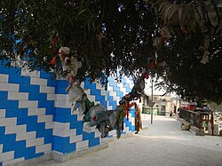 Top: Sunrise over fields Bottom: Charms neer the tomb of Heer Ranjha | |
 Flag  Seal | |
 Map of Jhang District | |
| Coordinates: 30°35′N 71°39′E / 30.583°N 71.650°E | |
| Country | Pakistan |
| Province | Punjab |
| Division | Faisalabad |
| Established | 1849[citation needed] |
| Headquarters | Jhang |
| Government | |
| • Type | District Administration |
| • Deputy Commissioner | (Cap)R Samiullah Farooq |
| • District Police Officer | N/A |
| • District Health Officer | N/A |
| Area | |
| • Total | 6,166 km2 (2,381 sq mi) |
| Population | |
| • Total | 3,077,720 |
| • Density | 500/km2 (1,300/sq mi) |
| Time zone | UTC+5 (PKT) |
| Postal Code | 40100 |
| Constituencies | NA-114, NA-115, NA-116 |
| Number of Tehsils | 5 |
| Languages | Punjabi (95%) |
| National Assembly Seats (2024) | Total (3)
|
| Punjab Assembly Seats (2024) | Total (7)
|
| Website | jhang |
Geography edit
Jhang District has a triangle-like shape, with its apex at the narrow southwestern corner and its base on the northeastern side.[4] The district is traversed by two major rivers, the Jhelum and the Chenab.[4] The Chenab generally flows towards the southwest, and it runs right down the middle of the district so that it practically divides the district into two equal parts.[4] The Jhelum enters Jhang District to the west of the Chenab and flows almost due south until it meets the Chenab at a place called the Domel.[4] The combined river takes the name Chenab, and it leaves the district just to the east of the far southwestern corner.[4]
The geography of the Jhang district can be divided into several regions, based on the course of its two major rivers.[4] First is the Hithar, or lowland areas that get flooded annually by the rivers.[4] Next, there are three distinct upland areas: the Sandal Bar, to the east of the Chenab, the Kirana Bar, between the rivers, and the Thal, which is to the west of the Jhelum.[4] These are high plateaus which slope down to the river valleys on either side.[4] Finally, between the Hithar lowlands and the Bar and Thal uplands, there is an intermediate zone called the Utar.[4] Each of these zones — Hithar, Utar, and the uplands — represents a different period of geological formation, with the uplands being the oldest, and they are all of alluvial origin.[4]
Uplands edit
Historically, the upland zones were mostly inhabited by pastoralists who grazed their herds on the wide plains here.[4] They lived in temporary habitations of thatched huts and moved around frequently.[4] Under the British Raj, most of this land was held directly by the government.[4]
The Sandal Bar edit
The easternmost upland area is the Sandal Bar.[4] In the northern parts of the district, the Sandal Bar "rises abruptly from the Utar, and the summit of the dividing ledge is from 10 to 30 feet above the plain below."[4] This sudden rise gradually lessens further south, until eventually there is no clear distinction between the Bar and the Utar.[4] The quality of the soil generally decreases towards the south, with Kallar plains more frequent, and the better types of grass such as dhaman also become rarer.[4]
The Kirana Bar edit
The Kirana Bar, which is named after the Kirana Hills, is part of the Chaj Doab between the Chenab and Jhelum rivers.[4] Like the Sandal Bar, the Kirana Bar is generally separated from the Utar by a distinct ridge, called the Nakka.[4] The flora is also similar between the two regions.[4] However, the Kirana Bar has better lands agriculturally than the Sandal Bar, and light rain showers can leave the Kirana Bar "carpeted with grass".[4] The soil gets worse to the west of the Kirana Hills, towards the Jhelum river, and more kallar soil is found.[4]
The Thal edit
Not much of the Thal is included in Jhang District, although the district boundary juts out further to include more of it south of the road connecting Jhang with Dera Ismail Khan.[4] The Thal is an elevated plateau like the Bars, but with one major difference — it is almost completely covered in sand dunes, and the underlying soil only pokes out in patches.[4] The main colour of the soil here is a light reddish brown.[4] Well-based agriculture is done in other parts of the Thal closer to the Indus, but due to the lack of access to water, there is little to no cultivation in the parts of the Thal included in Jhang district.[4] For the most part, this part of the Thal is a wasteland, dominated by rolling sand hills that run parallel to each other.[4] These are interspersed with occasional patches of good soil studded with pilu bushes, which along with some trees form just about the only greenery in sight.[4] Grass does grow abundantly after a good rain, but those only happen rarely.[4]
Utar edit
The Utar zone is very important from a human perspective because it contains most of the district's settlements.[4] The characteristics of this zone vary somewhat between several different areas:[4]
Utar of the Sandal Bar edit
This area varies in width from 4 to 16 miles, with the average usually being about 8 miles wide.[4] As with the Sandal Bar and the district as a whole, the soil gradually gets worse towards the south.[4] In general, the area closest to the river bank is the most fertile, with almost continuous areas of cultivation.[4] There are lots of wells for irrigation, each one surrounded by a cluster of trees (most commonly kikar and shisham).[4] Going further east, the wells become less frequent and they are interspersed by patches of wasteland.[4] Beyond this is the area where cattle graze.[4] Closest to the border with the Bar, the distance to water is far, and the fertility of this area varies heavily depending on rainfall.[4] Farmers try to bring rainwater down from the Bar uplands.[4]
Towards the southern end of the district, good grassland becomes less common, and trees become mostly absent except in some depressions where water collects when it rains.[4] The Chenab itself widens out in the south, and the Utar becomes more narrow.[4] Traces of river action are more common here, with more depressions and sand dunes.[4] At the far southern end of the district is a distinct area formed by relatively recent river activity; the soil here is light and sandy, and the water table is very high and close to the surface.[4] Areas here that are not under cultivated are covered by a dense growth of sar grass.[4]
Utar of the Kirana Bar edit
For the most part, the Utar on the west side of the Chenab is the same as the Utar on the east.[4] There is a similar band of well-based agriculture on this side.[4] Further west, in the Shah Jiwana taluka, the landscape changes to become either partially covered by sparse sar grass or otherwise bare kallar plains.[4]
The lowest part of the triangle between the Jhelum and the Chenab is called the Vichanh, which "may be described as a dorsal ridge, covered with efflorescent saltpetre, between the fertile low-lying alluvial lands of the two rivers."[4] This area has exceptionally sour soil and it extends as far south as Kadirpur Bakhsha.[4]
The Utar between the Jhelum and the Kirana Bar, in the area around Kot Isa Shah, is arguably the most fertile part of the district.[4] Agriculture flourishes here, and there are plenty of trees for some distance away from the river.[4] To the east, farther away from the Jhelum, is an infertile zone with lots of kallar, and then comes the Kirana Bar.[4] No clear high ridge separates this part of the Kirana Bar from the Utar.[4] The kallar plains of the border area are interspersed by some patches of fertile soil, such as the one around the village of Bhairo.[4]
Thal-Jhelum Utar (aka the Kachhi) edit
The Utar between the Thal and the Jhelum is also called the Kachhi, which refers to "a country that is contained within some strongly marked boundary, here the Thal."[4] The name is unrelated to the Urdu word kachcha meaning "unripe" or "unformed".[4] The Kachhi only really exists south of the village of Sherowana — north of here, the Jhelum flows right next to the Thal.[4] South of Sherowana, though, the Kachhi is about 9 miles wide and does not get inundated by the Jhelum's floods.[4]
A distinct feature of the Kachhi is the absence of grass.[4] The soil is clayey, and water does not penetrate it but instead drains off into depressions.[4] The salts left behind prevent the growth of plants, and the surface is barren as a result.[4] The Kachhi does, however, support a "stunted forest" of jal bushes close to the Thal, and karir closer to the river.[4]
Hithar edit
The upper Chenab valley edit
The upper Chenab, before receiving the waters of the Jhelum at the Domel, is "a broad shallow stream, with a sluggish current and a licentious course.[4] Its deposits are sandy, but its flood is extensive, and from the loose texture of the soil on its banks, the moisture penetrates far inland."[4] The upper Chenab is contained between two well-defined banks and it rarely spills over them except at certain known points.[4] The width between these two banks varies significantly throughout the river's course.[4] In areas where the banks are fairly close together, the whole area between them is reliably flooded each year.[4] In areas where the river has eroded more of the Utar and the banks are farther apart, however, the flood patterns are less predictable.[4] In these places, in order to ensure that the water floods fields, people set up embankments across the nalas to raise the water level.[4] The deposits left behind by the Chenab are usually very sandy, and they usually require successive deposits of silt in order to become good for agriculture.[4] This tendency has led to a saying, "it takes gold and gives copper."[4] The upper Chenab has "enormous powers of erosion" but it works slowly, and its flooding is fairly regular.[4]
The Jhelum valley edit
Compared to the Chenab, the Jhelum contains a much smaller volume of water, and it flows in a much narrower channel.[4] Since it is a fairly narrow river, islands are uncommon.[4] The Jhelum floods a smaller area than the Chenab, but its deposits are much richer: more mud and less sand.[4] A deposit of Jhelum silt can yield a good rice crop in its first year, unlike the Chenab.[4] The zone on the banks of the Jhelum is "fertile, well wooded, densely cultivated, and supports a larger population than any other portion of the district."[4]
The lower Chenab valley edit
Immediately downstream from the Domel, the lower Chenab begins to flood a much larger area.[4] Large islands (called belas or bindis) form much more frequently than they do upstream.[4] There are many channels of the river that are dry during cold weather and fill up with water whenever the water level rises.[4] A thick lai jangal grows along the riverbank, mixed with patches of cropland.[4] Between this band and the boundary of the Utar zone is the alluvial plain flooded by the river each year.[4] This area is heavily cultivated, mostly for Rabi crops — generally only higher, lighter soils are used to grow autumn crops.[4] The soil in this zone ranges from stiff clay to sand, but usually tends to be a light loam, "easily worked and retentive of moisture."[4]
Below Shorkot, the Utar recedes, and instead of a relatively narrow band of Hithar lowlands, there is a wide floodplain with many channels that carry floodwaters inland.[4] There is a narrow band of rich sailab land along the riverbank.[4] Beyond this, higher ground and patches of sandy sar-covered wasteland become common.[4] Wells for irrigation also become more common farther away from the river.[4]
In February or March the view of this cis-Chenab portion of the district from an old mound or eminence has a peaceful beauty peculiar to itself. A sea of yellow grass rippling in the breeze, edged on the west by a silver ribbon of river, are the features that first strike the eye. Dotted over the surface are dark clumps of trees round the wells, and here and there a few groves of date palms. Towards the river long stretches of wheat are to be seen, while nearer in the cultivation is hidden from view, or only peeps out near a well or where a piece of sailáb cultivation larger than usual is found. Beyond the river rise dark against the horizon the trees growing round villages that fringe the further bank.
— Gazetteer of the Jhang District (1883), pp. 9-10[4]
Climate edit

The climate of Jhang District is the same as the climate for all of southern Punjab.[4] At the start of June, the weather becomes intensely hot, and the kikar and ber trees lose all their leaves due to the heat.[4] A hot wind blows consistently from the south and southwest throughout the month of June; the wind becomes more variable with the onset of the monsoon.[4] Until the last few days in June, the nights are somewhat cooler than the days, and from that point on both day and night are very hot.[4]
The monsoon rains generally start by mid-July, and then they fall constantly with few if any pauses.[4] The rains bring a drop in temperature, and the lack of muggy weather makes Jhang District more pleasant during this period than some other areas.[4] Any pause in the rains, though, and the heat becomes intense again.[4] The next major change usually happens in August, when the nights and mornings get cooler.[4] When the cold weather begins depends on the amount of rainfall during August and September: if there is no rain, then the cooling happens more gradually and people stop using pankhas around early-mid October.[4] With rain, the cold weather begins much more quickly.[4]
Like in the rest of Punjab, cold weather in Jhang District is characterised by crisp, fresh mornings; cool, bright days; and frosty nights.[4] Rain generally does not fall during October and November, but it does at the end of December as well as during January and February.[4] By the end of March, it gets noticeably warmer; April and May are both hot and dry.[4]
Plants edit
Trees edit

The most common tree in Jhang District is the kikar (Acacia arabica), especially in the Hithar zone along the Jhelum and Chenab rivers.[4] It grows quickly, which is the main reason why it is generally preferred as a wood tree.[4] It is vulnerable to frost when young, but less so when mature.[4] The tree's pods and loppings from pruning are readily eaten by sheep and goats.[4] Kikar wood is very high quality and traditionally was used for practically every purpose, especially making wooden wheels.[4] The bark, meanwhile, is traditionally used in tanning as well as to make spirits.[4] The Kabuli kikar (Acacia cupressiformis) is also common in Jhang District, but it is less valued for human use.[4]
The shisham (Dalbergia sissu), also called the tahli, is found wherever there is cultivated land, but since its roots need to get down to water for it to thrive, it is most abundant in the Hithar lowlands along the rivers.[4] Particularly in the southern Hithar, just about every well has a bunch of shishams growing around it, and many of them can get quite big.[4] The shisham can be found either growing straight or drooping.[4]
The ber (Ziziphus jujuba) is a hardy tree, and it will grow just about anywhere, although it does best in the fertile soil of the Hithar.[4] It is considered unlucky to cut down a ber, and its fruit is held in high regard.[4] The fruit ripens around March, and it has an acidic taste.[4]
The ukanh (Tamarix orientalis), also called the farash or the khagal, is not common except in the Bars and the Kachhi.[4] In the Kachhi, ukanh are usually gnarled and stunted except around wells, and they are usually not chosen to be planted by people.[4] In the Bars, the ukanh is a common sight wherever water collects or the soil is moister than usual.[4] Its wood is hard and used for various purposes.[4]
The jand (Acacia leucophelea) is usually encountered as a stunted bush or shrub, but in more conducive conditions it can grow into a large tree.[4] The presence of jand shrubs is a sign of good underlying soil.[4] Jand jangal is uncommon in the Hithar, also a dense area of it once existed near Shorkot.[4] Like the ukanh, jands growing in the Bars generally prefer moist, low-lying areas.[4]
The sohajna, or horseradish tree (Moringa pterygosperma), is found throughout the district, but is especially common in the Jhang tehsil.[4] It gets pruned regularly every year, and its fruit is preserved and used in chutneys as well as to make pickles.[4]

The jal (Salvadora oleoides), also called the wan or pilu, is very common throughout the district, with the largest trees generally being found in the Kachhi and the Bars.[4] It is known by all three names, but its fruit is exclusively called pilu.[4] There are two kinds of jal tree: the kaura jal and the miththa jal.[4] The kaura jal's leaves are much darker, longer, and wider than the mitha jal's leaves.[4] Cobras especially like to hide under the jal tree's roots, and camels like to eat its leaves during the first part of the hot season.[4] The jal is well-regarded for giving good shade.[4] Historically, cattle thieves in the Bars would frequently hide stolen animals under jal trees.[4] The jal does not make good firewood — it produces "an enormous quantity of ash", it stinks when burned, and it doesn't give off much heat.[4] The pilu fruit, though, is enjoyed both by people and by animals.[4] It usually ripens around the beginning of June, and it gets gathered, dried, and stored.[4] Livestock that eat the pilu fruit are supposed to produce sweeter milk, and more of it.[4]

The karir bush (Capparis aphylla) grows alongside the jal throughout the district.[4] Like the jal, it is especially common in the Kachhi and Bar regions.[4] Sheep and goats readily graze off the karir, and cows will do so as well when other food is hard to come by.[4] It has a pinkish-white flower called the bata, as well as a berry called the dehla.[4] The dehla is eaten when ripe, but not extensively, and it is nowhere near as esteemed as ber or pilu fruit.[4] The unripe berries are pickled or made into a tonic for horses.[4] Karir wood is less susceptible (but not immune) to infestation by white ants than other types of wood found in the district; it gets used to make rafters for houses.[4]
Other trees that are found in Jhang District include the siris (Acacia speciosa), which is rare but gives good shade; the bohar (Ficus indica), which is found throughout the district but especially thrives near the rivers; the pipal (Ficus religiosa), which is found throughout the district but less commonly than the bohar; the bakain (Melia azaderach); and the bahn (Populus euphratica, locally called the ubhan), which is found on some river islands, particularly just above the Domel.[4]
Shrubs edit

One of the most significant plants found in Jhang District is the buta (Tripidium bengalense, syn. Saccharum munja), which is extremely common in the Chenab valley but not so much along the Jhelum.[4] It gets more common the further south you go.[4] Different parts of the plant go by different names: the leaves are called sar, the flower stems are called kana and tili, and the stem sheaths are called munj.[4] In October and November, before the kana stems are cut, they crowd one's view, and the difference after they are cut is "astonishing".[4] During the cold season, cattle almost exclusively eat these plants.[4] Every part of the buta plant has human uses, but the most important is the munj, which gets made into rope.[4]
Kanh (Saccharum spontaneum) is only found in the moistest areas along the rivers.[4] It makes the thickest jangal in the district, and it is especially liked by buffaloes for grazing as well as by wild pigs.[4] It gets used to make pens, but not for thatching because it's too valuable.[4]
Lana, lani, and khar are all found in Jhang District, and they are all eaten by camels.[4] Khar is the most preferred, and lani the least.[4] Lana comes in two varieties, called gora and mithar.[4] Khar is used to make sajji.[4]
Phog is mostly found in the Thal and in sandy parts of the Bars.[4] It is rarely eaten by cattle, and it has no human use.[4] Buin and khip are similarly useless to humans, and animals do not eat them.[4] Ak is sometimes eaten by goats and deer if they get desperate, and it is also not useful to humans.[4] Jawanh, or the camelthorn, is mostly found in the waste and fallow lands that get flooded by the rivers; it is a weed that causes problems for agriculture.[4] The leh, or thistle, is another weed that grows in old sailab lands.[4] Two more problematic weeds are the harmal and the bhukil, which are found throughout the Kachhi areas under well-based agriculture.[4] The harmal mostly grows on fallow lands, while the bhukil grows in light sandy soil alongside crops, and it "chokes" the crops and kills them.[4]
Grasses edit
Grasses are important in Jhang District because they form pasturage for livestock.[4] The most common grass in the district is the chhimbar, which thrives in all types of soil.[4] It grows densely, and with good rainfall it can get very tall.[4] Lamb is a feathery grass that grows in kallar.[4] Lunak also grows in kallar; it is tall and high quality and requires a good deal of rain to thrive.[4] Garham somewhat resembles lunak in appearance, but is taller and stronger.[4] It does not grow in kallar soil, but instead usually grows under bushes that have been fertilised by dung.[4] It is not as good as lunak.[4] Kurya is an uncommon grass, but it is high quality and makes especially good grazing for horses.[4] Khar madhuna is a smaller grass, inferior in quality.[4] Its seeds are shaped like a woodlouse.[4]
The best grass of all is dhaman, which grows more in the north and less in the south.[4] It will not grow on kallar soil.[4] It is "a thick, juicy, pale green grass" that gets very tall with enough rain.[4] It supposedly makes buffalo milk slightly intoxicating if they graze on it.[4] Another good grass is pilan, which makes sweet hay and grows mixed with chhimbar and kheo.[4] Kheo sprouts exceptionally quickly after rains; it is higher quality than murak, which also has this trait.[4] Aleti, dedhak, and kilanj are three prostrate grasses that grow in Jhang District; all three of them are very hardy and do well during droughts.[4] Sheep and goats eat them on the ground, while people dig them up and feed them to cattle.[4]
Khawi grass grows in hollows where water collects, and tends to favour kallar soil.[4] It has a fragrant smell and is coloured dark brownish-red.[4] Cows will eat it, but only when desperate, because it is not very nutritious.[4] Khawi grass is used to make khas-khas.[4] Like khawi, panhi grass grows in hollows and depressions, but it sticks to better soils and does not grow in kallar.[4] It somewhat resembles the buta in shape, although it is straight and stiff instead of drooping like the buta.[4] Its roots are long and tough, and they are used to make rope as well as to make weavers' brushes.[4]
Animals edit
Wolves are found in both the Sandal Bar and the Kirana Bar, and historically they were fairly common.[4] Hyenas live here but have never been common.[4] Two types of wild cats live in the district, and both of them are called the bar-billa.[4] One type is distinguished by its long tail and is actually descended from domesticated cats that became feral.[4] It grows larger than domesticated cats, and can run especially fast.[4] The other type, distringuished by its short tail, is a true lynx.[4] Jackals historically were found along the Chenab "in great numbers", but not so much in the Bars.[4] Two different kinds of foxes also live in the district: one is a light yellowish-brown colour, and it blends in with the ground after a drought; the other one is darker in colour.[4] Wild pigs and hares also live in Jhang District.[4]
Birds found in the district include the houbara, which is called the obara here and is especially common throughout the district during the colder months; the coulon, or kunj, which comes here during the cold season and is most common in Hithar areas; and geese, which migrate here later than the coulon and are most common along the banks of the Jhelum and the lower Chenab.[4] The sandgrouse is common throughout the district in November and December, and the quail is common in spring and autumn.[4]
The most common snakes in the district include the karet and the cobra.[4] The Bars especially are home to a large variety, including many venomous ones.[4]
Administrative divisions edit
History edit
The early history of Jhang District is unclear.[4] It is heavily intertwined with the historically dominant Sial tribe, who founded the city of Jhang in 1462.[4] But they were not particularly powerful until the first half of the 18th century — they were originally just one of several pastoral tribes living in the area, and they were tributaries of the more powerful Nauls.[4] Babur does not mention the Sials at all in the early-16th-century Baburnama, although he does refer to the regions of Bhera, Khushab, Chiniot, Chenab, and (possibly) Shorkot.[4] Gradually, however, the Sials gained preeminence over the other tribes and came to collect tribute from them.[4]
Various independent branches of the Sials existed up until the reign of Walidad Khan in the early 18th century (the exact date is not clear).[4] Walidad Khan inherited rulership of the branch based at Jhang's fort, but he only ruled a small area at first.[4] Other branches of the Sials at the time were based at Rashidpur, across the Chenab and close relatives (and allies) of Walidad Khan; at Massan in the Vichanh, whose ruler belonged to the Sahibana branch; and at Mirak Sial to the south, whose ruler was part of the Nithrana branch.[4] Other independent rulers included the Mahnis of Khiwa, the Sayyids of Shah Jiwana, the Rihans of Kalowal, and the Kharals of Kamalia.[4]
Walidad Khan was a successful ruler who ended up ruling over a large kingdom with Jhang as his capital.[4] He died in 1747 and was succeeded as ruler by Inayatullah Khan, who was his nephew and son-in-law.[4] Inayatullah Khan was also skilled as an administrator and military leader, but the ascendant Sikh Confederacy was beginning to impose its authority over this region.[4] In 1760, Hari Singh of the Bhangi Misl sacked Jhang and made Inayatullah into his tributary; Inayatullah suspended paying tribute in 1778 and captured Chiniot from the Bhangis, but it had apparently come back under their control by the time he died in 1787.[4]
Ranjit Singh, founder of the Sikh Empire, captured Chiniot from the Bhangis in 1803 and intended to attack Jhang, but the reigning Sial leader Ahmad Khan agreed to become his tributary before he did so.[4] He paid an annual tribute of 70,000 rupees and one mare for a couple of years before Ranjit Singh invaded again.[4] Ahmad Khan offered to pay him nazarana, but Ranjit Singh refused and went on to capture Jhang.[4] Ahmad Khan fled to Multan, where he found refuge with the Nawab, Muzaffar Khan.[4] Meanwhile, Ranjit Singh parcelled out the tax farming rights for the conquered Sial territory among his followers: the Vichanh area was given jointly to Dyal Singh and Fateh Singh Lamah, while the rest went to Fateh Singh Kalianwala.[4]
Ahmad Khan and Fateh Singh Kalianwala reached an agreement in 1808; Ahmad Khan was reinstated as ruler of his former lands (at least the part that Fateh Singh held) in return for an annual payment of Rs. 70,000.[4] Ahmad Khan then drove out the Sikh governors of the Vichanh.[4] However, this arrangement did not last for long: after accompanying Ranjit Singh on an unsuccessful expedition against Multan in 1810, Ahmad Khan was imprisoned and taken to Lahore because Ranjit Singh suspected him of favouring the Nawab of Multan.[4] Lala Sujan Rai was then appointed governor of Jhang.[4] Ahmad Khan was later released and given a jagir of Rs. 1,200 at Mirowal near Amritsar; he later died in 1820.[4]
The British annexed the Punjab in 1849 at the end of the Second Anglo-Sikh War, and at that point Jhang was constituted as one of the districts of Punjab.[4] It was divided into the following tehsils and talukas:[4]
| Tehsil | Taluka |
|---|---|
| Chiniot Tehsil | |
| Jhang Tehsil | |
| Kadirpur Tehsil |
|
| Peshkari of Uch |
|
In 1854, the Faruka taluka in the Chaj Doab was transferred out of Jhang District and into Shahpur District, and at about the same time a long strip of land on the right bank of the Ravi River was transferred out of Jhang District and into Multan District.[4] In 1861, the ilakas of Garh Maharaja and Ahmadpur were transferred from Muzaffargarh District into Jhang District, and the ilaka of Kalowal was transferred from Shahpur District into Jhang District.[4] At around the same time, Jhang District was redivided into three tehsils: Jhang, Chiniot, and Shorkot.[4] Then in 1880, five villages were transferred out of Shorkot Tehsil in Jhang District and placed in the Sarai Siddhu of Multan District, so as to give Multan District control of the entire Ravi sailab.[4]
Demographics edit
Population edit
| Year | Pop. | ±% p.a. |
|---|---|---|
| 1951 | 534,046 | — |
| 1961 | 668,540 | +2.27% |
| 1972 | 983,818 | +3.57% |
| 1981 | 1,276,864 | +2.94% |
| 1998 | 1,869,421 | +2.27% |
| 2017 | 2,742,633 | +2.04% |
| 2023 | 3,077,720 | +1.94% |
| Sources:[6] | ||
At the time of the 2017 census, Jhang district had 426,845 households and a population of 2,742,633. Jhang had a sex ratio of 966 females per 1000 males and a literacy rate of 55.64% - 68.06% for males and 42.93% for females. 598,432 (21.82%) lived in urban areas. 790,829 (28.83%) were under 10 years of age.[7] In 2023, the district had 494,761 households and a population of 3,077,720.[2]
Religion edit
As per the 2017 census, Muslims made up almost the entire population with 99.70%.[7]
| Religious group |
1941[8]: 42 | 2017 | ||||||||
|---|---|---|---|---|---|---|---|---|---|---|
| Pop. | % | Pop. | % | |||||||
| Islam |
401,991 | 79.85% | 2,734,493 | 99.7% | ||||||
| Hinduism |
90,670 | 18.01% | 195 | 0.01% | ||||||
| Sikhism |
10,050 | 2% | — | — | ||||||
| Christianity |
721 | 0.14% | 4,900 | 0.18% | ||||||
| Ahmadi | — | — | 1,623 | 0.06% | ||||||
| Others | 16 | 0% | 1,422 | 0.05% | ||||||
| Total Population | 503,448 | 100% | 2,742,633 | 100% | ||||||
| Note: 1941 data is for Jhang and Shorkot tehsils of Jhang district, which roughly corresponds to the present Jhang district. | ||||||||||
| Religious group |
1901[9] | 1911[10][11] | 1921[12] | 1931[13] | 1941[14] | |||||
|---|---|---|---|---|---|---|---|---|---|---|
| Pop. | % | Pop. | % | Pop. | % | Pop. | % | Pop. | % | |
| Islam |
295,481 | 78.03% | 422,468 | 81.95% | 475,388 | 83.32% | 552,853 | 83.16% | 678,736 | 82.61% |
| Hinduism |
79,650 | 21.03% | 73,426 | 14.24% | 85,339 | 14.96% | 102,990 | 15.49% | 129,889 | 15.81% |
| Sikhism |
3,526 | 0.93% | 19,427 | 3.77% | 9,376 | 1.64% | 8,476 | 1.27% | 12,238 | 1.49% |
| Christianity |
38 | 0.01% | 201 | 0.04% | 449 | 0.08% | 494 | 0.07% | 763 | 0.09% |
| Jainism |
0 | 0% | 4 | 0% | 7 | 0% | 0 | 0% | 5 | 0% |
| Zoroastrianism |
0 | 0% | 0 | 0% | 0 | 0% | 20 | 0% | 0 | 0% |
| Buddhism |
0 | 0% | 0 | 0% | 0 | 0% | 0 | 0% | 0 | 0% |
| Judaism |
0 | 0% | 0 | 0% | 0 | 0% | 0 | 0% | 0 | 0% |
| Others | 0 | 0% | 0 | 0% | 0 | 0% | 0 | 0% | 0 | 0% |
| Total population | 378,695 | 100% | 515,526 | 100% | 570,559 | 100% | 664,833 | 100% | 821,631 | 100% |
| Note: British Punjab province era district borders are not an exact match in the present-day due to various bifurcations to district borders — which since created new districts — throughout the historic Punjab Province region during the post-independence era that have taken into account population increases. | ||||||||||
Language edit
At the time of the 2017 census, 94.11% of the population spoke Punjabi and 4.10% Urdu as their first language.[7]
Historical settlement patterns edit
From the Census Report of 1881: the average size of a village was 474 people, the average distance between villages was 2.98 miles, and the average number of villages per 100 square miles was 13.[4] The overall population density per square mile was just 69 people (63 in rural areas excluding cities), but this statistic was "in a manner misleading", since it counted large areas of arid steppe with very low populations of nomadic pastoralists.[4] The area that was under cultivation, on the other hand, was actually fairly dense, with 557 people per square mile in rural areas (615 per square mile if urban areas are included).[4] The average number of families per house was 1.22 in villages and 1.94 in towns; the average number of people per house was 5.74 in villages and 8.05 in towns; and the average number of people per family was 4.71 in villages and 4.14 in towns.[4]
Historically, most villages in Jhang district were very dispersed.[4] Instead of having a single village site, landlords and their tenants would have houses around individual wells in small hamlets, along with a shopkeeper and a few Kamins (craftsmen, service providers, and other specialists).[4]
Educational institutes edit
Following are some of the notable educational institutes of the district:
Notable people edit
- Sultan Bahoo, a Sufi saint
- Abdus Salam, Nobel Prize winner in physics
- Muhammad Arif Khan Rajbana Sial, politician, close associate of the Quaid-e-Azam and key figure in the Independence Movement of Pakistan
- Aleem Dar, cricket player
- Muhammad Tahir-ul-Qadri, a Sufi Scholar, Politician, Founder of Minhaj-Ul-Quran International and Pakistan Awami Tehreek
- Majeed Amjad, a famous Urdu Poet
References edit
- ^ a b c Jhang on Punjab Portal, Punjab Government website Retrieved 15 April 2021
- ^ a b "TABLE 1 : HOUSEHOLDS, POPULATION, HOUSEHOLD SIZE AND ANNUAL GROWTH RATE" (PDF). www.pbscensus.gov.pk. Pakistan Bureau of Statistics. 2023.
- ^ "Tehsils & Unions in the District of Jhang – Government of Pakistan". National Reconstruction Bureau, Government of Pakistan website. 2 January 2007. Archived from the original on 12 February 2008. Retrieved 15 April 2021.
- ^ a b c d e f g h i j k l m n o p q r s t u v w x y z aa ab ac ad ae af ag ah ai aj ak al am an ao ap aq ar as at au av aw ax ay az ba bb bc bd be bf bg bh bi bj bk bl bm bn bo bp bq br bs bt bu bv bw bx by bz ca cb cc cd ce cf cg ch ci cj ck cl cm cn co cp cq cr cs ct cu cv cw cx cy cz da db dc dd de df dg dh di dj dk dl dm dn do dp dq dr ds dt du dv dw dx dy dz ea eb ec ed ee ef eg eh ei ej ek el em en eo ep eq er es et eu ev ew ex ey ez fa fb fc fd fe ff fg fh fi fj fk fl fm fn fo fp fq fr fs ft fu fv fw fx fy fz ga gb gc gd ge gf gg gh gi gj gk gl gm gn go gp gq gr gs gt gu gv gw gx gy gz ha hb hc hd he hf hg hh hi hj hk hl hm hn ho hp hq hr hs ht hu hv hw hx hy hz ia ib ic id ie if ig ih Punjab Government (1883). Gazetteer of the Jhang District. Lahore: Arya Press. pp. 1–22, 40–1, 46–7. Retrieved 13 July 2021.
- ^ "Administrative Units of Pakistan (Tehsils/Talukas)". Statistics Division, Ministry of Economic Affairs and Statistics, Government of Pakistan. 10 February 2004. Archived from the original on 30 December 2010. Retrieved 15 April 2021.
- ^ "Population by administrative units 1951-1998" (PDF). Pakistan Bureau of Statistics.
- ^ a b c d "District Wise Results / Tables (Census - 2017)". www.pbscensus.gov.pk. Pakistan Bureau of Statistics. Archived from the original on 7 April 2022.
- ^ "CENSUS OF INDIA, 1941 VOLUME VI PUNJAB PROVINCE". Retrieved 22 July 2022.
- ^ "Census of India 1901. [Vol. 17A]. Imperial tables, I-VIII, X-XV, XVII and XVIII for the Punjab, with the native states under the political control of the Punjab Government, and for the North-west Frontier Province". 1901. p. 34. JSTOR saoa.crl.25363739. Retrieved 29 March 2024.
- ^ "Census of India 1911. Vol. 14, Punjab. Pt. 2, Tables". 1911. p. 27. JSTOR saoa.crl.25393788. Retrieved 29 March 2024.
- ^ Kaul, Harikishan (1911). "Census Of India 1911 Punjab Vol XIV Part II". p. 27. Retrieved 23 March 2024.
- ^ "Census of India 1921. Vol. 15, Punjab and Delhi. Pt. 2, Tables". 1921. p. 29. JSTOR saoa.crl.25430165. Retrieved 29 March 2024.
- ^ "Census of India 1931. Vol. 17, Punjab. Pt. 2, Tables". 1931. p. 277. JSTOR saoa.crl.25793242. Retrieved 29 March 2024.
- ^ "Census of India, 1941. Vol. 6, Punjab". 1941. p. 42. JSTOR saoa.crl.28215541. Retrieved 29 March 2024.
- ^ Chenab College, Jhang
- ^ Punjab Group of Colleges website
- ^ a b 1931-1941: Including Ad-Dharmis
Bibliography edit
- 1998 District Census report of Jhang. Census publication. Vol. 114. Islamabad: Population Census Organization, Statistics Division, Government of Pakistan. 2000. Archived from the original on 20 December 2016. Retrieved 13 December 2016.
- Wagha, Muhammad Ahsan (1997). The development of Siraiki language in Pakistan (Ph.D.). School of Oriental and African Studies.
- Maloomat e Jhang Complete Book