


Summary
Jogindernagar, or Jogindar Nagar ([dʒoːˈɡɪnd̪ər nəˈɡər]), is a municipality, and a sub district in Mandi district in the Indian state of Himachal Pradesh. Named after Raja Joginder Sen, the hill station is the terminus of the 163-kilometre-long (101 mi) Kangra Valley narrow-gauge railway. Jogindernagar is the third-largest city in the Mandi district. The only city in Asia with three hydro-electric power stations, its nickname is "The City of Powerhouses".[3]
Joginder Nagar
The City of Powerhouses | |
|---|---|
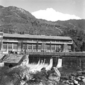
 Jogindernagar and its suburbs, seen from Siqandar Dhar | |
| Nickname(s): Electric City, City of Powerhouses | |
 Joginder Nagar Location in Himachal Pradesh, India  Joginder Nagar Joginder Nagar (India) | |
| Coordinates: 31°59′19″N 76°47′30″E / 31.988723°N 76.79155°E | |
| Country | |
| State | |
| District | Mandi |
| Nearest city | Mandi city |
| Formation | 1925 |
| Founded by | Joginder Sen |
| Named for | King of Mandi |
| Government | |
| • Body | Municipal council |
| • MLA | Prakash Rana (Bharatiya Janata Party) |
| Area | |
| • Total | 107 sq mi (278 km2) |
| Elevation | 4,000 ft (1,220 m) |
| Population (2022) | |
| • Total | 108,122 |
| • Rank | 20 in state |
| • Density | 1,000/sq mi (390/km2) |
| Languages | |
| • Official | Hindi, English, Mandyali |
| Time zone | UTC+5:30 (IST) |
| PIN | 175015[1] |
| Telephone code | 1908[2] |
| Vehicle registration | HP-29 |
| Literacy | 87.86% |
| Climate | Humid subtropical (Köppen) |
| Avg. annual temperature | 18 °C (64 °F) |
| Avg. summer temperature | 24 °C (75 °F) |
| Avg. winter temperature | 10 °C (50 °F) |
| Website | jogindernagar.com |
Situated in the central Joginder Nagar Valley, this region is known for paragliding and trekking, mountain biking and camping. The valley is known for its Ts: trolley, trout and train. In 2015, Jogindernagar was declared the first free Wi-Fi city in Himachal Pradesh.[4]
Etymology edit
Jogindernagar was named after the Mandi king Raja Joginder Sen. Its original name was Sukrahatti.
History edit
In 1925, Raja Joginder Sen and Col. B. C. Batty planned a hydropower scheme near the village of Sukrahatti. Alexander Sanderson was chief engineer until December 1929, when he returned to England with the project half-completed.[5][better source needed] Narrow-gauge railway track was laid from Pathankot to Jogindernagar—about 150 kilometres (93 mi)[6]—to carry heavy machinery transported from Britain. A haulage system was laid from the Shanan Power House site to Barot, where a reservoir was built on the Uhl River. After tunneling and piping the water several kilometres from the river to Jogindernagar, the 110-MW Shanan Power House was built by a team of engineers headed by Batty. It was the only hydroelectric project in northern India which fed undivided Punjab and Delhi.
The hydroelectric scheme planned to build five power stations with water from the Uhl River. Water from the Shanan Power House was to be taken by tunnels 8 kilometres (5.0 mi) to adjoining Siyuri Dhar. A reservoir was to be built in the village of Chapprot to drive turbines at the base of Chapprot Hill in stage two of the project. However, the plan was abandoned after Batty's death.
During the 1960s, the Himachal Pradesh State Electricity Board revived the plan. Another set of turbines was added at Bassi (a small village at the bottom of Chapprot Hill) in 1970, and the 66-MW Bassi Power House was built. Despite the Bassi Power House's economy (since it was based on tailwater from the Shanan project), no further development was made until the beginning of the 21st century. Construction of the project's third stage, the 100-MW Uhl Stage III, is ongoing in the village of Chulla (near Tullah) with two reservoirs: one near Machhyal Lake and another in the village of Raktal (near Chulla).
Until the mid-20th century, Jogindernagar was northern India's largest potato market.[7] The potato-growing valleys were not linked by roads; over 2,000 mules from the Lahaul and Spiti valleys transported potatoes from outlying areas to Jogindernagar, the only railhead in that part of the state. Potatoes from Mandi, Kullu and Lahaul and Spiti districts were brought there for transport to West Bengal.
Rock salt edit
Jogindernagar was India's only supplier of rock salt, obtained from the Gumma and Drang mines. Residents of the Kullu Valley travelled for days to obtain the salt, crossing the high-altitude Bhubhu Pass (since the road network did not yet exist).
These mines were started in May 1963 and closed in January 2011, due to non-forest clearance from the environment and forest ministry and non-deposit of royalty by the company. However, after re-commissioning in March 2016, the rock salt mine was extracting around 1,500 tonnes of salt every year from Maigal, Darang and Gumma mines.[8]
Geography edit
Jogindernagar is in the central Joginder Nagar Valley, in the north-western Himalayas.[9] Surrounded by mountains, it has an average elevation of 1,220 metres (4,000 feet). Jogindernagar's altitude ranges from 800 metres (2,600 ft) on the southern valley floor to 3,000 metres (9,800 ft) on the northern hilltops.
Its surrounding mountains are covered with dense pine forests. Rhododendron (burans, known locally as brah ka fool) and deodar trees are found at high-altitude locations such as Winch Camp, Jhatingri and Phuladhar. Jogindernagar is in a Zone V (very high earthquake-damage risk) region, and after-effects of the 1905 earthquake are still visible at the nearby Kila Karanpur fort.
Climate edit
The climate is warm and temperate; summer is much rainier than winter. According to the Köppen climate classification, Jogindernagar has a humid subtropical climate (Cwa). Its average annual temperature is 18.2 °C (64.8 °F), and its average annual rainfall is 1,851 millimetres (72.9 in).
November is the driest month, with 25 millimetres (0.98 in) of rain. The wettest month is July, with an average of 474 millimetres (18.7 in). The warmest month is June, with an average temperature of 26.5 °C (79.7 °F); January is the coldest, with an average temperature of 8.1 °C (46.6 °F). The difference in precipitation between July and November is 449 millimetres (17.7 in), and the variation in temperature throughout the year is 17.4 °C (63.3 °F).
Winter temperature may fall to −4 °C (25 °F) in Jogindernagar and −10 °C (14 °F) at higher altitudes, which receive heavy snowfall from December to March; Jogindernagar receives occasional snow. Although summers are warm, the maximum temperature rarely exceeds 34 °C (93 °F); the record high is 38 °C (100 °F).
| Climate data for Jogindernagar | |||||||||||||
|---|---|---|---|---|---|---|---|---|---|---|---|---|---|
| Month | Jan | Feb | Mar | Apr | May | Jun | Jul | Aug | Sep | Oct | Nov | Dec | Year |
| Mean daily maximum °C (°F) | 14.6 (58.3) |
17.4 (63.3) |
21.8 (71.2) |
25.1 (77.2) |
31.7 (89.1) |
32.6 (90.7) |
28.0 (82.4) |
27.0 (80.6) |
27.1 (80.8) |
25.0 (77.0) |
21.2 (70.2) |
17.2 (63.0) |
24.1 (75.3) |
| Daily mean °C (°F) | 8.1 (46.6) |
12.6 (54.7) |
16.8 (62.2) |
18.6 (65.5) |
24.2 (75.6) |
25.5 (77.9) |
24.6 (76.3) |
23.8 (74.8) |
22.2 (72.0) |
17.1 (62.8) |
14.9 (58.8) |
10.4 (50.7) |
18.2 (64.8) |
| Mean daily minimum °C (°F) | 2.7 (36.9) |
4.9 (40.8) |
8.8 (47.8) |
12.1 (53.8) |
17.7 (63.9) |
19.5 (67.1) |
20.2 (68.4) |
20.6 (69.1) |
17.3 (63.1) |
12.3 (54.1) |
8.6 (47.5) |
4.6 (40.3) |
12.4 (54.4) |
| Average precipitation mm (inches) | 114 (4.5) |
94 (3.7) |
120 (4.7) |
61 (2.4) |
62 (2.4) |
108 (4.3) |
474 (18.7) |
456 (18.0) |
226 (8.9) |
63 (2.5) |
25 (1.0) |
48 (1.9) |
1,851 (73) |
| Source: Climate-Data.org, altitude: 1179m[10] | |||||||||||||
Demographics edit
Population edit
As per 2022 estimates, the population of the Jogindernagar sub district or tehsil is 108,122[11] including 214 urban and rural locations. The combined population of Vidhan Sabha constituency inclusive of two sub districts viz. Jogindernagar (108,122) and Lad Bharol (33,065)[12] is 141,187.
According to the 2011 Census of India, the Jogindernagar sub district had a population of 84,470,[13] of which 41,245 were male and 43,225 were female showing a population growth of 28 percent when compared to 2022 figure. While, the notified municipality had a population of 5,335 and is divided into seven wards, for which elections are held every five years.
Literacy edit
Jogindarnagar's literacy rate is 87.86 percent, higher than the Himachal Pradesh average of 82.80%. Male literacy is 92.63 percent, and female literacy is 82.99 percent.
Religion edit
The major religion is Hinduism; a small percentage of the population follows Islam, Sikhism, Christianity and Tibetan Buddhism. A Tibetan Buddhist community (including monks) lives in the nearby village of Chauntra.
Languages edit
The major languages spoken in the region are Hindi and the Western Pahari varieties of Mandyali and the Kangri dialect. Most residents also speak English.
Cityscape edit
The urban agglomeration (UA) including around 50 urban and suburban areas is spread across the slopy plains of Joginder Nagar valley within an area of 60 square kilometers. The combined population of Joginder Nagar UA is estimated at 50,000 as of 2023. Rest of the population of around 60,000 lies in steep hills and rural areas mostly in the form of villages.
Major Suburbs edit
- Luxmi Bazaar
- College Area
- Samlot
- Upper Seri
- Lower Seri
- Shanan
- Garoru
- Jhalwan
- Balakrupi
- Masoli
- Aarthi
- Jalpeher
- Dhelu
- Dheluhar
- Dohag
- Bharyara
- Harabagh
- Harganen
- Machyal
- Majharanu
- Ner Gharwasda
- Palhoon
- Dhrun
- Chattar
- Bassi
- Yora
- Jimjema
- Ghamrehar
- Majhwar
- Dart Bagla
- Banaee
- Dibhnoo
- Khuddar
Other Suburbs edit
- Bhararu
- Chauntra
- Sarli
- Sukhabag
- Ahju
- Ladruhi
- Dakbadga
- Sainthal
- Kohra
- Bhaterh
- Sarohli
- Raja
- Sagnehr
- Tikroo
- Tikri Musehra
- Machkehr
- Talkehr
- Bhankher
- Badehr
- Bhatwara
- Matru
- Hardbheru
Nearest cities and major transport hubs edit
- Mandi: 55 kilometres (34 mi)
- Chandigarh: 219 kilometres (136 mi)
- Shimla: 191 kilometres (119 mi)
- Delhi: 452 kilometres (281 mi)
- Palampur: 37 kilometres (23 mi)
- Pathankot: 151 kilometres (94 mi)
- Kotli: 45 kilometres (28 mi)
- Sarkaghat: 60 kilometres (37 mi)
- Nearest broad-gauge train station: Pathankot: 149 kilometres (93 mi)
- Nearest airport: Gaggal Airport, 75 kilometres (47 mi)
Transport edit
Air edit
Jogindernagar's nearest airport is Gaggal Airport at a distance of 75 kilometers from the city center, officially known as Kangra Airport. Kullu–Manali Airport is in Bhuntar, 113 kilometres (70 mi) away.
Rail edit

Joginder Nagar railway station is the terminus of the 163-kilometre-long (101 mi) Kangra Valley Railway, which runs to Pathankot. The nearest broad-gauge station is the Pathankot Junction railway station.
Road edit
National Highway 154 connects Jogindernagar with Mandi and Pathankot. This road is expected to be upgraded into a four-lane highway for which work has already started.
The Jogindernagar-Sarkaghat-Ghumarwin state highway 19 connects these three towns via a well maintained double lane highway running southwards.
Education edit
The region lacks any known higher educational engineering and medical institutions leading to the migration of students to larger cities after schooling. However, some of the prominent institutions of education, medicine, and research in the region are:
- Rajiv Gandhi Memorial Government College, Joginder Nagar
- HP Revenue Training Institute, Masoli
- Research Institute in Indian Systems of Medicine (Herbal Garden and Museum), Joginder Nagar
- Government Circle Ayurvedic Hospital, Joginder Nagar
- College of Ayurvedic Pharmaceutical Sciences, Shanan
- Industrial Training Institute, Dohag
- Neelam College of Education, Zimzima Road
- Himalayan Group of Professional Institutions Nursing College, Joginder Nagar
- Jai Durga Maa Nursing College, Bridge Mandi
- DAV Public School, Joginder Nagar
- Dayanand Bhartiya Public Senior Secondary School, Joginder Nagar
- Government Senior Secondary School (Boys), Joginder Nagar
- Government Senior Secondary School (Girls), Joginder Nagar
- Mount Maurya International School, Jhalwan
- New Crescent Senior Secondary Public School, Lower Garoru
Points of interest edit

- Haulage trolley: India's highest cable funicular railway climbs from the base station of Shanan Power House at 1,240 to 2,530 metres (4,070 to 8,300 ft) at its highest station of Head Gear.
- Winch Camp: The highest settlement in the Joginder Nagar Valley, at 2,400 metres (7,900 ft). A trolley track goes from Winch Camp to Head Gear (2,500 meters), and the funicular descends to Barot. Currently non-operational, the 3-kilometre (1.9 mi) narrow-gauge track from Winch Camp to Head Gear is India's highest railway track.

- Barot: Contains the main Uhl River reservoirs for the Shanan and Bassi hydroelectric projects.
- Bir-Billing: Bir is home to Tibetan Buddhist monasteries. At 2,300 metres (7,500 ft), Billing is a paragliding and hang gliding take-off spot. It hosted the 2015 Paragliding World Cup.
- Shanan Power House: India's first megawatt hydroelectric power project, commissioned in 1932
- Kangra Valley Railway: The narrow-gauge railway runs between Pathankot and Jogindernagar. Passing through two tunnels, the railway is on UNESCO's tentative list to be added to its mountain railways of India World Heritage Site.[14]

- Dehnasar Lake: High-altitude lake in the Dhauladhar range
- Banderi Temple and Kila Karanpur: Banderi Temple is on the hill to the north-west of Jogindernagar. Kila Karanpur is the abandoned fort of Raja Karan Sen, son of Raja Joginder Sen.
- Macchial Lake: Lake which is considered sacred
- Jhatingri: Hill resort at 2,030 metres (6,660 ft) with Himalayan cedar, known for camping and trekking, is the gateway to the Barot Valley.
- Herbal Garden and Museum: North India's largest herbal garden and institute for research of Ayurvedic medicine and plants
- Dhelu: Paragliding take-off spot for instruction and solo or tandem flights
- Phuladhar: Hilltop resort at 2,260 metres (7,410 ft), east of Jogindernagar, is known for paragliding, camping, trekking and 360-degree views of Joginder Nagar and Barot Valleys.
- Dzongsar Khyentse Monastery: One of six Buddhist monasteries and schools in nearby Chauntra village exemplifies Tibetan architecture and religious practice.
- Chaina Pass: Mountain pass at 2,730 metres (8,960 ft) connects Barot Valley at Rajgundha to Joginder Nagar Valley at Billing and the adjacent Kangra Valley.
- Bhubu Pass: This high-altitude pass, 2,900 metres (9,500 ft) high between Kullu and Jogindernagar, was the only link between the towns.
- Batty Pass: Named after B. C. Batty, this mid-altitude 2,530-metre (8,300 ft) pass parallels haulage rail track to connect Jogindernagar Valley (near Winch Camp) to Barot Valley at Headgear.
Notable residents edit
- Ram Swaroop Sharma, Former Member of Parliament from Mandi
- Gulab Singh Thakur, former Himachal Pradesh speaker and cabinet minister
- Prakash Rana, current MLA of Jogindernagar, and a multi-millionaire Industrialist (one of the richest MLAs in India)
Gallery edit
-
 Dzongser Khyentse Monastery in 2014
 -
 Mountains engulfed in monsoon clouds
 -
 Sylvan Retreat, a British-era guest house in Barot
 -
 Chaprot reservoir for the Bassi power house
 -
 Buddhist monastery in Chauntra


References edit
- ^ India Post. (EN) Pincode search – Joginder Nagar Archived 7 March 2012 at the Wayback Machine
- ^ Bharat Sanchar Nigam Ltd. STD Codes for cities in Himachal Pradesh Archived 26 May 2011 at the Wayback Machine
- ^ जोगिन्दरनगर.कॉम. "जोगिंदर नगर- अवलोकन, इतिहास और बुनियादी ढांचा | Jogindernagar.com". jogindernagar.com. Retrieved 3 June 2016.
- ^ facility/articleshow/47106669.cms Jogindernagar to become first town of State with free wi-fi facility
- ^ John Sanderson's biography, planned publication 2018.
- ^ "Pathankot to Joginder Nagar". Retrieved 7 September 2019.
- ^ Himtimes (19 January 2014). "Jogindernagar – The Power City of India – Himtimes". Himtimes. Retrieved 3 June 2016.
- ^ "Hindustan Salts seeks surplus land for rock salt processing in Himachal". thehindubusinessline.com. 22 January 2018. Retrieved 29 September 2022.
- ^ Nagar.html Falling Rain Genomics, Inc – Joginder Nagar[permanent dead link]
- ^ "Climate: Joginder Nagar – Climate graph, Temperature graph, Climate table". Climate-Data.org. Retrieved 2 June 2016.
- ^ "Jogindarnagar Population (2021/2022), Tehsil Village List in Mandi, Himachal Pradesh".
- ^ "Lad Bharol Population (2021/2022), Tehsil Village List in Mandi, Himachal Pradesh".
- ^ "Jogindarnagar Population (2021/2022), Tehsil Village List in Mandi, Himachal Pradesh".
- ^ "Mountain Railways of India (Extension)". UNESCO Tentative Lists. Retrieved 9 September 2019.
External links edit
 Jogindernagar travel guide from Wikivoyage
- Discovery Channel's "World's Toughest Trucker" in Joginder Nagar
- Himachal Tourism Dep. Co.
- Himachal Tourism Department India
- Tibetan Children's Village
- Tibetan Children's Village, Chauntra