


Summary
Johnson Bayou is a small unincorporated community located on the Creole Nature Trail along the Gulf Coast in Cameron Parish, Louisiana, United States, and is named after Daniel Johnson, who came to the area circa 1790. The village is a barrier island spread across coastal chenieres which were formed by deltaic sedimentation by the shifting of the Mississippi River. This geologic formation, the coastal cheniere [1][2], is found only in a few locations across the globe. The population of the community was approximately 400 before Hurricanes Laura and Delta devastated the community in August and October of 2020. By September of 2021 the population had recovered to almost 300.
Johnson Bayou, Louisiana | |
|---|---|
 Johnson Bayou, Louisiana Location of Johnson Bayou in Louisiana | |
| Coordinates: 29°45′47″N 93°41′55″W / 29.76306°N 93.69861°W | |
| Country | United States |
| State | Louisiana |
| Parish | Cameron |
| Elevation | 0 ft (0 m) |
| Time zone | UTC-6 (CST) |
| • Summer (DST) | UTC-5 (CDT) |
| Area code | 337 |
Johnson Bayou is part of the Lake Charles Metropolitan Statistical Area.

History edit
On October 12, 1886, Johnson Bayou was completely destroyed by the "great storm of 1886;" a storm surge of between seven and twelve feet that swept inland at Johnson Bayou, killing between 50 and 100 people.[1][2][3][4][5] Between Sabine Pass and Beaumont, thirty miles of track of the Sabine and East Texas Railway, were damaged badly and partly washed away.[6]
Johnson Bayou was hit again by Hurricane Audrey in 1957, and yet again by Hurricane Rita on September 24, 2005. On September 13, 2007, Hurricane Humberto made landfall west of Johnson Bayou at High Island, Texas, bringing heavy rains to the community. On September 13, 2008, Hurricane Ike made landfall on the upper Texas coast, causing extensive damage to the region (NOAA).
In 2020, Johnson Bayou was struck by two hurricanes: Hurricane Laura on August 27, 2020 and Hurricane Delta on October 6, 2020.
Geography edit
Location: 29.7613323 -93.6584918 (29°45'40"N 93°39'30"W). Elevation: 5 to 7 feet (2 m).
Johnson Bayou is located on a barrier island on Louisiana Highway 82, 12 miles (19 km) west of Holly Beach, and 28 miles (45 km) southeast, across the Sabine Pass channel, of Port Arthur, Texas.
Culture edit
The Holleyman Bird Sanctuary/Peveto Woods Bird and Butterfly Sanctuary is located in the community, and is south of the Sabine National Wildlife Refuge. Johnson Bayou is home to four natural gas pipelines, and the home of one of the largest LNG Terminals in the world. This LNG regasification terminal is being built by Cheniere Energy. https://web.archive.org/web/20071215224830/http://www.cheniere.com/default.shtml
Education edit
Cameron Parish School Board operates Johnson Bayou High School, a combined primary and secondary school serving the area.
Cameron Parish Public Library operated the Johnson Branch at 4586 Gulf Beach Highway in the area until the Mandatory Evacuation for Hurricane Laura in August on 2020. Currently the library expects to reopen in January of 2022. [7]
Gallery edit
-
 Destruction from the Great October Hurricane of 1886
 -
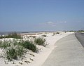 The beach between Johnson Bayou and Holly Beach prior to Hurricane Rita in 2005
 -
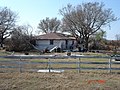 A house in Johnson Bayou destroyed by Hurricane Rita
 -
 Hurricane Ike damage to main store and buildings
 -
 Hurricane Ike damage to school building
 -
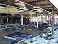 School suffered severe damage inside building due to Hurricane Ike
 -
 Church and buildings damaged by Hurricane Ike
 -
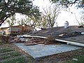 Brick house completely destroyed with nearby double wide house severely damaged from Hurricane Ike


See also edit
References edit
- Galveston Daily News, October 14–23, 1886.
- ^ Roth, David. "Louisiana Hurricane History: Late 19th century" – the National Weather Service at NOAA
- ^ Roth, David. "Texas Hurricane History: Late 19th century" – the National Weather Service at NOAA
- ^ Block, W. T. "October 12, 1886: The Night That Johnson's Bayou, Louisiana Died" – the Beaumont Enterprise – October 10, 1979
- ^ Block, W. T. "The Great Storm of 1886" – the Beaumont Enterprise – January 9, 1977
- ^ Block, W. T. "The Romance of Sabine Lake: 1777–1900" – Texas Gulf Historical Society – 1973
- ^ Young, Nancy Beck. "Sabine and East Texas Railway" – Handbook of Texas Online – (accessed September 14, 2007)
- ^ "Louisiana Library Directory." State Library of Louisiana. Accessed September 22, 2008.