


Summary
Junction Butte is a 6,400-foot-elevation (2,000-meter) summit located in the Island in the Sky District of Canyonlands National Park, in San Juan County, Utah.[3] It is set about one mile south of the southern tip of Island in the Sky. A short hike to Grand View Point provides a view of Junction Butte. Access to this butte is via the four-wheel drive White Rim Road, which is another option to view Junction Butte. Topographic relief is significant as the top of this geological formation rises 1,400 feet above the road in less than one mile. Precipitation runoff from Junction Butte drains east into the nearby Colorado River, and west into nearby Green River. Junction Butte is situated north of the junction of these two major rivers.
| Junction Butte | |
|---|---|
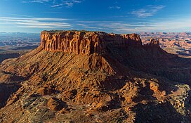 North aspect from Grand View Point | |
| Highest point | |
| Elevation | 6,400 ft (2,000 m)[1] |
| Prominence | 1,720 ft (520 m)[1] |
| Parent peak | Elaterite Butte (6,552 ft)[1] |
| Isolation | 10.16 mi (16.35 km)[2] |
| Coordinates | 38°17′11″N 109°52′23″W / 38.286513°N 109.873045°W[1] |
| Geography | |
 Junction Butte Location of Junction Butte in Utah  Junction Butte Junction Butte (the United States) | |
| Country | United States |
| State | Utah |
| County | San Juan |
| Protected area | Canyonlands National Park |
| Parent range | Colorado Plateau |
| Topo map | USGS Monument Basin |
| Geology | |
| Age of rock | Late Triassic |
| Type of rock | Wingate Sandstone |
| Climbing | |
| Easiest route | class 5.2 climbing[2] |
Geology edit
This feature is composed of hard, fine-grained Wingate Sandstone, which is the remains of wind-borne sand dunes deposited approximately 200 million years ago in the Late Triassic. This Wingate sandstone, capped by Kayenta Formation, forms steep cliffs as it overlays softer layers of the Chinle Formation.[4]

Climate edit
Spring and fall are the most favorable seasons to visit Junction Butte. According to the Köppen climate classification system, it is located in a Cold semi-arid climate zone, which is defined by the coldest month having an average mean temperature below −0 °C (32 °F) and at least 50% of the total annual precipitation being received during the spring and summer. This desert climate receives less than 10 inches (250 millimeters) of annual rainfall, and snowfall is generally light during the winter.
| Climate data for Island in the Sky Visitor Center, elevation 5,666 ft (1,727 m), 1981-2010 normals, extremes 1981-2019 | |||||||||||||
|---|---|---|---|---|---|---|---|---|---|---|---|---|---|
| Month | Jan | Feb | Mar | Apr | May | Jun | Jul | Aug | Sep | Oct | Nov | Dec | Year |
| Record high °F (°C) | 58.6 (14.8) |
69.0 (20.6) |
79.8 (26.6) |
86.1 (30.1) |
98.5 (36.9) |
103.9 (39.9) |
106.4 (41.3) |
101.1 (38.4) |
97.9 (36.6) |
86.9 (30.5) |
71.0 (21.7) |
59.2 (15.1) |
106.4 (41.3) |
| Mean daily maximum °F (°C) | 38.1 (3.4) |
44.1 (6.7) |
54.9 (12.7) |
63.5 (17.5) |
74.2 (23.4) |
85.4 (29.7) |
91.7 (33.2) |
88.7 (31.5) |
79.5 (26.4) |
65.8 (18.8) |
49.7 (9.8) |
38.1 (3.4) |
64.6 (18.1) |
| Mean daily minimum °F (°C) | 20.8 (−6.2) |
25.8 (−3.4) |
33.3 (0.7) |
40.0 (4.4) |
49.5 (9.7) |
59.8 (15.4) |
66.0 (18.9) |
63.9 (17.7) |
54.9 (12.7) |
42.5 (5.8) |
31.1 (−0.5) |
21.3 (−5.9) |
42.5 (5.8) |
| Record low °F (°C) | −8.0 (−22.2) |
−12.4 (−24.7) |
10.4 (−12.0) |
16.3 (−8.7) |
26.0 (−3.3) |
28.7 (−1.8) |
46.0 (7.8) |
50.2 (10.1) |
27.6 (−2.4) |
9.2 (−12.7) |
6.2 (−14.3) |
−9.4 (−23.0) |
−12.4 (−24.7) |
| Average precipitation inches (mm) | 0.53 (13) |
0.50 (13) |
0.76 (19) |
0.72 (18) |
0.70 (18) |
0.45 (11) |
0.93 (24) |
1.04 (26) |
1.06 (27) |
1.30 (33) |
0.70 (18) |
0.58 (15) |
9.27 (235) |
| Average dew point °F (°C) | 18.6 (−7.4) |
21.8 (−5.7) |
23.3 (−4.8) |
25.7 (−3.5) |
29.5 (−1.4) |
32.7 (0.4) |
41.2 (5.1) |
45.1 (7.3) |
37.6 (3.1) |
29.5 (−1.4) |
23.2 (−4.9) |
17.9 (−7.8) |
28.9 (−1.7) |
| Source: PRISM[5] | |||||||||||||
See also edit
References edit

- ^ a b c d "Junction Butte, Utah". Peakbagger.com. Retrieved 2020-11-01.
- ^ a b "Junction Butte - 6,400' UT". listsofjohn.com. Retrieved 2020-11-01.
- ^ "Junction Butte". Geographic Names Information System. United States Geological Survey, United States Department of the Interior. Retrieved 2020-11-01.
- ^ S.W. Lohman, The Geologic Story of Canyonlands National Park, US Government Printing Office, 1974, page 25.
- ^ "PRISM Climate Group, Oregon State University". Archived from the original on August 25, 2019. Retrieved February 19, 2019.
External links edit
- Canyonlands National Park National Park Service
- Junction Butte: weather forecast
- Junction Butte from Monument Basin (photo}: Flickr