


Summary
Kainga is a settlement on the southern bank of the Waimakariri River, just north of Christchurch, in Canterbury, New Zealand. It lies immediately to the south of Kaiapoi, on a small road leading northeast from State Highway 1.[3]
Kainga | |
|---|---|
 Fanfare sculpture | |
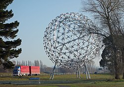
 | |
| Coordinates: 43°24′39″S 172°39′45″E / 43.41083°S 172.66250°E | |
| Country | New Zealand |
| Region | Canterbury |
| Territorial authority | Christchurch City |
| Ward |
|
| Community |
|
| Electorates | |
| Government | |
| • Territorial Authority | Christchurch City Council |
| • Regional council | Environment Canterbury |
| • Mayor of Christchurch | Phil Mauger |
| • Waimakariri MP/Christchurch East MP | Matthew Doocey/Reuben Davidson |
| • Te Tai Tonga MP | Tākuta Ferris |
| Area | |
| • Total | 2.37 km2 (0.92 sq mi) |
| Population (2018 Census)[2] | |
| • Total | 195 |
| • Density | 82/km2 (210/sq mi) |
Originally established as a small group of fishing huts on the south side of the Waimakariri, it later developed into a small residential area.[4] A small forestry plantation lies to the southeast of the settlement.[3]
Demographics edit
Kainga is in an SA1 statistical area which covers 2.37 km2 (0.92 sq mi).[1] The SA1 area is part of the larger Styx statistical area.[5]
| Year | Pop. | ±% p.a. |
|---|---|---|
| 2006 | 195 | — |
| 2013 | 201 | +0.43% |
| 2018 | 195 | −0.60% |
| Source: [2] | ||
The SA1 statistical area had a population of 195 at the 2018 New Zealand census, a decrease of 6 people (−3.0%) since the 2013 census, and unchanged since the 2006 census. There were 81 households, comprising 105 males and 93 females, giving a sex ratio of 1.13 males per female. The median age was 39.6 years (compared with 37.4 years nationally), with 36 people (18.5%) aged under 15 years, 33 (16.9%) aged 15 to 29, 105 (53.8%) aged 30 to 64, and 21 (10.8%) aged 65 or older.
Ethnicities were 93.8% European/Pākehā, 16.9% Māori, 3.1% Pasifika, 1.5% Asian, and 1.5% other ethnicities. People may identify with more than one ethnicity.
Although some people chose not to answer the census's question about religious affiliation, 75.4% had no religion, 16.9% were Christian, 1.5% had Māori religious beliefs and 1.5% had other religions.
Of those at least 15 years old, 15 (9.4%) people had a bachelor's or higher degree, and 48 (30.2%) people had no formal qualifications. The median income was $31,200, compared with $31,800 nationally. 15 people (9.4%) earned over $70,000 compared to 17.2% nationally. The employment status of those at least 15 was that 84 (52.8%) people were employed full-time, 24 (15.1%) were part-time, and 6 (3.8%) were unemployed.[2]
References edit
- ^ a b "ArcGIS Web Application". statsnz.maps.arcgis.com. Retrieved 7 September 2021.
- ^ a b c "Statistical area 1 dataset for 2018 Census". Statistics New Zealand. March 2020. 7024279.
- ^ a b Dowling, P. (ed.) (2004). ’’Reed New Zealand atlas’’. Auckland: Reed Publishing. ISBN 0 7900 0952 8. Map 82.
- ^ Wise's New Zealand guide (1969) Dunedin: H. Wise & Co., p. 110.
- ^ 2018 Census place summary: Styx