
KNOWPIA
WELCOME TO KNOWPIA

Kalat, Razavi Khorasan 
Summary
Kalat (Persian: كلات; also Romanized as Kalāt; also known as Kalūt)[3] is a city in the Central District of Kalat County, Razavi Khorasan province, Iran, serving as capital of both the county and the district.[4] Nader Shah governed the area after the fall of the Safavids.[5]
Kalat
Persian: كلات | |
|---|---|
City | |
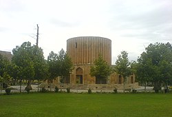 Sun Palace of the Afsharid dynasty | |
 Kalat | |
| Coordinates: 36°59′42″N 59°45′46″E / 36.99500°N 59.76278°E[1] | |
| Country | Iran |
| Province | Razavi Khorasan |
| County | Kalat |
| District | Central |
| Population (2016)[2] | |
| • Total | 7,687 |
| Time zone | UTC+3:30 (IRST) |
| • Summer (DST) | UTC+4:30 (IRDT) |
| Kalat, Razavi Khorasan at GEOnet Names Server | |
At the 2006 census, its population was 6,529 in 1,661 households.[6] The following census in 2011 counted 7,532 people in 1,933 households.[7] The latest census in 2016 showed a population of 7,687 people in 2,110 households.[2]
See also edit
- Kalat-i-nadiri, a massive natural fortress
- Reza Qoli Mirza Afshar
References edit
- ^ OpenStreetMap contributors (30 April 2023). "Kalat, Kalat County" (Map). OpenStreetMap. Retrieved 30 April 2023.
- ^ a b "Census of the Islamic Republic of Iran, 1395 (2016)". AMAR (in Persian). The Statistical Center of Iran. p. 09. Archived from the original (Excel) on 2 April 2022. Retrieved 19 December 2022.
- ^ Kalat, Razavi Khorasan can be found at GEOnet Names Server, at this link, by opening the Advanced Search box, entering "-3068804" in the "Unique Feature Id" form, and clicking on "Search Database".
- ^ Aref, Mohammad Reza (18 December 1381). "Letter of approval regarding divisional reforms in Khorasan province (Zavin District, Kalat County, Central District)". Laws and Regulations Portal of the Islamic Republic of Iran (in Persian). Ministry of Interior, Political-Defense Commission of the Cabinet of Ministers. Archived from the original on 7 January 2024. Retrieved 7 January 2024.
- ^ Axworthy, Michael (2009). The Sword of Persia: Nader Shah, from Tribal Warrior to Conquering Tyrant. I.B. Tauris. ISBN 978-1845119829.
- ^ "Census of the Islamic Republic of Iran, 1385 (2006)". AMAR (in Persian). The Statistical Center of Iran. p. 09. Archived from the original (Excel) on 20 September 2011. Retrieved 25 September 2022.
- ^ "Census of the Islamic Republic of Iran, 1390 (2011)". Syracuse University (in Persian). The Statistical Center of Iran. p. 09. Archived from the original (Excel) on 20 January 2023. Retrieved 19 December 2022.
- Tod, J. K. (1923) "Kalat-I-Nadiri", The Geographical Journal 62(5): pp. 366–370
External links edit
- Kalāt-e Nāderi, in Persian, Jadid Online, 2006, [1].
A Slide Show of Kalāt-e Nāderi by Shahāb Āzādeh, Jadid Online, 2006, [2] (2 min 30 sec). - Farshid Sāmāni, Konj-e Denj-e Fāteh-e Hend (The Quiet Corner of the Conqueror of India), in Persian, Jadid Online, 14 January 2010, [3].
• Audio slideshow: [4] (3 min 38 sec).