


Summary
Kaleybar County (Persian: شهرستان کلیبر) is in East Azerbaijan province, Iran. Its capital is the city of Kaleybar.[3]
Kaleybar County
Persian: شهرستان کلیبر | |
|---|---|
County | |
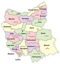 Location of Kaleybar County in East Azerbaijan province (top right, pink) | |
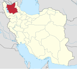 Location of East Azerbaijan province in Iran | |
| Coordinates: 38°56′N 47°06′E / 38.933°N 47.100°E[1] | |
| Country | |
| Province | East Azerbaijan |
| Capital | Kaleybar |
| Districts | Central, Abish Ahmad |
| Population (2016)[2] | |
| • Total | 46,125 |
| Time zone | UTC+3:30 (IRST) |
| Kaleybar County can be found at GEOnet Names Server, at this link, by opening the Advanced Search box, entering "9205876" in the "Unique Feature Id" form, and clicking on "Search Database". | |
At the 2006 census, the county's population was 87,259, in 19,250 households.[4] The following census in 2011 counted 48,837 people in 12,760 households,[5] by which time Khoda Afarin District had been separated from the county in the establishment of Khoda Afarin County.[6] At the 2016 census, the county's population was 46,125 in 14,145 households.[2]
In addition to the capital city, the county is noted for the Arasbaran forests protected area[7] and the Bazz Galasi, the fortress of Babak Khorramdin.[8]
Administrative divisions edit
The population history and structural changes of Kaleybar County's administrative divisions over three consecutive censuses are shown in the following table. The latest census shows two districts, seven rural districts, and two cities.[2]
| Administrative Divisions | 2006[4] | 2011[5] | 2016[2] |
|---|---|---|---|
| Central District | 27,676 | 26,652 | 24,297 |
| Misheh Pareh RD | 3,034 | 3,137 | 2,757 |
| Mulan RD | 5,785 | 4,897 | 4,001 |
| Peyghan Chayi RD | 5,981 | 5,848 | 5,452 |
| Yeylaq RD | 3,846 | 2,883 | 2,763 |
| Kaleybar (city) | 9,030 | 9,887 | 9,324 |
| Abish Ahmad District | 25,122 | 22,185 | 21,828 |
| Abish Ahmad RD | 11,989 | 11,585 | 11,531 |
| Qeshlaq RD | 6,468 | 5,250 | 4,933 |
| Seyyedan RD | 4,336 | 3,032 | 2,649 |
| Abish Ahmad (city) | 2,329 | 2,318 | 2,715 |
| Khoda Afarin District1 | 34,461 | ||
| Bastamlu RD | 5,907 | ||
| Dizmar-e Sharqi RD | 2,888 | ||
| Garamduz RD | 11,434 | ||
| Keyvan RD | 2,905 | ||
| Minjavan-e Gharbi RD | 4,378 | ||
| Minjavan-e Sharqi RD | 5,727 | ||
| Khomarlu (city) | 1,222 | ||
| Total | 87,259 | 48,837 | 46,125 |
| RD: Rural District 1Became a part of Khoda Afarin County[6] | |||
References edit
- ^ OpenStreetMap contributors (3 April 2023). "Kaleybar County" (Map). OpenStreetMap. Retrieved 3 April 2023.
- ^ a b c d "Census of the Islamic Republic of Iran, 1395 (2016)". AMAR (in Persian). The Statistical Center of Iran. p. 03. Archived from the original (Excel) on 13 November 2020. Retrieved 19 December 2022.
- ^ Habibi, Hassan (7 July 1369). "Approval of the organization and chain of citizenship of the elements and units of the country divisions of East Azerbaijan province centered on the city of Tabriz". Islamic Parliament Research Center (in Persian). Ministry of Interior, Defense Political Commission of the Government Board. Archived from the original on 4 August 2013. Retrieved 4 December 2023.
- ^ a b "Census of the Islamic Republic of Iran, 1385 (2006)". AMAR (in Persian). The Statistical Center of Iran. p. 03. Archived from the original (Excel) on 20 September 2011. Retrieved 25 September 2022.
- ^ a b "Census of the Islamic Republic of Iran, 1390 (2011)". Syracuse University (in Persian). The Statistical Center of Iran. p. 03. Archived from the original (Excel) on 16 January 2023. Retrieved 19 December 2022.
- ^ a b Rahimi, Mohammad Reza (7 September 1389). "Letter of approval regarding country divisions in Kaleybar County". Qavanin (in Persian). Ministry of Interior, Council of Ministers. Archived from the original on 26 September 2022. Retrieved 20 November 2023.
- ^ Adamec, Ludwig W. (1976) Historical Gazetteer of Iran: Tehran and Northwestern Iran Akademische Drucku. Verlagsanstalt, Graz, Austria, page 326, ISBN 3-201-00992-X
- ^ Burke, Andrew and Elliott. Mark (2008) Iran Lonely Planet, Footscray, Victoria, Australia, page 159, ISBN 978-1-74104-293-1