
KNOWPIA
WELCOME TO KNOWPIA

Kalumburu Road 
Summary
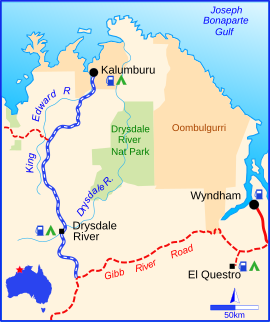
The Kalumburu Road in the Kimberley region of Western Australia is a 267 kilometre unsealed road that connects the Gibb River Road to the Aboriginal community of Kalumburu on the coast via the Mitchell Plateau.[1][2] The road, which often becomes inaccessible during the wet season,[3] is suitable for four-wheel drive traffic and facilities are limited to supplies available at the roadhouse at the Drysdale River Station.[4] Kalumburu Road runs north from the Gibb River Road, which it intersects approximately 250 km west of Kununurra.[5] It also provides visitors access to Mitchell Falls.
Kalumburu Road | |
|---|---|
 | |
| Kalumburu Road (blue and white) | |
| General information | |
| Type | Rural road |
| Length | 267 km (166 mi) |
| Major junctions | |
See also edit
![]() Australian Roads portal
Australian Roads portal
References edit
- ^ "Gibb River Road, Kalumburu & the Mitchell Plateau". Australia's Northwest. Retrieved 7 September 2008.
- ^ Hema, Maps (2007). Australia Road and 4WD Atlas (Map). Eight Mile Plains Queensland: Hema Maps. p. 89. ISBN 978-1-86500-456-3.
- ^ O'Byrne, Denis; Rob Van Driesum; Paul Harding; Pete Cruttenden; Mic Looby (1988). Lonely Planet Outback Australia. p. 321. ISBN 1-86450-187-1.
- ^ "The Gibb River Road". Open Road. NRMA. Archived from the original on 19 July 2008. Retrieved 7 September 2008.
- ^ Gebicki, Michael (14 May 2005). "Discovering Our Glorious Frontier". The Sun-Herald. The Age. Retrieved 7 September 2008.