
KNOWPIA
WELCOME TO KNOWPIA

Kamoenai, Hokkaido 
Summary
Kamoenai (神恵内村, Kamoenai-mura) is a village located in Shiribeshi Subprefecture, Hokkaido, Japan. It is the second smallest municipality in Hokkaido by population, after Otoineppu.
Kamoenai
神恵内村 | |
|---|---|
Village | |
 Kamoenai village office | |
 Flag  Emblem | |
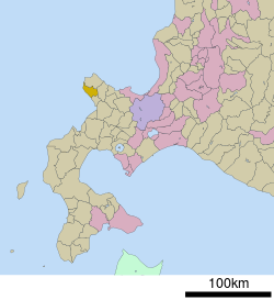 Location of Kamoenai in Hokkaido (Shiribeshi Subprefecture) | |
 Kamoenai Location in Japan | |
| Coordinates: 43°9′N 140°26′E / 43.150°N 140.433°E | |
| Country | Japan |
| Region | Hokkaido |
| Prefecture | Hokkaido (Shiribeshi Subprefecture) |
| District | Furuu |
| Government | |
| • Mayor | Masayuki Takahashi |
| Area | |
| • Total | 147.71 km2 (57.03 sq mi) |
| Population (September 30, 2016) | |
| • Total | 904 |
| • Density | 6.1/km2 (16/sq mi) |
| Time zone | UTC+09:00 (JST) |
| City hall address | 81-4 Kamoenaimura, Kamoenai, Furuu-gun, Hokkaido 045-0301 |
| Climate | Dfb |
| Website | www |
| Symbols | |
| Fish | Chum salmon |
| Mascot | Dragon-ta (どらごん太) and Tatsu-hime (たつ姫) |
| Tree | Abies sachalinensis |
As of September 2016, the village has an estimated population of 904. The total area is 147.71 km2.
Geography edit
Kamoenai is located on the western of the Shakotan Peninsula.
Neighboring towns and village edit
Climate edit
| Climate data for Kamoenai (1991−2020 normals, extremes 1977−present) | |||||||||||||
|---|---|---|---|---|---|---|---|---|---|---|---|---|---|
| Month | Jan | Feb | Mar | Apr | May | Jun | Jul | Aug | Sep | Oct | Nov | Dec | Year |
| Record high °C (°F) | 8.9 (48.0) |
12.2 (54.0) |
15.2 (59.4) |
22.7 (72.9) |
30.0 (86.0) |
29.1 (84.4) |
33.5 (92.3) |
33.1 (91.6) |
32.2 (90.0) |
24.8 (76.6) |
19.6 (67.3) |
15.0 (59.0) |
33.5 (92.3) |
| Mean daily maximum °C (°F) | 0.0 (32.0) |
0.5 (32.9) |
4.2 (39.6) |
10.0 (50.0) |
15.6 (60.1) |
19.6 (67.3) |
23.6 (74.5) |
25.4 (77.7) |
22.5 (72.5) |
16.1 (61.0) |
8.8 (47.8) |
2.3 (36.1) |
12.4 (54.3) |
| Daily mean °C (°F) | −2.3 (27.9) |
−1.9 (28.6) |
1.4 (34.5) |
6.7 (44.1) |
11.7 (53.1) |
15.7 (60.3) |
19.8 (67.6) |
21.4 (70.5) |
18.3 (64.9) |
12.5 (54.5) |
5.9 (42.6) |
−0.2 (31.6) |
9.1 (48.4) |
| Mean daily minimum °C (°F) | −4.7 (23.5) |
−4.4 (24.1) |
−1.3 (29.7) |
3.6 (38.5) |
8.3 (46.9) |
12.4 (54.3) |
16.9 (62.4) |
18.3 (64.9) |
14.7 (58.5) |
9.1 (48.4) |
2.9 (37.2) |
−2.8 (27.0) |
6.1 (42.9) |
| Record low °C (°F) | −13.0 (8.6) |
−13.8 (7.2) |
−9.6 (14.7) |
−3.1 (26.4) |
1.1 (34.0) |
5.0 (41.0) |
9.8 (49.6) |
12.0 (53.6) |
6.4 (43.5) |
0.2 (32.4) |
−8.3 (17.1) |
−12.2 (10.0) |
−13.8 (7.2) |
| Average precipitation mm (inches) | 94.8 (3.73) |
72.1 (2.84) |
59.8 (2.35) |
65.1 (2.56) |
88.0 (3.46) |
69.4 (2.73) |
140.3 (5.52) |
142.8 (5.62) |
153.8 (6.06) |
133.4 (5.25) |
122.1 (4.81) |
117.4 (4.62) |
1,257.6 (49.51) |
| Average precipitation days (≥ 1.0 mm) | 18.3 | 15.3 | 12.6 | 10.5 | 10.5 | 9.4 | 10.0 | 10.0 | 11.9 | 14.1 | 16.0 | 19.0 | 157.6 |
| Mean monthly sunshine hours | 42.4 | 58.8 | 123.5 | 173.7 | 198.1 | 171.5 | 157.6 | 166.5 | 169.6 | 129.0 | 65.8 | 35.5 | 1,487.5 |
| Source: Japan Meteorological Agency[1][2] | |||||||||||||
History edit
Kamoenai was developed by fisheries. Kamoenai Village was merged with Akaishi Village and Sannai Village and became a Second Class Village in 1906.
Education edit
- Kamoenai Elementary School
- Kamoenai Junior High School
References edit
External links edit
 Media related to Kamoenai, Hokkaidō at Wikimedia Commons
- Official Website (in Japanese)