


Summary
Kannami (函南町, Kannami-chō) is a town located in Tagata District, Shizuoka Prefecture, Japan. As of 1 August 2019[update], the town had an estimated population of 37,782 in 16,401 households [1] and a population density of 580 persons per km². The total area of the town was 65.16 square kilometres (25.16 sq mi).
Kannami
函南町 | |
|---|---|
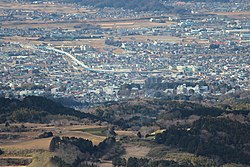 A view of downtown Kannami | |
 Flag  Emblem | |
 Location of Kannami in Shizuoka Prefecture | |
 Kannami | |
| Coordinates: 35°5′20.2″N 138°57′12.2″E / 35.088944°N 138.953389°E | |
| Country | Japan |
| Region | Chūbu Tōkai |
| Prefecture | Shizuoka |
| District | Tagata |
| Area | |
| • Total | 65.16 km2 (25.16 sq mi) |
| Population (July 31, 2019) | |
| • Total | 37,782 |
| • Density | 580/km2 (1,500/sq mi) |
| Time zone | UTC+9 (Japan Standard Time) |
| - Tree | Stewartia |
| - Flower | Sakura |
| Phone number | 055-979-8105 |
| Address | 717-13, Hirai, Kannnami-chō, Tagata-gun, Shizuoka-ken 419-0192 |
| Website | Official website |

Geography edit
Kannami is located in an inland area in far eastern Shizuoka Prefecture, and the "root" of the Izu Peninsula, and in the southern foothills of the Hakone Mountains and the Tanzawa Mountains. The Kano River passes through the town.
Neighboring municipalities edit
Demographics edit
Per Japanese census data,[2] the population of Kannami has been increasing over the past 50 years.
| Year | Pop. | ±% |
|---|---|---|
| 1940 | 10,625 | — |
| 1950 | 14,953 | +40.7% |
| 1960 | 15,505 | +3.7% |
| 1970 | 17,738 | +14.4% |
| 1980 | 28,749 | +62.1% |
| 1990 | 35,191 | +22.4% |
| 2000 | 38,611 | +9.7% |
| 2010 | 38,574 | −0.1% |
Climate edit
The city has a climate characterized by hot and humid summers, and relatively mild winters (Köppen climate classification Cfa). The average annual temperature in Kannami is 14.4 °C. The average annual rainfall is 1999 mm with September as the wettest month. The temperatures are highest on average in August, at around 25.2 °C, and lowest in January, at around 4.4 °C.[3]
History edit
During the Edo period, all of Izu Province was tenryō territory under direct control of the Tokugawa shogunate. During the cadastral reform of the early Meiji period in 1889, the village of Kannami was created within Tagata District, Shizuoka Prefecture. On April 1, 1962, it was elevated to town status.
Economy edit
The economy of Kannami is primarily based on agriculture. Major products include strawberries, cucumbers and dairy products. The town is also a bedroom community for neighboring Mishima.
Education edit
Kannami has five public elementary schools and two public middle schools operated by the town government. The town has one public high school operated by the Shizuoka Prefectural Board of Education.
Transportation edit
Railway edit
Highway edit
Sister city relations edit
 – Kerman, California, United States[4] – since October 12, 1985
Notable people from Kannami edit
- Atsuto Uchida – professional soccer player
References edit
- ^ Kannami Town official statistics (in Japanese)
- ^ Kannami population statistics
- ^ Kannami climate data
- ^ "International Exchange". List of Affiliation Partners within Prefectures. Council of Local Authorities for International Relations (CLAIR). Archived from the original on 13 January 2016. Retrieved 21 November 2015.
External links edit
- Kannami official website (Japanese)
![]() Media related to Kannami, Shizuoka at Wikimedia Commons
Media related to Kannami, Shizuoka at Wikimedia Commons