


Summary
Karpenisi (Greek: Καρπενήσι, Greek pronunciation: [karpeˈnisi]) is a town in central Greece. It is the capital of the regional unit of Evrytania. Karpenisi is situated in the valley of the river Karpenisiotis (Καρπενησιώτης), a tributary of the Megdovas, in the southern part of the Pindus Mountains. Mount Tymfristos (2,315 m elevation) lies directly to the north of the town, and the foothills of mount Kaliakouda are in the south. Karpenisi has a ski resort and is a popular destination, especially during winter. It is called Switzerland of Greece for the resemblance with the mountainous country and its beauty, atypical for a Mediterranean place.[3]
Karpenisi
Καρπενήσι | |
|---|---|
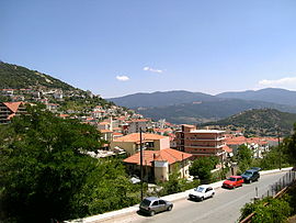 Part of the town | |
 Karpenisi Location within the region  | |
| Coordinates: 38°55′N 21°47′E / 38.917°N 21.783°E | |
| Country | Greece |
| Administrative region | Central Greece |
| Regional unit | Evrytania |
| Government | |
| • Mayor | Christos Kakavas[1] |
| Area | |
| • Municipality | 948.6 km2 (366.3 sq mi) |
| • Municipal unit | 250.9 km2 (96.9 sq mi) |
| Elevation | 960 m (3,150 ft) |
| Population (2021)[2] | |
| • Municipality | 11,445 |
| • Density | 12/km2 (31/sq mi) |
| • Municipal unit | 7,921 |
| • Municipal unit density | 32/km2 (82/sq mi) |
| • Community | 6,788 |
| Time zone | UTC+2 (EET) |
| • Summer (DST) | UTC+3 (EEST) |
| Postal code | 361 00 |
| Area code(s) | 22370 |
| Vehicle registration | ΚΗ |
| Website | www.karpenissi.gr |
Etymology edit
The name Karpenisi derives from the Aromanian word kárpinu[4] 'hornbeam' + the ending -iş. The Greek spelling Καρπενήσι is influenced by folk etymology, the second combining form appearing to be νησί 'island' (pronounced [niˈsi]). The first mention of the name is traced back to an Ottoman tax ledger of 1454–1455.[5]
Municipality edit


The municipality Karpenisi was formed at the 2011 local government reform by the merger of the following 6 former municipalities, that became municipal units:[6]
- Domnista (Ampliani, Domnista, Krikello, Mesokomi, Psiana, Roska, Stavloi)
- Fourna (Fourna, Kleisto, Vracha)
- Karpenisi (Agia Vlacherna, Agios Andreas, Agios Nikolaos, Fidakia, Kalesmeno, Karpenisi, Koryschades, Myriki, Papparousi, Pavlopoulo, Sella, Stefani, Stenoma, Voutyro)
- Ktimenia (Agia Triada, Agios Charalampos, Chochlia, Domianoi, Petralona)
- Potamia (Aniada, Chelidonas, Dermati, Karitsa, Klafsi, Megalo Chorio, Mikro Chorio, Mouzilo, Nostimo, Sygkrellos)
- Prousos (Alestia, Aspropyrgos, Esochoria, Kastania, Katavothra, Prodromos, Prousos, Sarkini, Stavrochori, Tornos, Velota)
The municipality has an area of 948.570 km2, the municipal unit 250.887 km2.[7]
Mayor of Karpenisi edit
- Kostas Bakoyannis, 2011–2014
- Nikos Souliotis, 2014–2023
- Christos Kakavas, since 2024
History edit
Karpenisi has a lot of history in the region. In antiquity, Karpenisi was known as Oechalia and ruled by king Evrytos, inventor of the bow.[8]
During the Greek Revolution of 1821, the towns mountainous location was of strategic importance for central Roumeli.[8] During more recent times, the region took part in WWI and WWII, becoming the place where the armed National Resistance was initiated.[8]
Climate edit
Due to its altitude, Karpenisi has a temperate climate (Köppen: C), with abundant rainfall year round and much cooler temperatures. Snowfall is frequent and heavy in winter, whereas summers are pleasantly warm with cool nights.
| Climate data for Karpenisi town weather station (998m) | |||||||||||||
|---|---|---|---|---|---|---|---|---|---|---|---|---|---|
| Month | Jan | Feb | Mar | Apr | May | Jun | Jul | Aug | Sep | Oct | Nov | Dec | Year |
| Mean daily maximum °C (°F) | 6 (43) |
8.9 (48.0) |
12.1 (53.8) |
14.4 (57.9) |
20.3 (68.5) |
24.5 (76.1) |
27.4 (81.3) |
28.5 (83.3) |
24.2 (75.6) |
19.9 (67.8) |
13 (55) |
10.5 (50.9) |
17.5 (63.4) |
| Mean daily minimum °C (°F) | −1.7 (28.9) |
0.2 (32.4) |
2.2 (36.0) |
4.4 (39.9) |
8.5 (47.3) |
12.7 (54.9) |
15.5 (59.9) |
16.4 (61.5) |
13.3 (55.9) |
9 (48) |
5.5 (41.9) |
2 (36) |
7.3 (45.2) |
| Average precipitation mm (inches) | 164.7 (6.48) |
108.7 (4.28) |
107.5 (4.23) |
101.2 (3.98) |
58.5 (2.30) |
54.8 (2.16) |
62.2 (2.45) |
39.7 (1.56) |
171.6 (6.76) |
76.7 (3.02) |
145 (5.7) |
179.7 (7.07) |
1,270.3 (49.99) |
| Source: http://penteli.meteo.gr/stations/karpenisitown/ (2019 - 2020 averages) | |||||||||||||
Historical population edit
| Year | Municipal unit | Municipality |
|---|---|---|
| 1981 | 5,230 | – |
| 1991 | 8,185 | – |
| 2001 | 9,390 | – |
| 2011 | 8,575 | 13,105 |
| 2021 | 7,921 | 11,445 |
Sister cities edit
 Asheville, United States[9]
 Messolonghi, Greece[10]
 Engomi, Cyprus[11]
Notable people edit
- Zacharias Papantoniou (1877–1940), writer
- Ioannis Theodoropoulos, bronze medal in the pole vault 1896 Summer Olympics
- Georgios Kondylis (1878–1936), General of the Greek army and Prime Minister of Greece
- Charalambos Katsimitros (1886–1962), General of the Greek army who distinguished himself during the Greco-Italian War
- Pavlos Bakoyannis (1935–1989), Greek politician and journalist
Notable events edit
- Battle of Karpenisi (8 August 1823) during the Greek War of Independence
References edit
- ^ "Municipality of Karpenissi: Municipal elections – October 2023". ekloges.ypes.gr. 9 October 2023.
- ^ "Αποτελέσματα Απογραφής Πληθυσμού - Κατοικιών 2021, Μόνιμος Πληθυσμός κατά οικισμό" [Results of the 2021 Population - Housing Census, Permanent population by settlement] (in Greek). Hellenic Statistical Authority. 29 March 2024.
- ^ Dana Facaros; Linda Theodorou (2003). Greece. New Holland Publishers. p. 382. ISBN 978-1-86011-898-2.
- ^ Oikonomou Konstantinos, Zagori toponym, Doctoral thesis, Ioannina 1986, pp. 752–753.
- ^ Beldiceanu, Nicoară; Vasiliu Năsturel, Petre Ștefan (1991). "Η Θεσσαλία στην περίοδο 1454/55–1506". ΘΕΣΣΑΛΙΚΟ ΗΜΕΡΟΛΟΓΙΟ (in Greek). 19: 105–106.
- ^ "ΦΕΚ B 1292/2010, Kallikratis reform municipalities" (in Greek). Government Gazette.
- ^ "Population & housing census 2001 (incl. area and average elevation)" (PDF) (in Greek). National Statistical Service of Greece. Archived from the original (PDF) on 21 September 2015.
- ^ a b c "History - municipality of Karpenisi". Karpenisi. Retrieved 7 March 2022.
- ^ "Karpenisi, Greece". Archived from the original on 25 July 2011. Retrieved 7 October 2010.
- ^ "Σε μια συγκινητική τελετή στην πλατεία Μάρκου Μπότσαρη αδελφοποιήθηκαν οι Δήμοι Ι.Π. Μεσολογγίου και Καρπενησίου". 8 August 2022.
- ^ "Διδυμοποιήσεις".
External links edit
- Tourist Guide of Karpenisi