


Summary
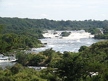
Karuma Falls is a town in Western Region of Uganda.
Karuma Falls | |
|---|---|
 Karuma Falls Map of Uganda showing the location of Karuma Falls. | |
| Coordinates: 02°14′03″N 32°14′47″E / 2.23417°N 32.24639°E | |
| Country | Uganda |
| Region | Western Region |
| Sub-region | Bunyoro sub-region |
| District | Kiryandongo District |
| Elevation | 1,000 m (3,000 ft) |
| Time zone | UTC+3 (EAT) |
Location edit
Karuma Falls is on the Kampala–Gulu Highway, immediately south of where the highway crosses the River Nile. Karuma Falls is approximately 97 kilometres (60 mi), by road, northeast of Masindi[1] and approximately 77 kilometres (48 mi), by road, south of Gulu, the largest city in Northern Uganda.[2]
Karuma Falls is the location of Karuma Power Station, the largest hydropower project in Uganda with a planned capacity of 600 megawatts.[3] The coordinates of Karuma Falls are 2° 14' 3.00"N, 32° 14' 47.00"E (latitude: 2.234167; longitude: 32.246390).[4] The average elevation is about 1,000 metres (3,300 ft) above sea level.[5]
Planning edit
In March 2013, Ugandan print media reported that the national government was planning a large modern city to be constructed at the site of the current town, to include the site of the proposed Karuma Power Station currently under construction.[6]
Points of interest edit
The following additional points of interest are found at or near Karuma Falls:
- Kampala–Gulu Highway, crossing the river at this location.
Photos and diagrams edit
- Photo of Karuma Falls at Gorillatales.com
See also edit
References edit
- ^ GFC (7 January 2016). "Distance between Masindi, Western Region, Uganda and Karuma Falls, Kiryandongo, Western Region, Uganda". Globefeed.com. Retrieved 7 January 2016.
- ^ GFC (7 January 2016). "Distance between Gulu, Northern Region, Uganda and Karuma Falls, Kiryandongo, Western Region, Uganda". Globefeed.com. Retrieved 7 January 2016.
- ^ Vision Reporter (1 December 2011). "Rural Areas Say Bye To Darkness: UETCL 10th Anniversary Supplement". New Vision. Kampala. Retrieved 3 July 2015.
- ^ Google (3 July 2015). "Location of Karuma Falls At Google Maps" (Map). Google Maps. Google. Retrieved 3 July 2015.
- ^ GAM (7 January 2016). "Elevation of Karuma Falls, Uganda". Getamap.net (GAM). Retrieved 7 January 2016.
- ^ Tabu Butagira, and Abdu Kiyaga (31 March 2013). "Government Plans To Build New City At Karuma". Daily Monitor. Kampala.
External links edit
- Karuma Falls Dam Project
- Potential Hydropower Projects in Uganda[permanent dead link]