


Summary
The Kaskawulsh Glacier is a vast, temperate valley glacier nestled in the St. Elias Mountains, within Kluane National Park in the Canadian territory of Yukon.[1]
| Kaskawulsh Glacier | |
|---|---|
 Kaskawulsh Glacier junction from the air, August 2004 | |
 Yukon | |
| Type | Valley glacier |
| Location | Canada |
| Coordinates | 60°48′N 138°36′W / 60.800°N 138.600°W |
| Length | 78 kilometers (48 mi) |
| Terminus | sealevel |
| Status | retreating |
Geography edit
Located approximately 6,000–9,000 ft (1,800–2,700 m) above sea level, the glacier covers more than 15,000 sq mi (39,000 km2) of the surrounding landscape.[2] It terminates at the head of two river valleys, the Slims and the Kaskawulsh River, which feed the Yukon River (via Kluane Lake) and Alsek River systems respectively.[3] The Kaskawulsh is the result of two converging outlet glaciers, the Central and North Arms, and is an impressive 3–4 mi (4.8–6.4 km) wide at its broadest point.[2]
Waterflow edit
Until 2016, abundant melt water from the Kaskawulsh was channeled by ice dam to drain through the Slims River, north to Kluane Lake, and ultimately to the Bering Sea. In 2016, as the glacier receded, the predominant flow abruptly switched to the Kaskawulsh River, flowing east and then south to Alsek River and to the Gulf of Alaska.[4][5] As the water level at Kluane Lake continues to drop, researchers expect this will become an isolated lake cut off from any outflow.[6]
Tourism edit
Backpackers can visit the Kaskawulsh along the popular Slims River West Trail, which follows the Slims River south for 19.9 mi (32.0 km) before ending at the summit of Observation Mountain near the toe of the glacier.[7][8][9] Backpackers can also follow the Slims River East Route to reach the toe of the glacier, also known as the glacier terminus.
-
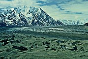 Terminus of the Kaskawulsh Glacier
 -
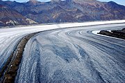 Kaskawulsh Glacier medial moraine. August 2013
 -
 Kaskawulsh Glacier seen from Mount Weyprecht. August 2013


References edit
- ^ Norah Foy; Luke Copland; Christian Zdanowicz; Mike Demuth; Chris Hopkinson (7 July 2011). "Recent volume and area changes of Kaskawulsh Glacier, Yukon, Canada" (PDF). Journal of Glaciology. 57 (203): 515–525. Bibcode:2011JGlac..57..515F. doi:10.3189/002214311796905596. Retrieved 2016-01-17.
- ^ a b "Kaskawulsh Glacier - Canadian Glacier Inventory Project". cgip.wikifoundry.com. Retrieved 2016-01-17.
- ^ Garry K. C. Clarke; Gerald Holdsworth (27 November 2002). "Glaciers of North America — Glaciers of Canada: Glaciers of the St. Elias Mountains" (PDF). U.S. Geological Survey Professional Paper 1386–J–1. Retrieved 2016-01-17.
- ^ Devlin, Hannah (17 April 2017). "Receding glacier causes immense Canadian river to vanish in four days". The Guardian. Retrieved 24 April 2017.
- ^ Shugar, Daniel H.; Clague, John J.; Best, James L.; Schoof, Christian; Willis, Michael J.; Copland, Luke; Roe, Gerard H. (2017-04-17). "River piracy and drainage basin reorganization led by climate-driven glacier retreat". Nature Geoscience. advance online publication (5): 370–375. doi:10.1038/ngeo2932. ISSN 1752-0908.
- ^ "Retreating Yukon glacier caused a river to disappear". Retrieved 2017-04-17.
- ^ "Slims River West trail to Observation Mountain, Kluane National Park". philarmitage.net. Retrieved 2016-01-17.
- ^ "Slims River West | Yukon, Canada, 1998 | The Hiking Life". thehikinglife.com. Retrieved 2016-01-17.
- ^ "Slim's River West | Hiking, skiing, and snowshoeing trails in the Yukon | yukonhiking.ca". yukonhiking.ca. Retrieved 2016-01-17.