


Summary
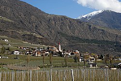
Kastelbell-Tschars (German: [ˌkastl̩ˈbɛl ˈtʃaːɐ̯s]; Italian: Castelbello-Ciardes [kaˌstɛlˈbɛllo ˈtʃardes]) is a comune (municipality) in South Tyrol in northern Italy, located about 40 kilometres (25 mi) northwest of Bolzano.
Kastelbell-Tschars | |
|---|---|
| Gemeinde Kastelbell-Tschars Comune di Castelbello-Ciardes | |
 | |
 Coat of arms | |
Location of Kastelbell-Tschars .mw-parser-output .locmap .od{position:absolute}.mw-parser-output .locmap .id{position:absolute;line-height:0}.mw-parser-output .locmap .l0{font-size:0;position:absolute}.mw-parser-output .locmap .pv{line-height:110%;position:absolute;text-align:center}.mw-parser-output .locmap .pl{line-height:110%;position:absolute;top:-0.75em;text-align:right}.mw-parser-output .locmap .pr{line-height:110%;position:absolute;top:-0.75em;text-align:left}.mw-parser-output .locmap .pv>div{display:inline;padding:1px}.mw-parser-output .locmap .pl>div{display:inline;padding:1px;float:right}.mw-parser-output .locmap .pr>div{display:inline;padding:1px;float:left}html.skin-theme-clientpref-night .mw-parser-output .od,html.skin-theme-clientpref-night .mw-parser-output .od .pv>div,html.skin-theme-clientpref-night .mw-parser-output .od .pl>div,html.skin-theme-clientpref-night .mw-parser-output .od .pr>div{background:#000;color:#fff}html.skin-theme-clientpref-night .mw-parser-output .locmap{filter:grayscale(0.6)}@media(prefers-color-scheme:dark){html.skin-theme-clientpref-os .mw-parser-output .locmap{filter:grayscale(0.6)}html.skin-theme-clientpref-os .mw-parser-output .od,html.skin-theme-clientpref-os .mw-parser-output .od .pv>div,html.skin-theme-clientpref-os .mw-parser-output .od .pl>div,html.skin-theme-clientpref-os .mw-parser-output .od .pr>div{background:#000;color:#fff}}  Kastelbell-Tschars Location of Kastelbell-Tschars in Italy  Kastelbell-Tschars Kastelbell-Tschars (Trentino-Alto Adige/Südtirol) | |
| Coordinates: 46°38′N 10°54′E / 46.633°N 10.900°E | |
| Country | Italy |
| Region | Trentino-Alto Adige/Südtirol |
| Province | South Tyrol (BZ) |
| Frazioni | Kastelbell (Castelbello), Tschars (Ciardes), Freiberg (Montefranco), Galsaun (Colsano), Juval (Juvale), Latschinig (Lacinigo), Tomberg (Montefontana), Trumsberg (Montetrumes) |
| Government | |
| • Mayor | Gustav Tappeiner |
| Area | |
| • Total | 53.9 km2 (20.8 sq mi) |
| Population (Nov. 2010)[2] | |
| • Total | 2,387 |
| • Density | 44/km2 (110/sq mi) |
| Demonym(s) | German:Kastelbeller or Tscharscher Italian: castelbellesi |
| Time zone | UTC+1 (CET) |
| • Summer (DST) | UTC+2 (CEST) |
| Postal code | 39020 |
| Dialing code | 0473 |
| Website | Official website |
Geography edit
As of 30 November 2010, it had a population of 2,387 and an area of 53.9 square kilometres (20.8 sq mi).[3]
Kastelbell-Tschars borders the following municipalities: Latsch, Naturns, Schnals and Ulten.
History edit
Coat-of-arms edit
The emblem is a gules mill wheel, with eight paddles, on argent background. It retakes the insignia of Counts Hendl owners of the castle from 1531 to 1949.[4]
Society edit
Linguistic distribution edit
According to the 2011 census, 98.72% of the population speak German and 1.28% Italian as first language.[5]
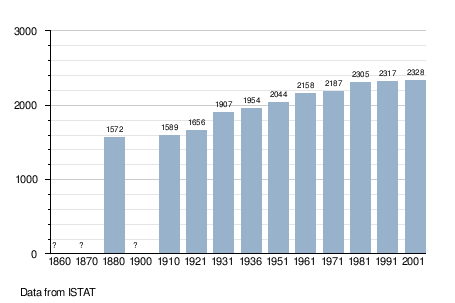
Demographic evolution edit
References edit
- ^ "Superficie di Comuni Province e Regioni italiane al 9 ottobre 2011". Italian National Institute of Statistics. Retrieved 16 March 2019.
- ^ "Popolazione Residente al 1° Gennaio 2018". Italian National Institute of Statistics. Retrieved 16 March 2019.
- ^ All demographics and other statistics: Italian statistical institute Istat.
- ^ Heraldry of the World: Kastelbell-Tschars
- ^ "Volkszählung 2011/Censimento della popolazione 2011". astat info (38). Provincial Statistics Institute of the Autonomous Province of South Tyrol: 6–7. June 2012. Retrieved 2012-06-14.
External links edit
- (in German and Italian) Homepage of the municipality
![]() Media related to Kastelbell-Tschars at Wikimedia Commons
Media related to Kastelbell-Tschars at Wikimedia Commons