


Summary
Kathua is a city and municipal council of the Jammu division of Indian-administered Jammu and Kashmir in the disputed Kashmir region.[1] The city is the headquarters of Kathua district and is divided into 27 wards which constitute the Kathua Municipal Council. It is situated along NH-44 The city has a bustling industrial area and an army cantonment adjoining it. Being a transit hub for industrial activity in the state, the city has a large industrial base with textile park, Biotechnology and Pharma industrial and research park, Cement industry and many medium scale MSMEs.[4][5][6][7]
Kathua | |
|---|---|
City administered by India | |
    Clockwise from top: Atal Setu, Jasrota Fort, Industrial Estate Atal Setu, Purthu Artificial Beach and Jasrota Fort in Kathua (J&K) | |
Interactive map of Kathua![Kathua lies in the Jammu division (neon blue) of the Indian-administered Jammu and Kashmir (shaded in tan) in the disputed Kashmir region.[1]](http://upload.wikimedia.org/wikipedia/commons/thumb/6/6e/Kashmir_region._LOC_2003626427_-_showing_Jammu_division_administered_by_India_in_neon_blue.jpg/250px-Kashmir_region._LOC_2003626427_-_showing_Jammu_division_administered_by_India_in_neon_blue.jpg) Kathua lies in the Jammu division (neon blue) of the Indian-administered Jammu and Kashmir (shaded in tan) in the disputed Kashmir region.[1] | |
| Coordinates: 32°23′06″N 75°31′01″E / 32.385°N 75.517°E | |
| Administering country | India |
| Union territory | Jammu and Kashmir |
| District | Kathua |
| Settled | 1025 BC[2] |
| Named for | "KATHAI"[3] |
| Government | |
| • Type | Municipal Council |
| • Body | Kathua Municipal Council (21) Seats |
| • Chairman Municipal Council | Naresh Sharma (BJP) |
| Area | |
| • Total | 28.32 km2 (10.93 sq mi) |
| Elevation | 393 m (1,289 ft) |
| Population (2011) | |
| • Total | 59,866 |
| • Density | 3,765/km2 (9,750/sq mi) |
| Languages = Dogri & Hindi | |
| Time zone | UTC+5:30 (IST) |
| PIN | 184101(HEAD OFFICE), 184104(Mini Secretariat) |
| Telephone code | 01922 |
| Literacy | 86.46% |
| Website | http://kathua.nic.in/ |
| [4][5][6][7] | |
Geography edit
Kathua is located at 32°22′N 75°31′E / 32.37°N 75.52°E. It has an average elevation of 393 metres (1,289 ft). The city is surrounded by three rivers. Ravi is 7 km (4.3 mi) down Kathua while Ujjh is about 11 km (6.8 mi) ahead on Jammu Highway. Kathua itself is situated along the banks of a khad which has been heavily polluted and encroached over there years and this has become a drain of sewage, dividing it into two boroughs: Parliwand, meaning the other side; and Orliwand, meaning this side. Itself being a Plain the area is surrounded in the North by snow-capped Sivalik hills. The large Ranjit Sagar Lake is 25 kms away and has a cooling effect on its climate. Kathua lies 88 kilometres south of Jammu.[8]
Demographics edit
Population edit
- Total population of the Municipal Council and Outgrowth areas is 59,688 with 31,717 males and 28,149 females. The sex ratio is 888 women per 1000 men. There are 12,061 households in the Municipal Council and Outgrowth areas.[4][5][6]
Literacy edit
- There are 46359 literates and 13,507 illiterates in the Municipal Council and Outgrowth areas resulting in an 86.46% literacy rate. The male and female literacy stand at 90.7% (25,605 indv.) and 81.75% (20,754) respectively.[4][5][6]
Language edit
Use of Urdu is predominant in official government documents along with English, but Dogri is the mother tongue and the vernacular language of the populace along with Hindi.
Religion edit
Hinduism is the largest religion in Kathua, followed by over 91% of the people. Sikhism is the second-largest religion with 4.75% adherents. Christianity and Islam form 1.09% and 2.68% of the population respectively.[9]
Climate edit
Kathua has a monsoon-influenced humid subtropical climate (Koppen Cwa). Kathua generally experiences extreme rainfall during the monsoon being on the windward side of Sivalik. Because of its proximity to rivers, the climate is moderate to very hot in summers and mild to very cold in winters. Summers are hot and the temperature may reach 37 degrees, while in winters, the temperature can dip to below 0 degrees at nights.
Heavy downpour is experienced during the monsoon season in July and August. The annual rainfall is around 1,700 millimetres (67 in), mainly in monsoons and winters. Heavy hailstorms may be experienced in February and March, but are very rare; Kathua does not experience snowfall. Fog and sometimes Smog occur regularly during the winters, especially in January and February.
Compared with Jammu, temperatures in Kathua remain fairly lower by 3-4 degrees. December and January can be very cold especially nights, while February to April and October- November remain pleasant and dry. August is generally humid and sometimes very uncomfortable. Winters are also wet due to frequent rains due to western disturbances. Late night thunderstorms are common while May is notorious for heavy dust storms.
| Climate data for Kathua (1983–2010) | |||||||||||||
|---|---|---|---|---|---|---|---|---|---|---|---|---|---|
| Month | Jan | Feb | Mar | Apr | May | Jun | Jul | Aug | Sep | Oct | Nov | Dec | Year |
| Record high °C (°F) | 30.4 (86.7) |
28.6 (83.5) |
36.8 (98.2) |
43.6 (110.5) |
44.8 (112.6) |
48.0 (118.4) |
42.5 (108.5) |
39.0 (102.2) |
38.8 (101.8) |
39.6 (103.3) |
32.2 (90.0) |
28.5 (83.3) |
48.0 (118.4) |
| Mean maximum °C (°F) | 23.7 (74.7) |
26.0 (78.8) |
31.6 (88.9) |
36.1 (97.0) |
37.0 (98.6) |
36.1 (97.0) |
36.3 (97.3) |
35.9 (96.6) |
35.2 (95.4) |
29.1 (84.4) |
30.0 (86.0) |
25.3 (77.5) |
36.3 (97.3) |
| Mean daily maximum °C (°F) | 18.1 (64.6) |
21.6 (70.9) |
26.5 (79.7) |
31.1 (88.0) |
34.1 (93.4) |
35.3 (95.5) |
32.1 (89.8) |
29.2 (84.6) |
30.8 (87.4) |
30.5 (86.9) |
26.5 (79.7) |
21.0 (69.8) |
28.1 (82.5) |
| Mean daily minimum °C (°F) | 2.5 (36.5) |
7.1 (44.8) |
13.0 (55.4) |
17.9 (64.2) |
22.6 (72.7) |
24.6 (76.3) |
24.1 (75.4) |
23.8 (74.8) |
22.1 (71.8) |
16.6 (61.9) |
11.3 (52.3) |
3.7 (38.7) |
15.8 (60.4) |
| Mean minimum °C (°F) | 2.3 (36.1) |
4.7 (40.5) |
8.5 (47.3) |
12.1 (53.8) |
17.5 (63.5) |
20.4 (68.7) |
20.6 (69.1) |
20.6 (69.1) |
18.1 (64.6) |
12.5 (54.5) |
7.5 (45.5) |
3.1 (37.6) |
2.3 (36.1) |
| Record low °C (°F) | −1.8 (28.8) |
0.2 (32.4) |
5.6 (42.1) |
9.2 (48.6) |
14.4 (57.9) |
17.6 (63.7) |
14.0 (57.2) |
14.0 (57.2) |
11.5 (52.7) |
7.4 (45.3) |
3.6 (38.5) |
0.0 (32.0) |
−1.8 (28.8) |
| Average rainfall mm (inches) | 69.3 (2.73) |
73.2 (2.88) |
43.3 (1.70) |
35.4 (1.39) |
34.0 (1.34) |
114.7 (4.52) |
429.4 (16.91) |
725.9 (28.58) |
127.2 (5.01) |
26.9 (1.06) |
18.4 (0.72) |
81.0 (3.19) |
1,778.7 (70.03) |
| Average rainy days | 3.2 | 3.8 | 3.5 | 2.5 | 3.1 | 6.4 | 12.7 | 11.9 | 6.2 | 1.4 | 1.0 | 1.8 | 57.2 |
| Average relative humidity (%) | 86 | 80 | 72 | 56 | 47 | 61 | 83 | 87 | 83 | 75 | 80 | 86 | 75 |
| Source: India Meteorological Department[10] | |||||||||||||
Tourist attractions edit

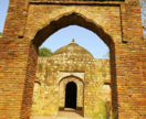
[11] Kathua has also many small canals flowing throughout the town.[12] In addition to gardens and canals, the district of Kathua also contains historical landmarks such as Jasrota Fort, Jasmergarh Fort and Bhadu Fort.
Transport edit
Kathua is 80 km (50 mi) away from Jammu city and 120 km (75 mi) from Katra. Interstate and Intrastate road transport is easily accessible due to the close proximity to NH44. Jammu Airport is the nearest major airport with regular flights. The town is connected by Indian railways to all major cities of India. Intra-district transport is also easily available for travelling within the town and surrounding areas.
Gallery edit
-
 Atal Setu bridge on Ravi river
 -
 Dream park and canal
 -
 Dream park
 -
 K.K. Birla Garden, Kathua


See also edit
References edit
- ^ a b The application of the term "administered" to the various regions of Kashmir and a mention of the Kashmir dispute is supported by the tertiary sources (a) through (d), reflecting due weight in the coverage. Although "controlled" and "held" are also applied neutrally to the names of the disputants or to the regions administered by them, as evidenced in sources (f) through (h) below, "held" is also considered politicized usage, as is the term "occupied," (see (i) below).
(a) Kashmir, region Indian subcontinent, Encyclopaedia Britannica, retrieved 15 August 2019 (subscription required) Quote: "Kashmir, region of the northwestern Indian subcontinent ... has been the subject of dispute between India and Pakistan since the partition of the Indian subcontinent in 1947. The northern and western portions are administered by Pakistan and comprise three areas: Azad Kashmir, Gilgit, and Baltistan, the last two being part of a territory called the Northern Areas. Administered by India are the southern and southeastern portions, which constitute the state of Jammu and Kashmir but are slated to be split into two union territories.";
(b) Pletcher, Kenneth, Aksai Chin, Plateau Region, Asia, Encyclopaedia Britannica, retrieved 16 August 2019 (subscription required) Quote: "Aksai Chin, Chinese (Pinyin) Aksayqin, portion of the Kashmir region, at the northernmost extent of the Indian subcontinent in south-central Asia. It constitutes nearly all the territory of the Chinese-administered sector of Kashmir that is claimed by India to be part of the Ladakh area of Jammu and Kashmir state.";
(c) "Kashmir", Encyclopedia Americana, Scholastic Library Publishing, 2006, p. 328, ISBN 978-0-7172-0139-6 C. E Bosworth, University of Manchester Quote: "KASHMIR, kash'mer, the northernmost region of the Indian subcontinent, administered partlv by India, partly by Pakistan, and partly by China. The region has been the subject of a bitter dispute between India and Pakistan since they became independent in 1947";
(d) Osmańczyk, Edmund Jan (2003), Encyclopedia of the United Nations and International Agreements: G to M, Taylor & Francis, pp. 1191–, ISBN 978-0-415-93922-5 Quote: "Jammu and Kashmir: Territory in northwestern India, subject to a dispute betw een India and Pakistan. It has borders with Pakistan and China."
(e) Talbot, Ian (2016), A History of Modern South Asia: Politics, States, Diasporas, Yale University Press, pp. 28–29, ISBN 978-0-300-19694-8 Quote: "We move from a disputed international border to a dotted line on the map that represents a military border not recognized in international law. The line of control separates the Indian and Pakistani administered areas of the former Princely State of Jammu and Kashmir.";
(f) Kashmir, region Indian subcontinent, Encyclopaedia Britannica, retrieved 15 August 2019 (subscription required) Quote: "... China became active in the eastern area of Kashmir in the 1950s and has controlled the northeastern part of Ladakh (the easternmost portion of the region) since 1962.";
(g) Bose, Sumantra (2009), Kashmir: Roots of Conflict, Paths to Peace, Harvard University Press, pp. 294, 291, 293, ISBN 978-0-674-02855-5 Quote: "J&K: Jammu and Kashmir. The former princely state that is the subject of the Kashmir dispute. Besides IJK (Indian-controlled Jammu and Kashmir. The larger and more populous part of the former princely state. It has a population of slightly over 10 million, and comprises three regions: Kashmir Valley, Jammu, and Ladakh.) and AJK ('Azad" (Free) Jammu and Kashmir. The more populous part of Pakistani-controlled J&K, with a population of approximately 2.5 million. AJK has six districts: Muzaffarabad, Mirpur, Bagh, Kodi, Rawalakot, and Poonch. Its capital is the town of Muzaffarabad. AJK has its own institutions, but its political life is heavily controlled by Pakistani authorities, especially the military), it includes the sparsely populated "Northern Areas" of Gilgit and Baltistan, remote mountainous regions which are directly administered, unlike AJK, by the Pakistani central authorities, and some high-altitude uninhabitable tracts under Chinese control."
(h) Fisher, Michael H. (2018), An Environmental History of India: From Earliest Times to the Twenty-First Century, Cambridge University Press, p. 166, ISBN 978-1-107-11162-2 Quote: "Kashmir’s identity remains hotly disputed with a UN-supervised “Line of Control” still separating Pakistani-held Azad (“Free”) Kashmir from Indian-held Kashmir.";
(i) Snedden, Christopher (2015), Understanding Kashmir and Kashmiris, Oxford University Press, p. 10, ISBN 978-1-84904-621-3 Quote:"Some politicised terms also are used to describe parts of J&K. These terms include the words 'occupied' and 'held'." - ^ "Introduction of Kathua, History of Kathua". jkonline.in. Retrieved 6 March 2024.
- ^ "History | District Kathua, Government of Jammu & Kashmir | India".
- ^ a b c d Directorate of Census Operations, Jammu and Kashmir (n.d.). District Census Handbook Kathua (Part-A) (PDF) (Report). pp. 8–17, 33–40, 44–47, 55, 56, 287, 296.
- ^ a b c d Directorate of Census Operations, Jammu and Kashmir (n.d.). District Census Handbook Kathua (Part-B) (PDF) (Report). pp. 7–14, 28–29, 36–39.
- ^ a b c d "District Kathua, Jammu & Kashmir".
- ^ a b "Housing and Urban Development Department, Government of Jammu & Kashmir". jkhudd.gov.in. Retrieved 14 May 2020.
- ^ Falling Rain Genomics, Inc - Kathua
- ^ a b "Kathua City Population". Census India. Retrieved 27 September 2020.[permanent dead link]
- ^ "1981-2010 Climatological Normals, Climatological Tables of Observatories in India 1981–2010" (PDF). India Meteorological Department. pp. 399–400. Retrieved 27 February 2021.
- ^ "Tourist Places | District Kathua, Government of Jammu & Kashmir | India".
- ^ "Kathua Tourism, Travel Guide & Tourist Places in Kathua-NativePlanet".
External links edit
- History of Kathua
- Official website of District Kathua (J&K)
- mykathua.com - A web portal about kathua