
KNOWPIA
WELCOME TO KNOWPIA

Katrenikona 
Summary
Katrenikona is a village in Dr. B.R. Ambedkar Konaseema district of the Indian state of Andhra Pradesh. It is located in Katrenikona Mandal of Amalapuram revenue division of the district.[1][3]
Katrenikona | |
|---|---|
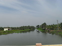 Godavari canal near Katrenikona | |
Dynamic map.mw-parser-output .locmap .od{position:absolute}.mw-parser-output .locmap .id{position:absolute;line-height:0}.mw-parser-output .locmap .l0{font-size:0;position:absolute}.mw-parser-output .locmap .pv{line-height:110%;position:absolute;text-align:center}.mw-parser-output .locmap .pl{line-height:110%;position:absolute;top:-0.75em;text-align:right}.mw-parser-output .locmap .pr{line-height:110%;position:absolute;top:-0.75em;text-align:left}.mw-parser-output .locmap .pv>div{display:inline;padding:1px}.mw-parser-output .locmap .pl>div{display:inline;padding:1px;float:right}.mw-parser-output .locmap .pr>div{display:inline;padding:1px;float:left}html.skin-theme-clientpref-night .mw-parser-output .od,html.skin-theme-clientpref-night .mw-parser-output .od .pv>div,html.skin-theme-clientpref-night .mw-parser-output .od .pl>div,html.skin-theme-clientpref-night .mw-parser-output .od .pr>div{background:#fff;color:#000}html.skin-theme-clientpref-night .mw-parser-output .locmap{filter:grayscale(0.6)}@media(prefers-color-scheme:dark){html.skin-theme-clientpref-os .mw-parser-output .locmap{filter:grayscale(0.6)}html.skin-theme-clientpref-os .mw-parser-output .od,html.skin-theme-clientpref-os .mw-parser-output .od .pv>div,html.skin-theme-clientpref-os .mw-parser-output .od .pl>div,html.skin-theme-clientpref-os .mw-parser-output .od .pr>div{background:white;color:#000}} Katrenikona Location in Andhra Pradesh, India  Katrenikona Katrenikona (India) | |
| Coordinates: 16°34′55″N 82°09′14″E / 16.5818377°N 82.153793°E | |
| Country | |
| State | Andhra Pradesh |
| District | Dr. B.R. Ambedkar Konaseema |
| Area | |
| • Total | 28.47 km2 (10.99 sq mi) |
| Population (2011)[1] | |
| • Total | 13,678 |
| • Density | 480/km2 (1,200/sq mi) |
| Languages | |
| • Official | Telugu |
| Time zone | UTC+5:30 (IST) |
| PIN | 533212 |
| Telephone code | 91- |
| Vehicle Registration | AP05 (Former) AP39 (from 30 January 2019)[2] |
See also edit
References edit
- ^ a b c "District Census Handbook – East Godavari" (PDF). Census of India. pp. 16, 558. Retrieved 4 April 2017.
- ^ "New 'AP 39' code to register vehicles in Andhra Pradesh launched". The New Indian Express. Vijayawada. 31 January 2019. Archived from the original on 28 July 2019. Retrieved 9 June 2019.
- ^ "Mandal wise list of villages in Srikakulam district" (PDF). Chief Commissioner of Land Administration. National Informatics Centre. Archived from the original (PDF) on 21 January 2015. Retrieved 7 March 2016.