
KNOWPIA
WELCOME TO KNOWPIA

Kaumajet Mountains 
Summary
The Kaumajet Mountains are a dramatic compact mountain range rising directly out of the sea on the northern Labrador coast. The mountain range has one 4,000-foot (1,200 m) peak, the highest island peak on the east coast of North America between the Caribbean and Hudson Strait, and several peaks with very high prominence[clarification needed]. The highest mountain in the Kaumajet Mountains is Brave Mountain at 1,300 m (4,265 ft).
| Kaumajet Mountains | |
|---|---|
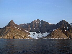 Bishop's Mitre in the Kaumajet Mountains | |
| Highest point | |
| Peak | Brave Mountain |
| Elevation | 1,300 m (4,300 ft) |
| Coordinates | 57°52′59.9″N 62°01′59.9″W / 57.883306°N 62.033306°W |
| Geography | |
| Country | Canada |
| Region | Labrador |
| Range coordinates | 57°48′N 61°51′W / 57.800°N 61.850°W |
| Parent range | Arctic Cordillera |
| Rank | Name | m | ft |
|---|---|---|---|
| 1 | Brave Mountain | 1300 | 4265 |
| 2 | Bishop's Mitre | 1113 | 3652 |
| 3 | The Finger | 1006+ | 3300+ |
| 4 | Peak 3300 (14F/13) | 1006+ | 3300+ |
| 5 | Cod Island High Point | 914+ | 3000+ |
| 6 | Cod Island Peak | 823+ | 2700+ |
| 7 | Cod Island Peak | 792+ | 2600+ |
| 8 | Drachart Island High Point | 726+ | 2500+ |
See also edit
External links edit
- "Kaumajet Mountains". Peakbagger.com.