


Summary
The Keddie Wye is a railroad junction in the form of a wye on the Union Pacific Railroad in Plumas County, California, United States. Located at the town of Keddie, it joins the east-west Feather River Route and the "Inside Gateway"—formally, the BNSF Gateway Subdivision—which runs north to Bieber.

Keddie Wye | |||||||||||||||||||||||||||||||||||||||||||||||||||||||||||||||||||||||||||||
|---|---|---|---|---|---|---|---|---|---|---|---|---|---|---|---|---|---|---|---|---|---|---|---|---|---|---|---|---|---|---|---|---|---|---|---|---|---|---|---|---|---|---|---|---|---|---|---|---|---|---|---|---|---|---|---|---|---|---|---|---|---|---|---|---|---|---|---|---|---|---|---|---|---|---|---|---|---|
| |||||||||||||||||||||||||||||||||||||||||||||||||||||||||||||||||||||||||||||
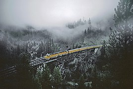
A notable feat of railroad engineering, it is the world's only wye with two legs on bridges that meet in a tunnel.[1] The west and north legs of the wye are on bridges over Spanish Creek, and the southeast leg runs through a tunnel (Tunnel No. 32).[2] Just to the northwest, where the two bridged legs join, is Tunnel No. 31.
The wye and the town are named for Arthur W. Keddie, who purchased the survey rights and the right to build a railroad through the Feather River Canyon from George Jay Gould, the son of Jay Gould.
History edit
The Western Pacific Railroad (now part of the Union Pacific) built the tracks along the Feather River in 1909 to complete a route from the San Francisco Bay Area to Salt Lake City, Utah, providing an alternate to the Southern Pacific's route over Donner Pass. Keddie was the site of the "last spike" ceremony held on November 1, 1909.[3]
The Feather River route was preferred by some over the Donner Pass route through the Sierra Nevada because the high point of the former (the Chilcoot Tunnel under Beckwourth Pass) is at a lower elevation — about 5,000 ft (1,500 m) as opposed to 7,000 ft (2,100 m) — and most of the route is at a gentler grade than the line over Donner Pass.[4]
Construction started on the branch running north to Bieber in 1930[5] and was completed in 1931, along with the north and southeast legs of the wye. This allowed the Western Pacific to diverge from its east-west route (along the west leg of the wye) and go north to an interchange with the Great Northern Railway (now BNSF Railway) and its traffic from the Pacific Northwest.[6]
Railfanning edit
The Keddie Wye is a favorite railfan spot and is part of Plumas County's 7 Wonders of the Railroad World.[7][8][9] Access to the site is described in the county travel guide.[9][10]
-

-
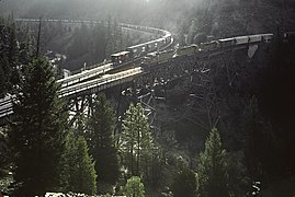
 UP Officers Special (Feb 1983)
 -
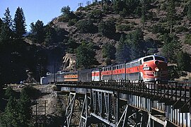 WP California Zephyr at Keddie Wye (Aug 1969)
 -
 Westbound train waits for northbound train to clear Tunnel 31 (Mar 1983)


References edit
- ^ "Keddie Wye". Atlas Obscura. Retrieved July 27, 2022.
- ^ "USGS Topographic Map of Keddie Wye and vicinity". Archived from the original on March 31, 2012. Retrieved January 22, 2010.
- ^ "Western Pacific in Utah". Utah Rails. Retrieved May 1, 2017.
- ^ Carrere, J.F. (August 28, 1910). "Westward Ho over the Western Pacific". Sacramento Union. Archived from the original on May 14, 2021. Retrieved May 1, 2017.
From Salt Lake to San Francisco is 921 miles (1,482 km) over the Western Pacific, and as the distance from Sacramento to San Francisco over the same route is 139 miles (224 km), it follows that from the capital of California to the capital of Utah is 782 miles (1,259 km). While that is longer than the route of the Southern Pacific the lower grade over the new road enables it to more than make up in speed what it loses in distance.
[...]Salt Lake City is 4,224 feet (1,287 m) above sea level. The highest point on the Western Pacific is 5,819 feet (1,774 m) at Silver Zone, one hundred and fifty miles west of that city. So there is quite a rapid ascent going east, but from Silver Zone until California is reached the altitude is never less than 3800 feet, so that the natural grade is not heavy compared with some of the other roads. For 42 miles (68 km) in one place the road is perfectly straight and perfectly level, for other long distances it does not exceed two-fifths of 1 per cent, and it never passes 1 per cent. - ^ "Bang! And a New Rail System Started". Healdsburg Tribune. August 19, 1930. Retrieved May 1, 2017.
- ^ "Ceremony Joins Railroads". Healdsburg Tribune. November 10, 1931. Retrieved May 1, 2017.
- ^ Bartell, John (January 13, 2023). "The Seven Railroad Wonders of the Feather River Canyon". KXTV ABC10. Retrieved February 19, 2024.
- ^ "7 Wonders of the Railroad World" (PDF). Plumas county Visitors Bureau. Archived from the original (PDF) on July 18, 2011. Retrieved May 1, 2017.
- ^ a b "Tour 7 - Wonders of the Railroad World" (PDF). Plumas County Visitors Bureau. Archived from the original (PDF) on November 23, 2015. Retrieved April 16, 2012.
- ^ Nevada, Utah & Southern Idaho Railroad Maps (Map). Cartography by David J. Cooley. Sonrisa Publications. 2004. Archived from the original on June 12, 2010. Retrieved December 26, 2010.
External links edit
- Western Pacific Railroad Museum in Portola, California
- Western Pacific Pictures - Bieber train waits on the Keddie Wye
- Historical Guide to North American Railroads (2nd ed.). Waukesha, Wisconsin: Kalmbach Books. 2000.
- Keddie Wye, Quincy, California - A showcase of engineering might that was also symbolic of westward expansion
- WP's Keddie Wye
40°01′06″N 120°57′27″W / 40.01844°N 120.95760°W