


Summary
Kelvington is a town of 864 residents in the rural municipality of Kelvington No. 366, in the Canadian province of Saskatchewan. Kelvington is located at the intersection of Highway 38 and Highway 49. It is east of Saskatoon.
Kelvington | |
|---|---|
Town | |
| Motto: Grow With Us | |
 Kelvington Location of Kelvington in Saskatchewan | |
| Coordinates: 52°10′N 103°32′W / 52.167°N 103.533°W | |
| Country | Canada |
| Province | Saskatchewan |
| Rural Municipalities (R.M.) | Kelvington |
| Post office Founded | 1906-09-01 |
| Government | |
| • Federal Electoral District of Yorkton—Melville M.P. | Cathay Wagantall (2015) |
| • Provincial Constituency of Kelvington-Wadena M.L.A. | Hugh Nerlien (2016) |
| Area | |
| • Total | 3.89 km2 (1.50 sq mi) |
| Population (2022)[1] | |
| • Total | 6,969 |
| • Density | 221.9/km2 (575/sq mi) |
| Time zone | UTC−6 (Central Standard Time) |
| Postal code | S0A 1W0 |
| Area code | 306 |
| Highways | Hwy 38, Hwy 49 |
| Website | Official website |
| [2][3][4][5] | |
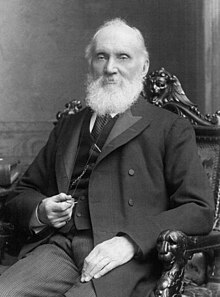
The town was named for William Thomson, 1st Baron Kelvin, scientist and inventor.
Geography edit
Kelvington is geographically situated in the parkland region of Saskatchewan and is surrounded by numerous lakes: Big and Little Quill Lakes, Ponass Lakes, Nut Lake, Little Nut Lake, Round Lake, and Fishing Lake going around clockwise. Kelvington is 237 kilometres (147 mi) east from the nearest major city of Saskatoon.
Demographics edit
In the 2021 Census of Population conducted by Statistics Canada, Kelvington had a population of 827 living in 406 of its 469 total private dwellings, a change of -0.8% from its 2016 population of 834. With a land area of 3.87 km2 (1.49 sq mi), it had a population density of 213.7/km2 (553.5/sq mi) in 2021.[6]
| 2021 | 2011 | |
|---|---|---|
| Population | 827 (-0.8% from 2016) | 864 (-0.2% from 2006) |
| Land area | 3.87 km2 (1.49 sq mi) | 3.89 km2 (1.50 sq mi) |
| Population density | 213.8/km2 (554/sq mi) | 221.9/km2 (575/sq mi) |
| Median age | 54.8 (M: 54.0, F: 56.0) | 54.9 (M: 51.9, F: 56.5) |
| Private dwellings | 469 (total) 406 (occupied) | 464 (total) |
| Median household income | $58,000 |
Attractions edit
The following are attractions near Kelvington:
- Round Lake Recreation Site
- Marean Lake is located 40 km (25 mi) north of Kelvington.
- Fishing Lake Regional Park is located 35 km (22 mi) south of Kelvington.
- Greenwater Lake Provincial Park is located 40 km (25 mi) north of Kelvington.
Infrastructure edit
Transportation edit
Besides being at the intersection of a secondary grade and primary grade, Highway 38 and Highway 49. Kelvington is also home to the Kelvington Airport CKV2 which has a 2500-foot turf runway with no winter maintenance. Kelvington is also located along the CPR railway.[11] and the Route 66 Snowmobile Trail.[12]
Health care edit
The Kelvington and Area Hospital opened in June 2016. It replaces the aging facility opened in 1969. The hospital is an integrated facility containing seven acute care beds, medical clinic, 24 hour emergency services, home care offices, lab, and diagnostic imaging services. It also hosts several itinerant specialists including occupational therapy, public health, physio therapy and more. Attached to this facility is a 45 bed long term care facility that is currently being renovated, with completion expected by April 2017.[13]
Ambulance services are located within the community and includes three ambulances with Advanced Care Paramedics.[14]
East Central Saskatchewan Association for the Rehabilitation of the Brain Injured (SARBI) is a rehabilitation facility which is located in Kelvington and services a one hundred mile radius. This facility provides services and therapy for individuals who have experienced a brain injury from trauma or illness.
Media edit
Kelvington is serviced by the Northeast Chronicle and Wadena News. The nearest radio station is located in Humboldt, Saskatchewan - CHBO-FM 107.5[15]
Notable people edit
- Barry Melrose, ice hockey player in the NHL and WHA and coach in the NHL
- Joe Kocur, ice hockey player in the NHL
- Wendel Clark, ice hockey player in the NHL
- Kerry Clark, ice hockey player in the NHL
- Kory Kocur, ice hockey player in the NHL
References edit
- ^ "2011 Community Profiles". Statistics Canada. Government of Canada. Archived from the original on December 26, 2018. Retrieved August 16, 2014.
- ^ National Archives, Archivia Net. "Post Offices and Postmasters". Archived from the original on October 6, 2006. Retrieved May 26, 2007.
- ^ Government of Saskatchewan, MRD Home. "Municipal Directory System". Archived from the original on January 15, 2016. Retrieved August 16, 2014.
- ^ Canadian Textiles Institute. (2005). "CTI Determine your provincial constituency". Archived from the original on September 11, 2007. Retrieved May 26, 2007.
- ^ Commissioner of Canada Elections, Library of Parliament (2008). "Riding history for Yorkton—Melville (1966– )". Archived from the original on December 8, 2012. Retrieved October 28, 2008.
- ^ "Population and dwelling counts: Canada, provinces and territories, census divisions and census subdivisions (municipalities), Saskatchewan". Statistics Canada. February 9, 2022. Retrieved April 1, 2022.
- ^ "2021 Community Profiles". 2021 Canadian Census. Statistics Canada. February 4, 2022. Retrieved October 19, 2023.
- ^ "2011 Community Profiles". 2011 Canadian Census. Statistics Canada. March 21, 2019. Retrieved August 16, 2014.
- ^ "2006 Community Profiles". 2006 Canadian Census. Statistics Canada. August 20, 2019.
- ^ "2001 Community Profiles". 2001 Canadian Census. Statistics Canada. July 18, 2021.
- ^ Adamson, J. "Saskatchewan, Canada, Rand McNally 1924 Indexed Pocket Map Tourists' and Shippers' Guide". Canadian map. Retrieved June 7, 2007.
- ^ "Newsask Community Futures Development Corporation". Retrieved June 7, 2007.
- ^ "Kelvington". Saskatchewan Health Authority. Saskatchewan Health Authority. Retrieved April 6, 2023.
- ^ "Kelvington MHS". Kelvington MHS. Kelvington Mobile Health Services. Retrieved April 6, 2023.
- ^ "Town of Kelvington News & Radio". Archived from the original on September 27, 2007. Retrieved June 3, 2007.