


Summary
The Keningau District (Malay: Daerah Keningau) is an administrative district in the Malaysian state of Sabah, part of the Interior Division which includes the districts of Beaufort, Keningau, Kuala Penyu, Nabawan, Sipitang, Tambunan and Tenom. The capital of the district is in Keningau Town. Dusun, Murut and Lundayeh are the major ethnics in Keningau.
Keningau District | |
|---|---|
| Daerah Keningau | |
| Other transcription(s) | |
| • Jawi | داءيره كنيڠاو |
| • Chinese | 根地咬县 (Simplified) 根地咬縣 (Traditional) Gēndeyǎo xiàn (Hanyu Pinyin) |
| • Tamil | கெனிங்காவு மாவட்டம் Keṉiṅkāvu māvaṭṭam (Transliteration) |
| • Kadazandusun | Watas Keningau |
 Keningau District Council office. | |
 Flag Seal | |
 | |
| Coordinates: 5°20′00″N 116°10′00″E / 5.33333°N 116.16667°E | |
| Country | |
| State | |
| Division | Interior |
| Municipality | 1 January 2022 |
| Capital | Keningau |
| Government | |
| • District Officer | Amat Mohd Yusof |
| Area | |
| • Total | 3,533 km2 (1,364 sq mi) |
| Population (2010) | |
| • Total | 173,103 |
| Website | www www |

Etymology edit
The name Keningau is derived from the locally-abundant Javanese cinnamon tree (Cinnamomum burmannii) which is locally known as Koningau.[1]
History edit
Keningau was one of the most important administrative centres for the British North Borneo in the early years of the 20th century. The Japanese also used Keningau as a government centre during their occupation in the Second World War. The village of Nuntunan near Apin-Apin was numbered "44" in the British administration. The number stated the distance about 44 kilometres from Tenom. Nuntunan was also called the "Office" because the British administration building was on the banks of the Apin-apin River. The Japanese took over the building for their own administration during the occupation.
Geography edit
The district of Keningau covers an area of 3,533 square kilometres and is located in a valley bordered to the west by the Crocker Range and to the south and east by the Mount Trus Madi.
Demographics edit
The population of the district of Keningau is 173,103 according to the last census in 2010.[2] It consists of 90% of mainly Dusun and Murut peoples, as well an estimate of 8% Hakka Chinese population and various minority indigenous groups.
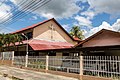
Gallery edit
-
 Ar-Rahim Mosque
 -
 St. Margaret Anglican Church.
 -
 Keningau Basel Church.
 -
 Sign board to Sook Holy Spirit Catholic Church.
 -
 Keningau Seventh Day Adventist Church.
 -
 Keningau Temple.
 -
 Keningau fog.
 -
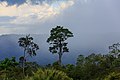 Keningau rainforest after rain.


See also edit
References edit
- ^ "Sejarah Farrah" (in Malay). Keningau District Office. Archived from the original on 7 November 2017. Retrieved 7 November 2017.
- ^ "Population by ethnic group, Local Authority area and state, Malaysia" (PDF). Department of Statistics, Malaysia. 2010. Archived from the original (PDF) on 27 February 2012. Retrieved 5 November 2017.
Further reading edit
- Treacher, W. H (1891). "British Borneo: sketches of Brunai, Sarawak, Labuan, and North Borneo". University of California Libraries. Singapore, Govt. print. dept. p. 190.
- Rutter, Owen (1922). "British North Borneo - An Account of its History, Resources and Native Tribes". Cornell University Libraries. Constable & Company Ltd, London. p. 157.
- Tregonning, K. G. (1965). A History Of Modern Sabah (North Borneo 1881–1963). University of Malaya Press.
External links edit
![]() Media related to Keningau District at Wikimedia Commons
Media related to Keningau District at Wikimedia Commons
- (in Malay) Keningau District Council
- (in Malay) Keningau District Office