


Summary
Kentland is a town in Jefferson Township, Newton County, in the U.S. state of Indiana.[2] The population was 1,641 at the 2020 census.
Kentland, Indiana | |
|---|---|
Town | |
| Town of Kentland | |
 Downtown Kentland, Indiana | |
 Location of Kentland in Newton County, Indiana. | |
| Coordinates: 40°46′26″N 87°26′47″W / 40.77389°N 87.44639°W | |
| Country | United States |
| State | Indiana |
| County | Newton |
| Township | Jefferson |
| Area | |
| • Total | 1.35 sq mi (3.50 km2) |
| • Land | 1.35 sq mi (3.50 km2) |
| • Water | 0.00 sq mi (0.00 km2) |
| Elevation | 676 ft (206 m) |
| Population (2020) | |
| • Total | 1,641 |
| • Density | 1,215.56/sq mi (469.41/km2) |
| Time zone | UTC-6 (Central (CST)) |
| • Summer (DST) | UTC-5 (CDT) |
| ZIP code | 47951 |
| Area code | 219 |
| FIPS code | 18-39546[3] |
| GNIS feature ID | 2397015[2] |
History edit
The town was founded in 1860 as "Kent", though this name was soon lengthened to Kentland. The name honors Alexander J. Kent,[4] who acquired the then marshy plat and prepared it for development. The town is the county seat of Newton County.[5]
Kentland is the birthplace of famous turn-of-the-century humorist George Ade, author of such plays as The College Widow, Artie, and The Sultan of Sulu. Purdue University's Ross–Ade Stadium, home of the Boilermakers football team, is named for him and fellow Purdue benefactor David Ross. Disgraced Indiana governor Warren McCray, convicted of mail fraud and forced to resign in 1924, also hailed from Kentland.
The Newton County Courthouse was listed on the National Register of Historic Places in 2008.[6]
Geography edit
According to the 2010 census, Kentland has a total area of 1.53 square miles (3.96 km2), all land.[7]
The Kentland crater, a probable meteorite impact crater, is located between Kentland and Goodland.
Demographics edit
| Census | Pop. | Note | %± |
|---|---|---|---|
| 1870 | 802 | — | |
| 1880 | 982 | 22.4% | |
| 1890 | 918 | −6.5% | |
| 1900 | 1,006 | 9.6% | |
| 1910 | 1,209 | 20.2% | |
| 1920 | 1,283 | 6.1% | |
| 1930 | 1,355 | 5.6% | |
| 1940 | 1,608 | 18.7% | |
| 1950 | 1,633 | 1.6% | |
| 1960 | 1,783 | 9.2% | |
| 1970 | 1,864 | 4.5% | |
| 1980 | 1,936 | 3.9% | |
| 1990 | 1,798 | −7.1% | |
| 2000 | 1,822 | 1.3% | |
| 2010 | 1,748 | −4.1% | |
| 2020 | 1,641 | −6.1% | |
| U.S. Decennial Census[8] | |||
2010 census edit
As of the census[9] of 2010, there were 1,748 people, 695 households, and 450 families living in the town. The population density was 1,142.5 inhabitants per square mile (441.1/km2). There were 782 housing units at an average density of 511.1 per square mile (197.3/km2). The racial makeup of the town was 94.2% White, 0.8% African American, 0.1% Native American, 0.5% Asian, 2.6% from other races, and 1.8% from two or more races. Hispanic or Latino of any race were 8.0% of the population.
There were 695 households, of which 30.5% had children under the age of 18 living with them, 46.9% were married couples living together, 11.9% had a female householder with no husband present, 5.9% had a male householder with no wife present, and 35.3% were non-families. 30.9% of all households were made up of individuals, and 13.4% had someone living alone who was 65 years of age or older. The average household size was 2.46 and the average family size was 3.02.
The median age in the town was 40.9 years. 24.7% of residents were under the age of 18; 7.7% were between the ages of 18 and 24; 21.4% were from 25 to 44; 30.3% were from 45 to 64; and 15.8% were 65 years of age or older. The gender makeup of the town was 49.0% male and 51.0% female.
2000 census edit
As of the census[3] of 2000, there were 1,822 people, 733 households, and 477 families living in the town. The population density was 1,250.5 inhabitants per square mile (482.8/km2). There were 793 housing units at an average density of 544.3 per square mile (210.2/km2). The racial makeup of the town was 98.30% White, 0.11% African American, 0.27% Asian, 0.82% from other races, and 0.49% from two or more races. Hispanic or Latino of any race were 2.96% of the population.
There were 733 households, out of which 29.7% had children under the age of 18 living with them, 50.3% were married couples living together, 10.8% had a female householder with no husband present, and 34.9% were non-families. 30.4% of all households were made up of individuals, and 14.3% had someone living alone who was 65 years of age or older. The average household size was 2.42 and the average family size was 3.03.
In the town, the population was spread out, with 24.7% under the age of 18, 9.4% from 18 to 24, 27.2% from 25 to 44, 22.1% from 45 to 64, and 16.6% who were 65 years of age or older. The median age was 39 years. For every 100 females there were 96.8 males. For every 100 females age 18 and over, there were 90.3 males.
The median income for a household in the town was $34,732, and the median income for a family was $45,043. Males had a median income of $32,734 versus $20,714 for females. The per capita income for the town was $17,797. About 4.7% of families and 7.5% of the population were below the poverty line, including 5.6% of those under age 18 and 13.8% of those age 65 or over.
Education edit
The town has a lending library, the Kentland-Jefferson Township Public Library.[10]
Notable people edit
- George Ade, columnist and author; Ross–Ade Stadium at Purdue University is named for him.
- Alice Chancellor, Army engineer
- Jethro A. Hatch, was the first physician in Kentland and a U.S. Representative from Indiana.
- Warren T. McCray, 30th Governor of Indiana.
- Tracy Smith, former Arizona State baseball coach.
Gallery edit
-
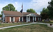 The town hall
 -
 The time capsule


References edit
- ^ "2020 U.S. Gazetteer Files". United States Census Bureau. Retrieved March 16, 2022.
- ^ a b c U.S. Geological Survey Geographic Names Information System: Kentland, Indiana
- ^ a b "U.S. Census website". United States Census Bureau. Retrieved January 31, 2008.
- ^ Ade, John (1911). Newton County: A Collection of Historical Facts and Personal Recollections Concerning Newton County, Indiana, from 1853 to 1911. Bobbs-Merrill. pp. 192.
- ^ "Find a County". National Association of Counties. Archived from the original on May 31, 2011. Retrieved June 7, 2011.
- ^ "National Register Information System". National Register of Historic Places. National Park Service. July 9, 2010.
- ^ "G001 - Geographic Identifiers - 2010 Census Summary File 1". United States Census Bureau. Archived from the original on February 13, 2020. Retrieved July 17, 2015.
- ^ "Census of Population and Housing". Census.gov. Retrieved June 4, 2015.
- ^ "U.S. Census website". United States Census Bureau. Retrieved December 11, 2012.
- ^ "Indiana public library directory" (PDF). Indiana State Library. Archived from the original (PDF) on February 18, 2017. Retrieved March 10, 2018.
- George Pence and Nellie C. Armstrong (1933). Indiana Boundaries: Territory, State and County. Indiana Historical Society.
External links edit
- "Warren T. McCray" https://web.archive.org/web/20081204174258/http://www.countyhistory.com/doc.gov/033.htm
- "Earth Impact Database: Kentland" https://www.unb.ca/passc/ImpactDatabase/images/kentland.htm
- "South Newton High School" http://www.newton.k12.in.us