


Summary
Khirbet Tibnah (also Tibneh[1]), is located on the West Bank, between the villages Deir Nidham and Nabi Salih.
 | |
 Shown within the West Bank | |
| Coordinates | 32°00′30″N 35°06′40″E / 32.00833°N 35.11111°E |
|---|---|
| Grid position | 16035/15725 PAL |
History edit
Antiquity edit

Schürer wrote in the 1880s that Thamna (Greek: Θαμνά) – a city within the district of Diospolis (=Lydda) and which served once as a toparchy (administrative city) during the Roman period – is to be identified with the biblical city of Timnath-serah, now known as the ruin (khirba in Arabic) of Tibnah (Tibneh) in Samaria.[2] He also quoted Eusebius who wrote at the beginning of the 4th century that the tomb of Joshua was in his time still visited at a place near the village.[2]
Roman and Byzantine periods edit

Ceramics from the late Roman and the Byzantine eras have been found here (at grid 1603/1573).[3]
On the north slope of the hill south of Khirbet Tibnah lies a Jewish necropolis dating back to the Hellenistic period up to the Bar Kokhba revolt. The rock-cut tombs have kokhim that are typical to that period. In some of them were the remains of ossuaries. In the valley just below the necropolis there is a large mikveh with two entrances.[4]
Crusader period edit
Khirbet Tibnah is one of the places suggested identified with the Crusader Tyberie.[5]
Ottoman period edit
In 1596, the Tibnah (Tibya) site was listed as village in the nahiya Quds, in the administrative district Liwā` of Jerusalem, in a tax ledger of the "countries of Syria" (wilāyat aš-Šām) and which lands were then under Ottoman rule. During that year, Tibna was inhabited by 20 family heads, all Muslim. The Ottoman authority levied a 33.3% taxation on agricultural products produced by the villagers (primarily on wheat, barley, and olives), besides a marriage tax and supplement tax on goats and beehives. Total revenues accruing from the village of Tibna for that year amounted to 3700 akçe.[7]
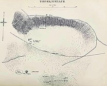
Charles William Wilson, who travelled through Palestine in 1866, reported a cemetery containing nine tombs south of the town, which was once capital of the surrounding district: one of these tombs was large, with a portico supported on piers of rock with very simple capitals. One of the piers was apparently destroyed between 1866 and 1873. There were niches for over 200 lamps at the tomb entrance. Inside was a chamber with fourteen graves, or kokhim, with a passage leading into an inner chamber containing one grave. He also wrote about a 40 foot high oak tree near the tomb, known as Sheikh et-Teim, and a village about 3 miles to the east, called Kefr Ishu'a, or Joshua's Village.[citation needed]
Both in 1863 and in 1870 Guérin visited, and described several ruins.[8] Khirbet Tibnah is described in 1882 as a tell overlooking a deep valley (Wady Reiya) on the north and the ancient Roman road to the south. A cemetery was situated on a flat hill nearby, and to the northwest, the spring of Ein Tibnah emerged from a rocky channel. On the southwest was an oak tree some 30 or 40 feet high, and two wells, one of them dry. West of the tree were traces of ruins believed to be those of an Arab village.[9]
Mandate period edit
The village was not inhabited in the late mandatory period.[7]
See also edit
- Khirbet et-Tibbaneh aka Timnah of Judah, site in the Judaean Mountains
References edit
- ^ meaning "straw", Palmer, 1881, p. 246
- ^ a b Schürer, 1891, p. 158, note 438.
- ^ Dauphin, 1998, p. 826
- ^ Raviv, Dvir (2017). "שרידים מתקופת בית שני עד מרד בר כוכבא בתל תמנה שבדרום השומרון" (PDF). במעבה ההר. 7 (7): 13–51 – via כתב עת לארכיאולוגיה והיסטוריה של אזור ההר.
- ^ Röhricht, 1887, p. 222; cited in Finkelstein, 1997, p. 367
- ^ Conder and Kitchener, 1882, p. 375
- ^ a b Hütteroth and Abdulfattah, 1977, p. 114
- ^ Guérin, 1875, pp. 89-93
- ^ Conder and Kitchener, 1882, p. 374
Bibliography edit
- Conder, C.R.; Kitchener, H. H. (1882). The Survey of Western Palestine: Memoirs of the Topography, Orography, Hydrography, and Archaeology. Vol. 2. London: Committee of the Palestine Exploration Fund.
- Dauphin, C. (1998). La Palestine byzantine, Peuplement et Populations. BAR International Series 726 (in French). Vol. III : Catalogue. Oxford: Archeopress. ISBN 0-860549-05-4.
- Finkelstein, I.; Lederman, Zvi, eds. (1997). Highlands of many cultures. Tel Aviv: Institute of Archaeology of Tel Aviv University Publications Section. ISBN 965-440-007-3. (p. 367)
- Guérin, V. (1875). Description Géographique Historique et Archéologique de la Palestine (in French). Vol. 2: Samarie, pt. 2. Paris: L'Imprimerie Nationale.
- Hütteroth, Wolf-Dieter; Abdulfattah, Kamal (1977). Historical Geography of Palestine, Transjordan and Southern Syria in the Late 16th Century. Erlanger Geographische Arbeiten, Sonderband 5. Erlangen, Germany: Vorstand der Fränkischen Geographischen Gesellschaft. ISBN 3-920405-41-2.
- Palmer, E.H. (1881). The Survey of Western Palestine: Arabic and English Name Lists Collected During the Survey by Lieutenants Conder and Kitchener, R. E. Transliterated and Explained by E.H. Palmer. Committee of the Palestine Exploration Fund.
- Röhricht, R. (1887). "Studien zur mittelalterlichen Geographie und Topographie Syriens". Zeitschrift des Deutschen Palästina-Vereins. 10: 195–344.
- Schürer, E. (1891). Geschichte des jüdischen Volkes im Zeitalter Jesu Christi [A History of the Jewish People in the Time of Jesus Christ]. Vol. 1. Translated by Miss Taylor. New York: Charles Scribner's Sons. p. 158 (note 438).
External links edit
- Tibneh, Biblewalks
- Survey of Western Palestine, 1880 Map, Map 14: IAA, Wikimedia commons Tibneh (Sheikh et Teim)